Remote sensing offers broad-scale, real-time monitoring of drought conditions by capturing satellite imagery and environmental data, enabling early detection across vast agricultural regions. Ground-based observation provides localized, precise measurements of soil moisture and atmospheric conditions critical for validating and calibrating remote sensing data. Integrating both methods enhances the accuracy and reliability of drought detection, supporting effective agricultural management and mitigation strategies.
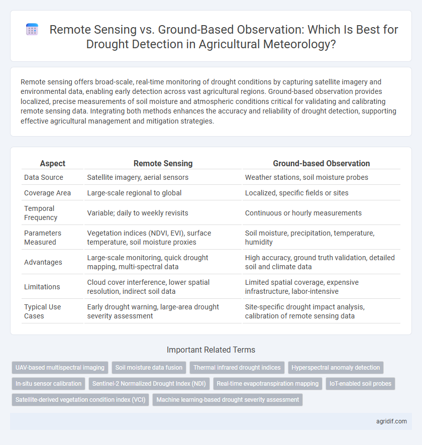
Table of Comparison
| Aspect | Remote Sensing | Ground-based Observation |
|---|---|---|
| Data Source | Satellite imagery, aerial sensors | Weather stations, soil moisture probes |
| Coverage Area | Large-scale regional to global | Localized, specific fields or sites |
| Temporal Frequency | Variable; daily to weekly revisits | Continuous or hourly measurements |
| Parameters Measured | Vegetation indices (NDVI, EVI), surface temperature, soil moisture proxies | Soil moisture, precipitation, temperature, humidity |
| Advantages | Large-scale monitoring, quick drought mapping, multi-spectral data | High accuracy, ground truth validation, detailed soil and climate data |
| Limitations | Cloud cover interference, lower spatial resolution, indirect soil data | Limited spatial coverage, expensive infrastructure, labor-intensive |
| Typical Use Cases | Early drought warning, large-area drought severity assessment | Site-specific drought impact analysis, calibration of remote sensing data |
Introduction to Drought Detection in Agriculture
Remote sensing provides large-scale, real-time data on soil moisture, vegetation health, and precipitation anomalies that are crucial for early drought detection in agriculture. Ground-based observations offer precise, localized measurements of soil moisture and crop stress, facilitating accurate assessment of drought severity and impacts. Integrating remote sensing with ground-based data enhances drought monitoring, enabling timely interventions to mitigate agricultural losses.
Overview of Remote Sensing Technologies
Remote sensing technologies for drought detection leverage satellite-based sensors to monitor vegetation health, soil moisture, and surface temperature over large geographic scales, providing consistent and timely data. Common tools include multispectral and thermal infrared sensors that capture data on plant stress and evapotranspiration rates, which are critical for early drought identification. This spatial and temporal coverage allows for near-real-time drought monitoring, outperforming ground-based observations limited by location and accessibility.
Ground-based Observation Methods for Drought Monitoring
Ground-based observation methods for drought monitoring rely on in-situ data collection from weather stations, soil moisture sensors, and plant health assessments to provide precise and localized drought indicators. These methods deliver high temporal resolution and real-time measurements essential for understanding soil water content, evapotranspiration rates, and crop stress levels. Integration of ground-based data with meteorological and hydrological metrics enhances accuracy in drought severity classification and supports adaptive agricultural management practices.
Data Accuracy: Remote Sensing vs Ground-based Observation
Remote sensing provides broad spatial coverage with consistent temporal resolution, capturing drought indicators such as soil moisture and vegetation health over large agricultural areas. Ground-based observations deliver highly accurate, localized data, including soil moisture levels and atmospheric conditions, but their limited spatial range can miss regional drought variability. Combining remote sensing's extensive spatial data with ground-based precision enhances drought detection accuracy, enabling more effective agricultural meteorology decisions.
Spatial and Temporal Coverage Comparison
Remote sensing offers expansive spatial coverage, capturing drought conditions across vast agricultural regions with consistent temporal frequency, often revisiting the same area daily or weekly via satellites like MODIS and Landsat. Ground-based observations provide high-resolution, localized data crucial for validating remote sensing outputs but are limited by sparse distribution and less frequent measurements driven by station maintenance and operational constraints. Integrating both approaches enhances drought detection accuracy, leveraging remote sensing for broad spatial-temporal patterns and ground stations for detailed, site-specific insights.
Cost-Effectiveness of Drought Detection Approaches
Remote sensing offers cost-effective drought detection by covering large agricultural areas quickly and frequently, reducing the need for extensive ground personnel and infrastructure. Ground-based observation requires significant investment in sensors, maintenance, and labor, making it less economical for widespread monitoring. Integrating remote sensing data with targeted ground measurements enhances accuracy while optimizing overall expenses.
Challenges of Remote Sensing Applications
Remote sensing in agricultural meteorology faces challenges such as limited spatial resolution, atmospheric interference, and cloud cover obscuring satellite data, which can compromise drought detection accuracy. Variability in sensor calibration and data interpretation complexity further hinder consistent monitoring of soil moisture and vegetation health. These obstacles necessitate integration with ground-based observations to enhance reliability and precision in drought assessment.
Limitations in Ground-based Drought Monitoring
Ground-based drought monitoring faces significant limitations due to sparse weather station networks that hinder accurate spatial coverage and microclimate detection. Sensor malfunctions, maintenance challenges, and data gaps reduce reliability and timeliness of drought information. These constraints limit the ability to predict localized drought onset and severity compared to more comprehensive remote sensing data.
Integrating Remote Sensing and Ground-based Data
Integrating remote sensing with ground-based observation enhances drought detection accuracy by combining satellite-derived indices such as NDVI and soil moisture with in-situ measurements of precipitation and soil water content. This fusion enables comprehensive monitoring of drought onset, duration, and severity across diverse spatial and temporal scales. Advanced data assimilation techniques improve drought models, supporting precision agriculture and effective water resource management.
Future Trends in Drought Detection Technologies
Advancements in agricultural meteorology emphasize integrating remote sensing and ground-based observations to enhance drought detection accuracy. Emerging technologies leverage high-resolution satellite imagery and IoT-enabled soil moisture sensors to provide real-time, precise drought monitoring at multiple scales. Future trends indicate increased utilization of artificial intelligence and machine learning algorithms to synthesize data, improving early warning systems and adaptive drought management strategies.
Related Important Terms
UAV-based multispectral imaging
UAV-based multispectral imaging provides high-resolution, real-time data crucial for precise drought detection, surpassing the spatial limitations of traditional ground-based observation methods. This technology enhances the monitoring of crop stress and moisture variability by capturing detailed spectral information unavailable through conventional meteorological instruments.
Soil moisture data fusion
Remote sensing offers extensive spatial coverage and frequent soil moisture measurements, while ground-based observations provide high accuracy and localized ground truth data; combining these sources through data fusion enhances the precision and reliability of drought detection models. Integrating satellite-derived soil moisture indices with in-situ sensor networks improves early warning capabilities and supports effective water resource management in agricultural meteorology.
Thermal infrared drought indices
Thermal infrared drought indices derived from remote sensing provide extensive spatial coverage and enable frequent monitoring of crop stress and soil moisture variations across diverse agricultural landscapes. Ground-based observations offer precise, localized data essential for validating remote sensing measurements and capturing microclimatic factors influencing drought severity.
Hyperspectral anomaly detection
Hyperspectral anomaly detection in remote sensing offers precise identification of drought stress by analyzing spectral variations across crop canopies, surpassing ground-based observations limited by spatial coverage and temporal frequency. Integrating hyperspectral data with meteorological models enhances early drought detection, enabling proactive agricultural management and mitigation strategies.
In-situ sensor calibration
In-situ sensor calibration is critical for enhancing the accuracy of remote sensing data in drought detection by providing ground-truth measurements that reduce systematic errors and biases. Integrating ground-based observation networks with satellite-derived data ensures improved reliability and spatial resolution in monitoring soil moisture, vegetation health, and evapotranspiration rates essential for timely drought assessment.
Sentinel-2 Normalized Drought Index (NDI)
Sentinel-2's Normalized Drought Index (NDI) offers high-resolution, multispectral data critical for detecting and monitoring drought conditions over large agricultural landscapes, surpassing ground-based observation in spatial coverage and temporal frequency. Ground-based methods provide precise soil moisture and plant health data but lack the extensive reach and rapid revisit capabilities that Sentinel-2's NDI delivers for comprehensive drought assessment.
Real-time evapotranspiration mapping
Remote sensing enables real-time evapotranspiration mapping by continuously capturing large-scale spatial data, improving drought detection accuracy compared to ground-based observation methods that provide localized, time-lagged measurements. Integrating satellite-derived evapotranspiration indices with ground sensors enhances timely drought assessment and water resource management in agricultural meteorology.
IoT-enabled soil probes
IoT-enabled soil probes provide continuous, real-time data on soil moisture and temperature, offering precise ground-level insights crucial for early drought detection in agricultural meteorology. Remote sensing complements this by covering large areas, but lacks the granular accuracy of IoT soil probes necessary for localized drought assessment and adaptive irrigation management.
Satellite-derived vegetation condition index (VCI)
Satellite-derived Vegetation Condition Index (VCI) offers comprehensive spatial coverage and real-time monitoring capabilities essential for early drought detection, outperforming ground-based observations limited by geographic scope and temporal frequency. Integration of VCI data with meteorological parameters enhances the accuracy of drought assessment, enabling proactive agricultural management and resource allocation.
Machine learning-based drought severity assessment
Remote sensing provides comprehensive spatial data essential for machine learning algorithms to accurately assess drought severity by analyzing vegetation indices, soil moisture, and thermal anomalies at regional scales. Ground-based observation offers high-precision, localized datasets that enhance model training and validation, improving predictive accuracy of drought conditions when integrated with remote sensing inputs.
Remote Sensing vs Ground-based Observation for Drought Detection Infographic