Convective rainfall forms from intense solar heating causing air to rise rapidly and cool, leading to localized heavy precipitation which is crucial for short-term agricultural water supply. Orographic rainfall occurs when moist air ascends mountain slopes, resulting in widespread and predictable precipitation patterns essential for long-term crop planning in hilly regions. Understanding the differences between convective and orographic rainfall enhances precipitation analysis, improving irrigation scheduling and crop yield forecasts in agricultural meteorology.
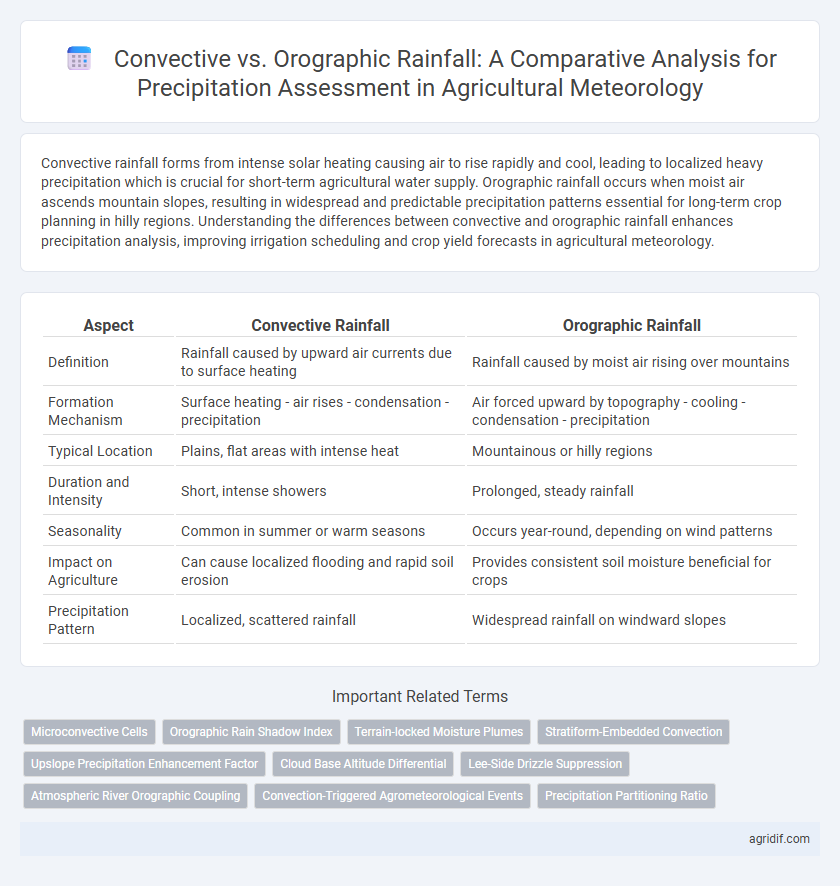
Table of Comparison
| Aspect | Convective Rainfall | Orographic Rainfall |
|---|---|---|
| Definition | Rainfall caused by upward air currents due to surface heating | Rainfall caused by moist air rising over mountains |
| Formation Mechanism | Surface heating - air rises - condensation - precipitation | Air forced upward by topography - cooling - condensation - precipitation |
| Typical Location | Plains, flat areas with intense heat | Mountainous or hilly regions |
| Duration and Intensity | Short, intense showers | Prolonged, steady rainfall |
| Seasonality | Common in summer or warm seasons | Occurs year-round, depending on wind patterns |
| Impact on Agriculture | Can cause localized flooding and rapid soil erosion | Provides consistent soil moisture beneficial for crops |
| Precipitation Pattern | Localized, scattered rainfall | Widespread rainfall on windward slopes |
Introduction to Precipitation in Agricultural Meteorology
Convective rainfall results from intense solar heating causing rapid air uplift, leading to localized and often heavy precipitation essential for crop irrigation cycles. Orographic rainfall occurs when moist air masses ascend mountainous terrain, cooling and condensing to produce steady, spatially distributed precipitation critical for managing water resources in hilly agricultural regions. Understanding these distinct precipitation mechanisms aids in optimizing planting schedules and irrigation management in agricultural meteorology.
Understanding Convective Rainfall Mechanisms
Convective rainfall results from the rapid upward movement of warm, moist air, leading to the formation of cumulonimbus clouds and intense, localized precipitation. This mechanism is driven by surface heating and atmospheric instability, which causes air parcels to rise, cool, and condense into rain droplets. Understanding convective rainfall is crucial for accurate precipitation analysis in agricultural meteorology, as it impacts soil moisture variability and crop water availability.
Key Features of Orographic Rainfall
Orographic rainfall occurs when moist air masses are forced to ascend over mountain ranges, causing cooling and condensation that result in precipitation primarily on the windward slopes. Its key features include a marked spatial distribution with heavy rainfall on the windward side and a rain shadow effect causing dry conditions on the leeward slopes. This type of precipitation plays a crucial role in agriculture by influencing localized soil moisture patterns and crop water availability in mountainous regions.
Atmospheric Conditions Influencing Rainfall Types
Convective rainfall develops from localized atmospheric instability where warm, moist air rises rapidly, resulting in short, intense precipitation typically observed in tropical and subtropical regions. Orographic rainfall occurs when moist air masses are forced to ascend over mountain ranges, cooling adiabatically and causing prolonged precipitation on the windward side, critical for watershed replenishment. Understanding vertical temperature gradients, humidity levels, and wind patterns is essential for distinguishing these rainfall types in agricultural meteorology and optimizing irrigation strategies.
Spatial Patterns of Convective vs. Orographic Precipitation
Convective rainfall typically exhibits localized, patchy spatial patterns due to intense upward air currents in unstable atmospheric conditions, often impacting small agricultural zones with high variability. Orographic rainfall displays more widespread, consistent spatial distribution along windward slopes of mountain ranges, driven by moist air forced to ascend terrain, providing reliable moisture for crops in these regions. Understanding these distinct spatial patterns is crucial for precise precipitation analysis and optimizing irrigation strategies in diverse agricultural landscapes.
Impacts on Soil Moisture and Crop Growth
Convective rainfall, characterized by intense, short-duration precipitation, rapidly increases soil moisture levels but can also lead to surface runoff and erosion, affecting nutrient availability for crops. Orographic rainfall tends to provide more consistent and evenly distributed moisture due to air mass cooling over elevated terrains, promoting sustained soil hydration essential for crop growth in mountainous agricultural regions. Understanding the spatial and temporal distribution differences between convective and orographic rainfall is critical for optimizing irrigation strategies and enhancing crop yield forecasts in diverse climatic zones.
Measurement Techniques for Rainfall Analysis
Convective rainfall measurement relies heavily on high-resolution radar systems and automated rain gauges to capture rapid, localized precipitation events. Orographic rainfall analysis incorporates remote sensing technologies and weighted gauge networks strategically placed along windward slopes to account for spatial variability. Utilizing these tailored measurement techniques enhances accuracy in quantifying precipitation patterns critical for agricultural meteorology and water resource management.
Modeling Rainfall Distribution in Farmlands
Convective rainfall results from localized intense heating causing air to rise and cool rapidly, often producing scattered, short-duration precipitation critical for understanding irrigation needs in farmlands. Orographic rainfall occurs when moist air ascends over elevated terrain, leading to sustained precipitation patterns that influence soil moisture levels and crop growth on windward slopes. Accurate modeling of these rainfall types requires integrating topographic data and atmospheric convection dynamics to optimize water resource management in agricultural meteorology.
Implications for Irrigation Planning and Management
Convective rainfall, characterized by intense, localized precipitation driven by surface heating, often results in short-duration, high-intensity rainfall events that challenge irrigation scheduling due to rapid runoff and infiltration variability. Orographic rainfall, influenced by topographic elevation and prevailing winds, typically produces more consistent and prolonged precipitation patterns critical for planning irrigation infrastructure in mountainous agricultural regions. Understanding these distinct rainfall types enhances water resource management, allowing for optimized irrigation timing and improved drought resilience in diverse agroclimatic zones.
Challenges and Future Directions in Precipitation Research
Convective rainfall, driven by localized thermal updrafts, presents challenges in precipitation analysis due to its high spatial and temporal variability, complicating accurate forecasting and water resource management. Orographic rainfall, influenced by topographic barriers, requires detailed terrain mapping and climate modeling to predict spatial distribution patterns effectively, yet it remains difficult to quantify in complex mountainous regions. Future precipitation research must integrate high-resolution remote sensing, advanced atmospheric models, and machine learning techniques to address these challenges and improve prediction accuracy for sustainable agricultural planning.
Related Important Terms
Microconvective Cells
Microconvective cells contribute to convective rainfall by rapidly rising warm, moist air that leads to localized, intense precipitation, crucial for precise agricultural meteorology forecasting. In contrast, orographic rainfall occurs when moist air masses ascend mountainous terrain, causing widespread precipitation patterns key to regional water resource management.
Orographic Rain Shadow Index
Orographic rainfall occurs when moist air ascends a mountain, causing precipitation on the windward side and creating a dry region known as the orographic rain shadow on the leeward side, quantified by the Orographic Rain Shadow Index (ORSI). Convective rainfall, driven by localized surface heating and atmospheric instability, contrasts with orographic patterns by producing scattered, short-duration storms, making ORSI a critical metric for assessing spatial precipitation variability in agricultural meteorology.
Terrain-locked Moisture Plumes
Convective rainfall forms from localized atmospheric instability and often produces intense, short-duration precipitation, while orographic rainfall occurs when moist air is forced over terrain, leading to sustained precipitation on windward slopes through terrain-locked moisture plumes. These terrain-locked moisture plumes enhance precipitation patterns by channeling and concentrating moisture along mountain ranges, significantly affecting spatial distribution in agricultural meteorology and water resource management.
Stratiform-Embedded Convection
Stratiform-embedded convection plays a crucial role in precipitation analysis by blending characteristics of both convective rainfall and orographic rainfall, leading to widespread and sustained precipitation patterns over agricultural lands. This hybrid rainfall mechanism enhances moisture distribution, supports crop irrigation, and influences soil moisture retention, making it vital for precise agricultural meteorology forecasting.
Upslope Precipitation Enhancement Factor
Convective rainfall typically results from localized atmospheric instability and is characterized by short, intense bursts, while orographic rainfall occurs when moist air is forced to ascend a topographic barrier, enhancing precipitation through upslope lifting. The upslope precipitation enhancement factor quantifies the increase in rainfall on the windward slopes due to orographic uplift, critically influencing water resource availability and crop yield predictions in agricultural meteorology.
Cloud Base Altitude Differential
Convective rainfall typically originates from cumulonimbus clouds with variable cloud base altitudes often influenced by surface heating, while orographic rainfall forms when moist air is forced to ascend over topographic features, raising the cloud base altitude due to orographic lifting. The differential in cloud base altitude between these rainfall types significantly affects precipitation distribution, intensity, and duration in agricultural meteorology, impacting irrigation strategies and crop water availability assessments.
Lee-Side Drizzle Suppression
Convective rainfall typically occurs due to localized atmospheric instability, producing intense, short-duration precipitation, whereas orographic rainfall results from moist air ascending mountainous regions, leading to sustained precipitation on windward slopes. Lee-side drizzle suppression is a common phenomenon in orographic precipitation where descending air masses on the leeward side inhibit drizzle formation, critically affecting water availability and soil moisture in agricultural zones.
Atmospheric River Orographic Coupling
Atmospheric river orographic coupling significantly enhances precipitation intensity by forcing moist, warm air masses to ascend over mountainous terrain, leading to orographic rainfall characterized by spatially concentrated and high-volume precipitation. In contrast, convective rainfall arises from localized atmospheric instability and vertical air currents, producing scattered, short-duration rainfall events critical for understanding temporal variability in agricultural water availability.
Convection-Triggered Agrometeorological Events
Convective rainfall, driven by surface heating and localized convection currents, plays a critical role in triggering sudden agrometeorological events such as intense storms and flash floods that impact crop health and soil moisture dynamics. In contrast, orographic rainfall results from moist air masses rising over topographic barriers, providing more consistent precipitation patterns essential for irrigation planning and long-term agricultural productivity.
Precipitation Partitioning Ratio
Convective rainfall, driven by localized atmospheric instability, typically exhibits a lower precipitation partitioning ratio compared to orographic rainfall, which results from moist air ascending over terrain and often produces higher localized precipitation totals. In agricultural meteorology, understanding the precipitation partitioning ratio between convective and orographic rainfall is crucial for accurate water resource management and crop yield prediction.
Convective Rainfall vs Orographic Rainfall for Precipitation Analysis Infographic