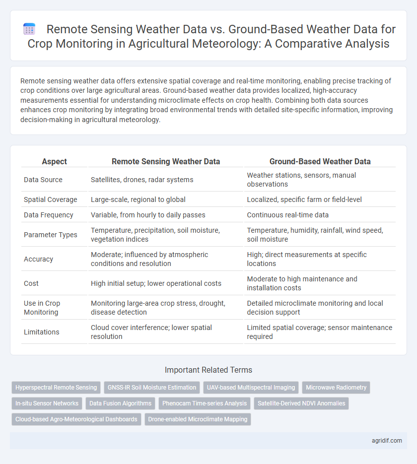
Remote sensing weather data offers extensive spatial coverage and real-time monitoring, enabling precise tracking of crop conditions over large agricultural areas. Ground-based weather data provides localized, high-accuracy measurements essential for understanding microclimate effects on crop health. Combining both data sources enhances crop monitoring by integrating broad environmental trends with detailed site-specific information, improving decision-making in agricultural meteorology.
Table of Comparison
| Aspect | Remote Sensing Weather Data | Ground-Based Weather Data |
|---|---|---|
| Data Source | Satellites, drones, radar systems | Weather stations, sensors, manual observations |
| Spatial Coverage | Large-scale, regional to global | Localized, specific farm or field-level |
| Data Frequency | Variable, from hourly to daily passes | Continuous real-time data |
| Parameter Types | Temperature, precipitation, soil moisture, vegetation indices | Temperature, humidity, rainfall, wind speed, soil moisture |
| Accuracy | Moderate; influenced by atmospheric conditions and resolution | High; direct measurements at specific locations |
| Cost | High initial setup; lower operational costs | Moderate to high maintenance and installation costs |
| Use in Crop Monitoring | Monitoring large-area crop stress, drought, disease detection | Detailed microclimate monitoring and local decision support |
| Limitations | Cloud cover interference; lower spatial resolution | Limited spatial coverage; sensor maintenance required |
Introduction to Weather Data in Crop Monitoring
Remote sensing weather data offers large-scale, real-time information on temperature, precipitation, and soil moisture critical for crop monitoring across extensive agricultural regions. Ground-based weather data provides localized, high-accuracy measurements from weather stations, enhancing precision in detecting microclimatic variations affecting crop growth. Integrating both data sources improves the accuracy of weather impact assessments and supports timely decision-making in precision agriculture.
Overview of Remote Sensing Weather Data
Remote sensing weather data utilizes satellite and aerial sensors to capture large-scale atmospheric and environmental parameters critical for crop monitoring, such as temperature, precipitation, and soil moisture, offering high spatial and temporal resolution. These data provide comprehensive coverage across inaccessible or vast agricultural regions, enhancing the precision of drought assessment, pest prediction, and yield forecasting. Integration with ground-based weather data improves accuracy by calibrating remote observations with localized measurements from weather stations and sensors in crop fields.
Fundamentals of Ground-Based Weather Data Collection
Ground-based weather data collection relies on instruments like anemometers, rain gauges, and thermometers installed at specific locations to provide precise, real-time measurements of temperature, humidity, wind speed, and precipitation essential for crop monitoring. This data is critical for understanding microclimate conditions affecting crop growth, enabling timely irrigation, pest control, and frost prevention tailored to localized environments. The accuracy and granularity of ground-based data complement remote sensing by validating satellite observations and improving crop yield predictions through site-specific weather analytics.
Data Accuracy: Remote Sensing vs Ground-Based Methods
Remote sensing weather data provides extensive spatial coverage critical for large-scale crop monitoring but often faces challenges in data accuracy due to atmospheric interference and sensor resolution limitations. Ground-based weather data offers high precision and temporal consistency through in situ measurements of temperature, humidity, and soil moisture, enabling detailed microclimate analysis essential for local crop management. Integrating both datasets enhances crop monitoring accuracy by leveraging the comprehensive scope of remote sensing with the localized precision of ground-based observations.
Spatial and Temporal Resolution Comparison
Remote sensing weather data provides extensive spatial coverage with high-resolution satellite imagery, enabling detailed monitoring of large agricultural areas, whereas ground-based weather data offers precise, localized measurements but limited spatial scope. In terms of temporal resolution, ground-based sensors deliver continuous, real-time data capturing minute-by-minute weather variations critical for timely crop management, while remote sensing data may have lower revisit frequencies depending on satellite orbits. Combining both sources enhances crop monitoring by leveraging wide-area spatial insights from remote sensing alongside high-frequency temporal updates from ground stations.
Cost and Accessibility Considerations
Remote sensing weather data offers broad spatial coverage at a relatively lower marginal cost, enabling frequent monitoring of large agricultural areas without the need for extensive physical infrastructure. Ground-based weather data, while typically highly accurate and localized, involves higher operational costs due to instrument installation, maintenance, and manual data collection, which may limit accessibility in remote or resource-constrained farming regions. Combining both data sources optimizes crop monitoring by balancing cost-efficiency and data resolution according to accessibility constraints and agricultural management needs.
Integration of Weather Data in Crop Growth Models
Remote sensing weather data offers extensive spatial coverage and high-frequency observations critical for capturing crop growth variability, while ground-based weather data provides precise, localized measurements essential for accurate model calibration. Integrating both data sources enhances crop growth models by increasing spatial accuracy and temporal resolution, improving predictions of phenological stages, stress factors, and yield outcomes. Combining satellite-derived atmospheric variables with in situ weather station data supports dynamic, site-specific agricultural decision-making and risk management.
Challenges and Limitations of Each Approach
Remote sensing weather data offers broad spatial coverage and frequent updates but faces challenges such as cloud cover interference, limited resolution for microclimate detection, and reliance on satellite availability. Ground-based weather data provides high accuracy and localized measurements essential for precise crop monitoring but is limited by sparse station distribution, maintenance costs, and potential data gaps during equipment failures. Combining both methods can mitigate individual limitations yet requires careful integration and calibration for optimal agricultural meteorology applications.
Case Studies: Real-world Applications in Agriculture
Remote sensing weather data, derived from satellite and aerial sensors, provides large-scale, continuous, and real-time monitoring of crop conditions, enabling precise assessment of drought, soil moisture, and pest outbreaks in diverse agricultural regions. Ground-based weather data, collected through local meteorological stations, offers high-resolution and accurate measurements of temperature, humidity, and rainfall essential for microclimate analysis and crop growth modeling. Case studies in precision agriculture demonstrate how integrating remote sensing with ground-based data improves yield prediction, irrigation management, and risk mitigation under varying climatic scenarios.
Future Trends in Crop Monitoring Technology
Remote sensing weather data offers extensive spatial coverage and real-time monitoring capabilities critical for large-scale crop health assessment, while ground-based weather data provides higher accuracy and localized insights essential for precise irrigation and pest management. Future trends in crop monitoring technology emphasize integrating multispectral satellite imagery with IoT-enabled ground sensors to enhance predictive analytics and decision-making accuracy. Advances in machine learning algorithms will optimize the fusion of these data sources, enabling dynamic, site-specific crop management strategies to improve yield forecasting and resource efficiency.
Related Important Terms
Hyperspectral Remote Sensing
Hyperspectral remote sensing captures detailed spectral signatures over large agricultural areas, enabling precise detection of crop health, nutrient status, and water stress compared to limited spatial coverage from ground-based weather stations. Integrating hyperspectral data with ground-based meteorological measurements enhances crop monitoring accuracy by providing comprehensive temporal and spatial weather information critical for precision agriculture.
GNSS-IR Soil Moisture Estimation
GNSS-IR soil moisture estimation leverages satellite signals to provide spatially extensive and continuous data, surpassing the localized coverage of ground-based sensors in crop monitoring. This remote sensing technique enhances the accuracy of agricultural meteorology by integrating soil moisture variability with meteorological parameters, improving irrigation management and yield prediction.
UAV-based Multispectral Imaging
UAV-based multispectral imaging enhances crop monitoring by providing high-resolution remote sensing weather data, capturing critical variables like soil moisture, canopy temperature, and vegetation indices with precise spatial and temporal granularity. Ground-based weather data complements this by offering accurate point measurements for parameters such as temperature, humidity, and wind speed, essential for validating and calibrating UAV multispectral sensors to improve predictive modeling in agricultural meteorology.
Microwave Radiometry
Microwave radiometry provides remote sensing weather data that penetrates cloud cover and vegetation, enabling accurate soil moisture and surface temperature measurements critical for crop monitoring. Ground-based weather data offers high temporal resolution and localized accuracy, but its spatial limitations are overcome by microwave radiometer satellites delivering comprehensive agricultural meteorology insights.
In-situ Sensor Networks
In-situ sensor networks provide high-resolution, localized ground-based weather data essential for accurate crop monitoring by capturing microclimate variations and soil moisture conditions directly within agricultural fields. Remote sensing weather data complements this by offering broader spatial coverage and temporal frequency, enabling large-scale analysis of crop health and stress factors, but may lack the fine-scale precision critical for site-specific agronomic decisions.
Data Fusion Algorithms
Data fusion algorithms integrate remote sensing weather data from satellites with ground-based weather data to enhance crop monitoring accuracy by combining spatial coverage and localized precision. These algorithms optimize predictive models by leveraging high-resolution satellite imagery and microclimatic ground sensor measurements, improving drought stress detection and yield forecasting in agricultural meteorology.
Phenocam Time-series Analysis
Phenocam time-series analysis leverages ground-based imagery to capture detailed crop phenological changes, providing high-resolution temporal data essential for precise crop monitoring. Remote sensing weather data complements this by offering broad spatial coverage of climatic variables such as temperature, precipitation, and solar radiation, enabling comprehensive assessment of crop growth conditions across diverse agricultural landscapes.
Satellite-Derived NDVI Anomalies
Satellite-derived NDVI anomalies provide large-scale, continuous monitoring of crop health by detecting vegetation stress and growth patterns not captured by ground-based weather data, which offer localized, high-resolution climate variables essential for precise crop modeling. Integrating satellite remote sensing with ground-based observations enhances agricultural meteorology accuracy in crop monitoring, improving early warning systems and yield prediction models.
Cloud-based Agro-Meteorological Dashboards
Remote sensing weather data offers extensive spatial coverage and real-time monitoring capabilities crucial for cloud-based agro-meteorological dashboards, enabling precise crop health assessment and targeted irrigation management. Ground-based weather data provides high-accuracy, localized measurements essential for validating remote sensing inputs and improving model reliability in crop monitoring systems.
Drone-enabled Microclimate Mapping
Drone-enabled microclimate mapping provides high-resolution remote sensing weather data crucial for precise crop monitoring by capturing localized variations in temperature, humidity, and soil moisture that traditional ground-based weather stations may miss. Integrating drone data with ground-based measurements enhances the accuracy of microclimate characterization, enabling optimized irrigation scheduling, pest management, and yield prediction in agricultural meteorology.
Remote sensing weather data vs Ground-based weather data for crop monitoring Infographic