Drones offer high-resolution, real-time data ideal for precise crop health assessment and targeted interventions, while satellite imagery provides broader coverage suitable for monitoring large-scale agricultural patterns over time. Drone technology excels in capturing detailed multispectral images that detect early signs of stress, pests, or disease, whereas satellites deliver consistent, multi-temporal datasets crucial for tracking seasonal variations and long-term trends. Integrating both technologies enhances decision-making by combining localized accuracy with expansive spatial insights in crop monitoring.
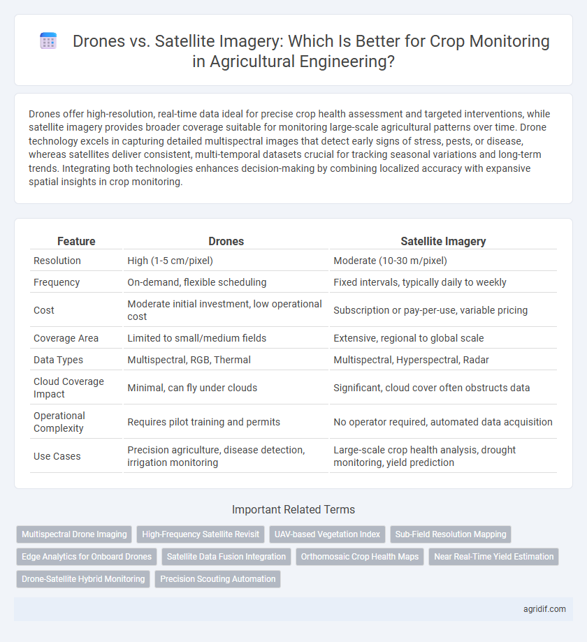
Table of Comparison
| Feature | Drones | Satellite Imagery |
|---|---|---|
| Resolution | High (1-5 cm/pixel) | Moderate (10-30 m/pixel) |
| Frequency | On-demand, flexible scheduling | Fixed intervals, typically daily to weekly |
| Cost | Moderate initial investment, low operational cost | Subscription or pay-per-use, variable pricing |
| Coverage Area | Limited to small/medium fields | Extensive, regional to global scale |
| Data Types | Multispectral, RGB, Thermal | Multispectral, Hyperspectral, Radar |
| Cloud Coverage Impact | Minimal, can fly under clouds | Significant, cloud cover often obstructs data |
| Operational Complexity | Requires pilot training and permits | No operator required, automated data acquisition |
| Use Cases | Precision agriculture, disease detection, irrigation monitoring | Large-scale crop health analysis, drought monitoring, yield prediction |
Introduction: Evolution of Remote Sensing in Agriculture
Drones and satellite imagery represent key advancements in remote sensing technology for agricultural engineering, enabling precise crop monitoring and enhancing yield prediction accuracy. Drones provide high-resolution, real-time data at the field level, facilitating timely interventions for pest control and irrigation management. Satellite imagery offers broader coverage and historical data analytics, supporting large-scale agricultural planning and resource allocation.
Overview of Drone Technology in Crop Monitoring
Drone technology in crop monitoring enables high-resolution, real-time data collection through multispectral, thermal, and RGB sensors, offering precise insights into plant health, soil conditions, and pest infestations. UAVs facilitate targeted interventions by capturing detailed imagery at lower altitudes than satellites, enhancing crop management efficiency. Advanced software integrates drone-collected data for predictive analytics, optimizing yield and resource allocation in modern agriculture.
Satellite Imagery: Capabilities and Advancements
Satellite imagery offers high-resolution, multispectral data essential for large-scale crop monitoring and precision agriculture. Advances in remote sensing technology enable real-time analysis of vegetation health, soil moisture, and pest infestations over extensive farming regions. The integration of AI and machine learning with satellite data enhances predictive analytics, optimizing crop management and improving yield forecasts.
Data Resolution: Drones vs Satellite Imagery
Drones provide ultra-high-resolution images with spatial details as fine as a few centimeters per pixel, enabling precise crop health assessment and early pest detection. Satellite imagery typically offers lower resolution, ranging from 10 to 30 meters per pixel, which is suitable for large-scale monitoring but may miss micro-level crop stress indicators. High-resolution drone data facilitates targeted interventions, enhancing yield optimization and resource efficiency compared to broader satellite data coverage.
Cost Analysis: Investment and Operational Expenses
Drones for crop monitoring typically require lower initial investment costs, ranging from $1,000 to $20,000 depending on the model and features, while satellite imagery subscriptions can cost between $5,000 and $30,000 annually. Operational expenses for drones include maintenance, pilot training, and data processing, whereas satellite imagery involves subscription fees and potential data acquisition delays, influencing overall cost-efficiency. Cost analysis favors drones for small to medium-sized farms due to their affordability and on-demand data collection, while satellite imagery suits large-scale operations benefiting from broad coverage despite higher recurring expenses.
Real-Time Monitoring: Speed and Frequency of Data
Drones provide higher-frequency, real-time crop monitoring with the ability to capture detailed images multiple times per day, enabling immediate detection of crop stress and pest infestations. Satellite imagery, though useful for large-scale agricultural analysis, often suffers from longer revisit times ranging from days to weeks, which limits its capacity for time-sensitive decision-making. The speed and data frequency of drones make them more effective for precise, timely interventions in crop management.
Accessibility and Coverage Area Considerations
Drones offer high-resolution, real-time crop monitoring with flexibility in targeted areas, making them highly accessible for individual farms or smaller plots. Satellite imagery covers extensive agricultural regions and provides consistent data across large-scale farms, but may have limitations in temporal resolution and availability during certain weather conditions. Balancing drone accessibility with satellite coverage area is crucial for optimizing precision agriculture and effective crop health assessment.
Precision Farming: Accuracy in Crop Health Assessment
Drones provide high-resolution, real-time images enabling precise detection of crop health issues, such as pest infestations and nutrient deficiencies, at the plant level. Satellite imagery covers larger areas but often lacks the spatial resolution and temporal frequency required for detailed, site-specific assessments crucial in precision farming. Integrating drone data with satellite imagery enhances accuracy in crop health monitoring, optimizing inputs and boosting yield outcomes.
Limitations and Challenges of Each Technology
Drones offer high-resolution, real-time crop monitoring but face limitations such as limited flight time, battery life, and restricted coverage area compared to satellite imagery. Satellite imagery provides extensive spatial coverage and frequent revisit times but suffers from lower spatial resolution, cloud cover interference, and longer data processing times. Both technologies require expertise in data interpretation and integration for effective decision-making in precision agriculture.
Future Trends: Integrating Drones and Satellite Imagery
Future trends in agricultural engineering highlight the integration of drones and satellite imagery for enhanced crop monitoring, combining the high-resolution, real-time data from drones with the wide-area coverage and temporal frequency of satellites. This synergy enables precision agriculture practices by providing comprehensive insights into crop health, soil conditions, and pest infestations. Advances in AI and machine learning further optimize data processing, facilitating more accurate yield predictions and resource management.
Related Important Terms
Multispectral Drone Imaging
Multispectral drone imaging offers higher spatial resolution and real-time data collection compared to satellite imagery, enabling precise crop health analysis and early stress detection. This technology captures multiple spectral bands, allowing detailed monitoring of vegetation indices like NDVI, which is crucial for optimizing irrigation, fertilization, and pest control in precision agriculture.
High-Frequency Satellite Revisit
High-frequency satellite revisit enables near-daily monitoring of crop health over vast agricultural areas, providing consistent temporal data critical for early disease detection and stress management. While drones offer higher spatial resolution and flexibility for localized inspections, satellite imagery's frequent pass intervals optimize large-scale crop surveillance and timely decision-making in precision agriculture.
UAV-based Vegetation Index
UAV-based vegetation indices offer higher spatial and temporal resolution for crop monitoring compared to satellite imagery, enabling precise detection of crop stress and variability within fields. These drones provide customizable flight paths and close-range data collection, enhancing the accuracy of NDVI, EVI, and other vegetation metrics critical for optimizing agricultural management.
Sub-Field Resolution Mapping
Drones provide superior sub-field resolution mapping compared to satellite imagery, enabling precise monitoring of crop health, stress detection, and nutrient variability at a centimeter-level scale. High-resolution drone data facilitates targeted interventions in precision agriculture, improving yield predictions and resource management beyond the meter-level resolution typical of most satellite images.
Edge Analytics for Onboard Drones
Drones equipped with edge analytics provide real-time crop monitoring by processing data onboard, enabling immediate decision-making and reducing latency compared to satellite imagery, which relies on delayed, cloud-based analysis. Edge analytics enhances precision agriculture by allowing drones to detect crop stress, pests, and nutrient deficiencies at high spatial resolution, improving timely interventions and crop yield optimization.
Satellite Data Fusion Integration
Satellite data fusion integration enhances crop monitoring by combining multi-spectral and temporal satellite imagery to deliver precise, large-scale agricultural insights that surpass the localized detail of drone data. This integration supports real-time decision-making through advanced analytics on soil health, crop stress, and yield prediction, optimizing resource use and improving overall farm management efficiency.
Orthomosaic Crop Health Maps
Drones provide high-resolution orthomosaic crop health maps with precise, localized data ideal for detecting early-stage stress, nutrient deficiencies, and pest infestations in agricultural fields, enabling targeted interventions. Satellite imagery offers broader coverage and frequent revisit times but generally delivers lower spatial resolution, making it less effective for detailed, field-level crop health analysis compared to drone-based orthomosaics.
Near Real-Time Yield Estimation
Drones equipped with high-resolution cameras provide detailed, near real-time crop data enabling precise yield estimation by capturing canopy health and growth variations at the plant level. Satellite imagery offers broader coverage for monitoring large agricultural areas but often lacks the frequency and spatial resolution necessary for timely, accurate yield predictions during critical growth stages.
Drone-Satellite Hybrid Monitoring
Drone-satellite hybrid monitoring combines the high-resolution, real-time data from drones with the extensive coverage and temporal frequency of satellite imagery, optimizing crop health assessments and precision agriculture practices. This integrated approach enhances the detection of stress factors, improves yield predictions, and supports efficient resource management by leveraging multispectral, hyperspectral, and thermal imaging data at multiple spatial scales.
Precision Scouting Automation
Drones provide high-resolution, real-time imagery enabling precise detection of crop health variations, pest infestations, and nutrient deficiencies, which enhances precision scouting automation with detailed data at a micro-level. Satellite imagery covers larger areas with less frequent updates and lower resolution, making drones more effective for timely and accurate precision agriculture decision-making.
Drones vs Satellite imagery for crop monitoring Infographic