GNSS provides reliable field mapping accuracy suitable for general precision agriculture tasks, but RTK significantly enhances positional accuracy by correcting satellite signal errors in real-time. RTK systems achieve centimeter-level precision, essential for applications requiring exact seed placement and variable rate fertilization. Choosing between GNSS and RTK depends on the required mapping accuracy and the scale of agricultural operations.
Table of Comparison
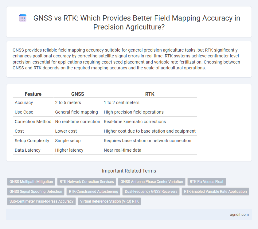
| Feature | GNSS | RTK |
|---|---|---|
| Accuracy | 2 to 5 meters | 1 to 2 centimeters |
| Use Case | General field mapping | High-precision field operations |
| Correction Method | No real-time correction | Real-time kinematic corrections |
| Cost | Lower cost | Higher cost due to base station and equipment |
| Setup Complexity | Simple setup | Requires base station or network connection |
| Data Latency | Higher latency | Near real-time data |
Introduction to GNSS and RTK in Precision Agriculture
Global Navigation Satellite Systems (GNSS) provide the foundational satellite-based positioning necessary for field mapping in precision agriculture, offering meter-level accuracy for general guidance. Real-Time Kinematic (RTK) technology enhances GNSS by using carrier phase measurements and correction signals from a base station, achieving centimeter-level accuracy crucial for tasks like variable rate application and planting. The integration of RTK with GNSS enables precise field mapping, improving crop management decisions and boosting overall farm productivity.
Understanding Field Mapping Accuracy Requirements
GNSS technology offers meter-level accuracy suitable for general field mapping, while RTK (Real-Time Kinematic) enhances precision to centimeter-level, critical for tasks demanding exact spatial data. Understanding field mapping accuracy requirements involves evaluating crop type, field size, and management goals to determine when RTK's high precision justifies its cost and complexity. Selecting the appropriate technology ensures optimal resource application and maximizes yield potential by aligning mapping accuracy with specific agricultural practices.
How GNSS Works for Agricultural Field Mapping
GNSS technology utilizes satellite signals to determine precise geographic coordinates, enabling accurate positioning for agricultural field mapping. Standard GNSS provides meter-level accuracy by triangulating signals from multiple satellites, which supports general field boundary delineation and crop monitoring. For enhanced precision, farmers often rely on RTK, which corrects GNSS data in real time to achieve centimeter-level accuracy, critical for tasks like variable rate application and detailed soil sampling.
RTK Technology: Enhancing GNSS Precision
RTK technology significantly enhances GNSS precision by correcting satellite signal errors in real-time, achieving centimeter-level accuracy critical for field mapping in precision agriculture. By leveraging a fixed base station and mobile receiver, RTK ensures accurate crop positioning, efficient input application, and optimized yield monitoring. This real-time correction reduces discrepancies inherent in standard GNSS, making RTK indispensable for precision farming operations requiring high spatial accuracy.
Accuracy Comparison: GNSS vs RTK in Field Mapping
RTK (Real-Time Kinematic) technology significantly enhances field mapping accuracy compared to standard GNSS by providing centimeter-level precision, essential for precise seed placement and variable rate application. GNSS systems typically offer meter-level accuracy, which may lead to less efficient crop management and increased input costs due to positional errors. Precision agriculture relies on RTK's enhanced accuracy to optimize resource usage and improve yield outcomes through detailed and reliable spatial data.
Cost and Accessibility: GNSS vs RTK Solutions
GNSS systems offer affordable and accessible field mapping solutions with accuracy typically within 2 to 5 meters, making them suitable for general agricultural applications. RTK technology enhances precision to centimeter-level accuracy but requires higher initial investment and ongoing costs for base stations or subscription services, limiting accessibility for smaller farms. Farmers balance cost constraints and mapping precision when choosing between GNSS and RTK, often opting for GNSS where budget limits dictate and RTK when exact field data improves yield outcomes.
Implementation Challenges in Agricultural Environments
GNSS systems provide reliable positioning but often struggle with accuracy fluctuations due to signal interference from dense crop canopies and varying terrain conditions common in agricultural environments. RTK technology enhances field mapping precision by delivering real-time corrections, yet its implementation faces challenges such as maintaining stable communication links and managing high initial setup costs for small to medium-sized farms. Overcoming these obstacles requires integrating robust hardware, optimizing base station placement, and ensuring continuous correction signal availability to achieve consistent accuracy in diverse field conditions.
Application Scenarios: When to Use GNSS or RTK
GNSS provides reliable positioning for large-scale field mapping with moderate accuracy requirements, making it suitable for general crop scouting and soil sampling. RTK delivers centimeter-level precision critical for tasks like planting, fertilizing, and variable-rate application where exact location data improves crop yield and resource efficiency. Selecting GNSS or RTK depends on field size, budget constraints, and required positional accuracy for specific agricultural applications.
Future Trends in Field Mapping Technologies
RTK (Real-Time Kinematic) technology offers centimeter-level accuracy by correcting GNSS (Global Navigation Satellite System) signals, enabling precise field mapping essential for precision agriculture. Future trends focus on integrating RTK with emerging technologies like multi-frequency GNSS, AI-driven data analysis, and satellite-based augmentation systems to enhance accuracy and reliability in dynamic agricultural environments. Advances in real-time data processing and cloud connectivity will further optimize decision-making, driving the evolution of smart farming practices.
Choosing the Right Technology for Precision Agriculture Needs
GNSS technology provides reliable field mapping accuracy with typical precision ranging from 1 to 3 meters, suitable for general agricultural applications. RTK enhances this precision significantly by offering centimeter-level accuracy, crucial for tasks like planting, fertilizing, and crop scouting where exact positioning matters. Selecting between GNSS and RTK depends on the specific precision requirements and budget constraints of the agricultural operation.
Related Important Terms
GNSS Multipath Mitigation
GNSS multipath mitigation techniques enhance the accuracy of standard GNSS receivers by reducing signal reflections that cause positioning errors, but they often fall short compared to Real-Time Kinematic (RTK) systems that deliver centimeter-level precision through differential corrections. For precision agriculture field mapping, RTK remains the preferred choice where high accuracy is critical, though advanced GNSS multipath mitigation can provide acceptable positioning improvements in less demanding applications.
RTK Network Correction Services
RTK Network Correction Services provide centimeter-level positional accuracy by integrating GNSS data with real-time differential corrections from multiple reference stations, significantly enhancing precision in field mapping over standard GNSS alone. These services optimize agricultural operations by enabling precise planting, irrigation, and resource management, reducing overlaps and gaps in coverage across varied terrain.
GNSS Antenna Phase Center Variation
GNSS antenna phase center variation (PCV) significantly impacts the positional accuracy in precision agriculture, as inconsistencies in signal reception lead to errors in field mapping. RTK (Real-Time Kinematic) systems mitigate these errors by providing real-time corrections that account for PCV, delivering centimeter-level accuracy essential for precise crop management.
RTK Fix Versus Float
RTK fix provides centimeter-level positioning accuracy for field mapping, essential for precision agriculture applications requiring exact data on crop and soil conditions. RTK float offers less precise positioning with meter-level accuracy, suitable for less demanding tasks but insufficient for high-precision field operations.
GNSS Signal Spoofing Detection
RTK technology enhances field mapping accuracy by utilizing real-time corrections to GNSS signals, significantly reducing positional errors compared to standalone GNSS systems. GNSS signal spoofing detection is crucial in precision agriculture to prevent false location data, ensuring the reliability of RTK-based mapping for precise crop monitoring and management.
RTK-Constrained Autosteering
RTK-Constrained Autosteering enhances field mapping accuracy by integrating Real-Time Kinematic (RTK) GNSS corrections, delivering centimeter-level positioning critical for precision agriculture tasks. This technology outperforms standard GNSS by minimizing positioning errors and improving machinery guidance, resulting in optimized input application and increased crop yields.
Dual-Frequency GNSS Receivers
Dual-frequency GNSS receivers enhance field mapping accuracy by simultaneously processing L1 and L2 signals, reducing ionospheric errors and improving positioning precision compared to single-frequency RTK systems. This advanced capability allows for more reliable and consistent measurements in precision agriculture, optimizing crop management and resource allocation.
RTK-Enabled Variable Rate Application
RTK (Real-Time Kinematic) technology significantly enhances field mapping accuracy by providing centimeter-level positional precision compared to standard GNSS systems, enabling precise variable rate applications in precision agriculture. RTK-enabled variable rate application optimizes input use, reduces waste, and improves crop yield by applying fertilizers or pesticides precisely where needed based on accurate site-specific field data.
Sub-Centimeter Pass-to-Pass Accuracy
RTK (Real-Time Kinematic) technology provides sub-centimeter pass-to-pass accuracy for field mapping by correcting GNSS (Global Navigation Satellite System) signals with real-time differential data from base stations, significantly reducing positional errors. This high-precision capability enables precise field operations, enhancing crop management decisions and optimizing resource application in precision agriculture.
Virtual Reference Station (VRS) RTK
Virtual Reference Station (VRS) RTK significantly enhances field mapping accuracy by providing real-time corrections via a network of base stations, reducing GNSS positional errors to centimeter-level precision. Unlike standalone GNSS, VRS RTK utilizes differential corrections to compensate for atmospheric and satellite signal inaccuracies, making it the preferred choice for precision agriculture applications requiring high spatial reliability.
GNSS vs RTK for field mapping accuracy Infographic