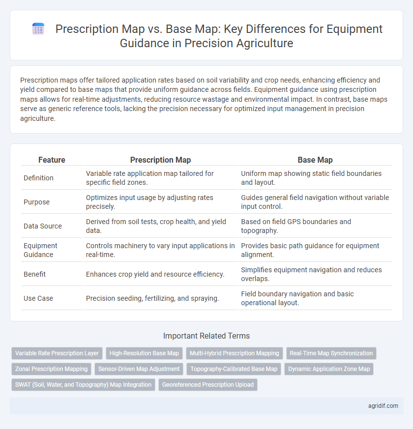
Prescription maps offer tailored application rates based on soil variability and crop needs, enhancing efficiency and yield compared to base maps that provide uniform guidance across fields. Equipment guidance using prescription maps allows for real-time adjustments, reducing resource wastage and environmental impact. In contrast, base maps serve as generic reference tools, lacking the precision necessary for optimized input management in precision agriculture.
Table of Comparison
| Feature | Prescription Map | Base Map |
|---|---|---|
| Definition | Variable rate application map tailored for specific field zones. | Uniform map showing static field boundaries and layout. |
| Purpose | Optimizes input usage by adjusting rates precisely. | Guides general field navigation without variable input control. |
| Data Source | Derived from soil tests, crop health, and yield data. | Based on field GPS boundaries and topography. |
| Equipment Guidance | Controls machinery to vary input applications in real-time. | Provides basic path guidance for equipment alignment. |
| Benefit | Enhances crop yield and resource efficiency. | Simplifies equipment navigation and reduces overlaps. |
| Use Case | Precision seeding, fertilizing, and spraying. | Field boundary navigation and basic operational layout. |
Understanding Prescription Maps in Precision Agriculture
Prescription maps in precision agriculture provide variable rate recommendations based on advanced data analysis, enabling precise application of inputs such as fertilizers, seeds, and pesticides. Unlike base maps, which primarily offer static field boundaries and general topography, prescription maps integrate soil variability, yield history, and real-time sensor data for optimized input application. This targeted guidance improves resource efficiency, crop yield, and environmental sustainability by tailoring equipment operations to specific field conditions.
Defining Base Maps for Equipment Guidance
Base maps for equipment guidance in precision agriculture serve as foundational spatial references that include field boundaries, roadways, and fixed landmarks essential for equipment navigation. These maps integrate GPS data and topographical information to ensure accurate positioning and movement of machinery within agricultural fields. Defining base maps with high-resolution imagery and terrain models enhances the precision of automated guidance systems, reducing overlap and optimizing field operations.
Key Differences: Prescription Maps vs Base Maps
Prescription maps in precision agriculture provide variable rate application instructions based on crop needs and soil conditions, while base maps serve as foundational geographic references without variable input data. Prescription maps integrate agronomic data such as nutrient requirements, pest pressure, and moisture levels, enabling equipment guidance systems to adjust field operations dynamically. Base maps typically include satellite imagery or field boundaries but lack the actionable, site-specific recommendations critical for precision equipment control.
Data Sources for Creating Prescription and Base Maps
Prescription maps in precision agriculture are created using diverse data sources such as soil sampling, crop health imagery from drones or satellites, yield data, and variable rate application data to customize field input applications. Base maps typically rely on GPS field boundaries, elevation models, and soil surveys to provide fundamental spatial references for equipment guidance. Integrating these data sources ensures precise machinery operations, enhancing resource efficiency and crop productivity.
Role of Prescription Maps in Variable Rate Application
Prescription maps play a crucial role in variable rate application by providing detailed, site-specific input recommendations based on soil variability and crop needs. These maps optimize resource use and improve crop yield by directing equipment to apply seeds, fertilizers, or pesticides at variable rates rather than a uniform base map. Compared to base maps, prescription maps enhance precision agriculture efficiency through data-driven, targeted application, reducing waste and environmental impact.
Base Maps and Their Importance in Equipment Navigation
Base maps serve as fundamental spatial references in precision agriculture, enabling accurate equipment navigation and field operations. These maps integrate geospatial data such as field boundaries, topography, and infrastructure, ensuring machinery follows optimal paths and reduces overlap or gaps during planting and spraying. Utilizing high-resolution base maps improves operational efficiency, decreases fuel consumption, and enhances crop management precision.
Accuracy and Resolution: Which Map Matters More?
Prescription maps prioritize high accuracy and variable resolution to tailor input applications precisely across field zones, enhancing crop yield and resource efficiency. Base maps provide foundational geographic accuracy and consistent resolution, essential for effective equipment guidance but lack the site-specific variability of prescription maps. For optimal equipment guidance in precision agriculture, prescription maps matter more due to their detailed, data-driven accuracy that directly informs variable rate technologies.
Integration with GPS and Autosteering Systems
Prescription maps provide variable rate application data essential for GPS-guided equipment, enabling precise input delivery tailored to specific field zones. Base maps offer fundamental geographical layouts but lack detailed agronomic prescriptions, limiting their effectiveness in advanced autosteering systems. Integrating prescription maps with GPS and autosteering enhances equipment guidance accuracy, optimizing input use and improving overall crop management efficiency.
Challenges and Best Practices in Map Implementation
Prescription maps in precision agriculture offer variable rate application based on field-specific data, whereas base maps provide uniform guidance across the entire field. Challenges in map implementation include ensuring data accuracy, integrating multiple data sources, and maintaining real-time equipment calibration to prevent application errors. Best practices involve regular map validation, leveraging high-resolution satellite or drone imagery, and continuous equipment-software compatibility checks to optimize input efficiency and crop yield.
Future Trends in Mapping Technologies for Precision Agriculture
Future trends in mapping technologies for precision agriculture emphasize the integration of real-time data analytics and AI-driven algorithms to enhance Prescription Maps, enabling highly variable rate applications with unprecedented accuracy. Advances in multispectral and hyperspectral imaging combined with satellite and drone data promise to refine Base Maps, improving soil and crop health assessments for more precise equipment guidance. The convergence of cloud computing and IoT sensors will facilitate dynamic, adaptive mapping solutions that optimize resource use and increase overall farm productivity.
Related Important Terms
Variable Rate Prescription Layer
The Variable Rate Prescription Layer in Precision Agriculture enables equipment guidance systems to apply inputs with field-specific precision, optimizing resource use and crop yield. Unlike Base Maps, which provide static field boundaries and general layouts, Prescription Maps integrate real-time agronomic data to generate customized input application patterns for variable rate technology machinery.
High-Resolution Base Map
High-resolution base maps provide detailed spatial information essential for precise equipment guidance, enabling accurate field navigation and operational efficiency in precision agriculture. Prescription maps, while tailored for variable rate applications, rely on the foundational accuracy of high-resolution base maps to optimize input placement and crop management strategies.
Multi-Hybrid Prescription Mapping
Multi-hybrid prescription mapping enhances precision agriculture by creating variable-rate seeding prescriptions based on field variability, contrasting base maps that provide uniform equipment guidance without site-specific adjustments. This approach optimizes yield potential and input efficiency by integrating genetic traits and soil data for tailored seeding strategies across different field zones.
Real-Time Map Synchronization
Prescription maps dynamically update soil variability and crop health data to provide real-time map synchronization for precise equipment guidance, enhancing variable rate application accuracy. Base maps serve as static references with foundational geospatial information but lack the live data integration necessary for adapting machinery operations during fieldwork.
Zonal Prescription Mapping
Prescription maps in precision agriculture provide variable rate recommendations based on specific field zones identified through soil data, crop health, and yield variability, enabling targeted input application. Base maps serve as static guides showing field boundaries and fixed features but lack the dynamic, zone-specific data necessary for optimizing equipment guidance and maximizing resource efficiency.
Sensor-Driven Map Adjustment
Prescription maps utilize sensor-driven data to dynamically adjust application rates in real-time, enhancing crop yield and resource efficiency by tailoring inputs to precise field conditions. Base maps serve as static references for equipment guidance, lacking the adaptive capabilities of sensor-informed prescription maps that respond to spatial variability detected through advanced agronomic sensors.
Topography-Calibrated Base Map
Topography-calibrated base maps enhance equipment guidance by integrating elevation and slope data, enabling precise navigation and reduced soil compaction across varied terrains. These maps provide foundational spatial accuracy, while prescription maps layer variable rate input instructions for optimized resource application efficiency.
Dynamic Application Zone Map
A Prescription Map in precision agriculture dynamically adjusts application rates based on real-time field data, enhancing input efficiency and crop yield compared to a static Base Map, which provides uniform guidance without accounting for spatial variability. Dynamic Application Zone Maps integrate sensor data and variable rate technology to create precise, site-specific management zones, optimizing resource use and minimizing environmental impact.
SWAT (Soil, Water, and Topography) Map Integration
Prescription maps leverage SWAT (Soil, Water, and Topography) data to tailor equipment guidance for optimal input application, enhancing resource efficiency and crop yield. Base maps provide general field boundaries and fixed landmarks without integrating SWAT data, limiting their precision in addressing soil variability and water management for equipment navigation.
Georeferenced Prescription Upload
Georeferenced prescription maps optimize equipment guidance by enabling precise variable-rate applications directly linked to spatial data, while base maps serve as static references without embedded treatment instructions. Uploading georeferenced prescriptions ensures accurate, site-specific management, improving input efficiency and crop yield compared to generic base maps.
Prescription Map vs Base Map for Equipment Guidance Infographic