Yield mapping provides precise, field-level data on crop productivity by collecting harvest information directly from machinery, enabling farmers to identify high- and low-yield zones for targeted management. Remote sensing utilizes satellite or drone imagery to monitor crop health, detect stress, and assess variability over time through multispectral or hyperspectral data. Combining yield mapping with remote sensing enhances precision agriculture by offering both spatial yield data and real-time crop condition insights, optimizing decision-making for improved productivity.
Table of Comparison
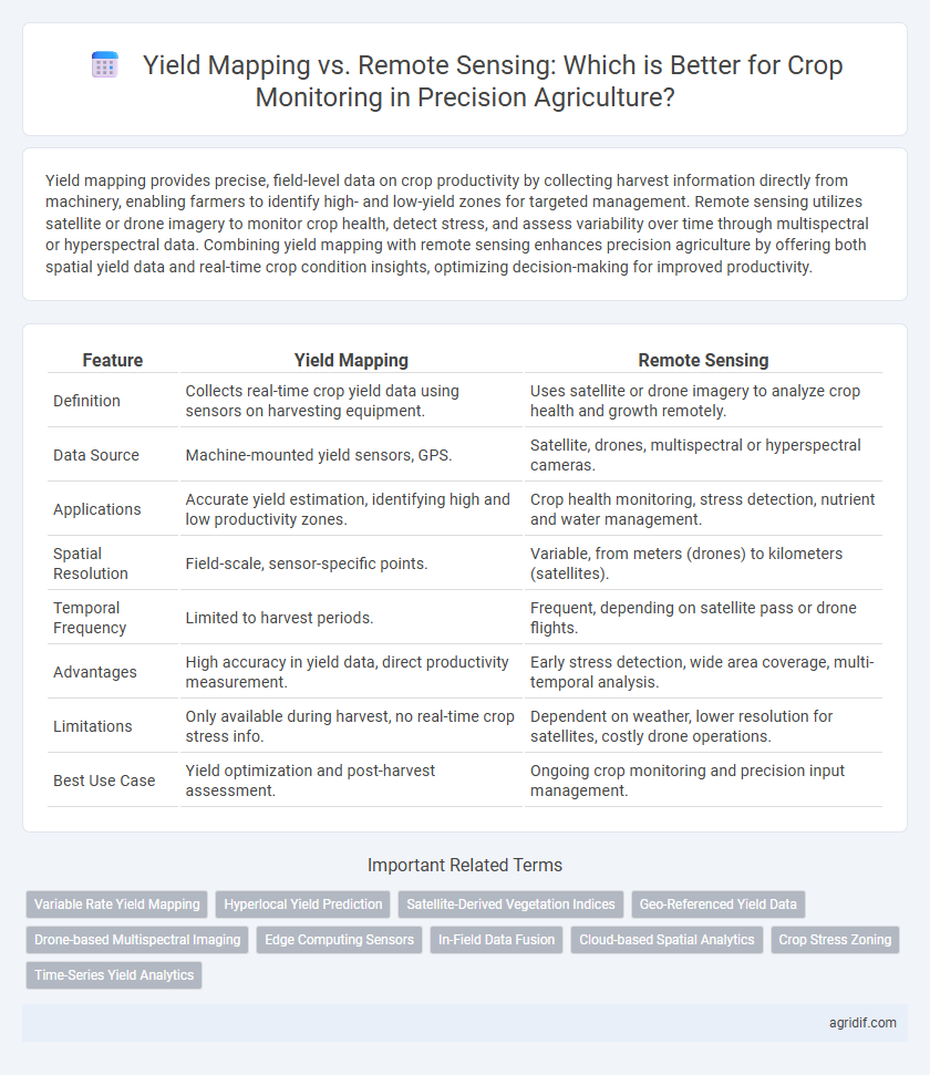
| Feature | Yield Mapping | Remote Sensing |
|---|---|---|
| Definition | Collects real-time crop yield data using sensors on harvesting equipment. | Uses satellite or drone imagery to analyze crop health and growth remotely. |
| Data Source | Machine-mounted yield sensors, GPS. | Satellite, drones, multispectral or hyperspectral cameras. |
| Applications | Accurate yield estimation, identifying high and low productivity zones. | Crop health monitoring, stress detection, nutrient and water management. |
| Spatial Resolution | Field-scale, sensor-specific points. | Variable, from meters (drones) to kilometers (satellites). |
| Temporal Frequency | Limited to harvest periods. | Frequent, depending on satellite pass or drone flights. |
| Advantages | High accuracy in yield data, direct productivity measurement. | Early stress detection, wide area coverage, multi-temporal analysis. |
| Limitations | Only available during harvest, no real-time crop stress info. | Dependent on weather, lower resolution for satellites, costly drone operations. |
| Best Use Case | Yield optimization and post-harvest assessment. | Ongoing crop monitoring and precision input management. |
Introduction to Precision Agriculture Technologies
Yield mapping provides high-resolution, field-specific data by measuring crop yield variations directly during harvest through GPS-equipped combines, enabling precise nutrient and irrigation management. Remote sensing utilizes satellite or drone imagery to monitor crop health indicators such as NDVI, soil moisture, and pest infestations over large areas, offering real-time insights for timely decision-making. Combining yield mapping and remote sensing enhances overall crop monitoring accuracy, optimizing resource use and increasing agricultural productivity in precision agriculture systems.
Understanding Yield Mapping: Definition and Process
Yield mapping involves collecting GPS-referenced data on crop yield and quality using combine harvesters equipped with sensors, which allows precise spatial analysis of field variability. The process integrates real-time measurement of yield components such as grain moisture, weight, and flow rate, facilitating detailed mapping of productivity patterns across fields. This data enables farmers to optimize input application by identifying high and low yield zones, ultimately increasing efficiency and crop performance in precision agriculture.
What is Remote Sensing in Crop Monitoring?
Remote sensing in crop monitoring involves using satellite or drone-mounted sensors to collect data on crop health, soil conditions, and moisture levels across large agricultural fields. This technology captures spectral information beyond human vision, enabling early detection of stress factors like pests, diseases, and nutrient deficiencies. Compared to yield mapping, which records harvested crop output, remote sensing provides real-time, spatially detailed insights critical for proactive farm management in precision agriculture.
Data Collection Methods: Yield Mapping vs Remote Sensing
Yield mapping collects precise harvest data directly from combines equipped with GPS and sensors, capturing real-time variations in crop yield across fields. Remote sensing uses satellite or drone imagery to monitor crop health and stress by analyzing spectral data, allowing for large-scale, non-invasive observation. Combining both methods enhances decision-making by providing detailed ground-level yield data alongside broader spatial crop condition insights.
Spatial Resolution: Comparing Yield Maps and Remote Sensing Imagery
Yield mapping offers high spatial resolution by capturing precise, field-level data directly from harvesters, enabling detailed analysis of crop performance variations within small plots. Remote sensing imagery provides broader coverage with varying spatial resolutions depending on the sensor, ranging from sub-meter drone images to satellite data with resolutions up to 30 meters, suitable for regional crop health assessment. Combining yield maps' fine-scale data with the extensive spatial scope of remote sensing enhances comprehensive crop monitoring and decision-making in precision agriculture.
Temporal Accuracy: Real-Time Monitoring Capabilities
Yield mapping provides precise, field-level data on crop performance during harvest, enabling farmers to analyze spatial variability post-season. Remote sensing offers real-time monitoring through satellite or drone imagery, capturing dynamic crop conditions and stress indicators throughout the growing season. Temporal accuracy is higher with remote sensing, facilitating timely management decisions to optimize inputs and improve crop health.
Data Integration and Analysis in Precision Agriculture
Yield mapping captures spatially explicit harvest data directly from combines, providing high-resolution, real-time insights into crop performance variations within fields. Remote sensing complements yield mapping by offering multispectral and temporal data from satellites or drones, enabling early detection of crop stress, pest infestations, and nutrient deficiencies. Integrating yield mapping with remote sensing data through advanced analytics and machine learning enhances precision agriculture decision-making by delivering comprehensive, multi-source datasets that improve accuracy, predictive capabilities, and targeted interventions.
Cost Efficiency: Equipment and Operational Expenses
Yield mapping uses GPS-equipped combine harvesters to collect precise data on crop yield in real-time, offering cost efficiency through direct measurement with existing machinery, minimizing additional operational expenses. Remote sensing requires investment in drones, satellites, or aircraft for data acquisition and specialized software for analysis, resulting in higher upfront and maintenance costs but wider spatial coverage. Balancing equipment costs and operational expenses depends on farm size and monitoring frequency, with yield mapping being more affordable for continuous, localized data and remote sensing suited for extensive area assessments.
Practical Applications: Case Studies and Success Stories
Yield mapping and remote sensing serve complementary roles in precision agriculture by providing detailed spatial data for crop monitoring. Case studies demonstrate that yield mapping, through GPS-enabled combines, enables farmers to identify within-field variability and optimize inputs like fertilizers, leading to increased productivity and cost savings. Remote sensing, utilizing satellite or drone imagery, offers real-time crop health assessments and stress detection, with success stories highlighting improved irrigation management and early pest identification.
Choosing the Right Technology: Key Factors for Farmers
Yield mapping provides precise, field-specific data on crop production, enabling farmers to identify high- and low-yield zones for optimized input application. Remote sensing offers broader coverage with multispectral imaging to monitor crop health, moisture levels, and stress indicators across large areas. Farmers should consider factors such as field size, budget, data resolution needs, and desired monitoring frequency to select the most effective technology for their specific crop management goals.
Related Important Terms
Variable Rate Yield Mapping
Variable Rate Yield Mapping offers precise, georeferenced data enabling tailored nutrient and irrigation applications, enhancing crop productivity by responding to field variability. Remote Sensing complements this by providing real-time aerial imagery and spectral analysis to detect crop health and stress but lacks the granular, site-specific yield data essential for accurate variable rate adjustments.
Hyperlocal Yield Prediction
Yield mapping provides hyperlocal yield prediction by collecting precise in-field data through combine harvesters equipped with GPS and sensors, enabling accurate assessment of spatial yield variability. Remote sensing complements this by offering broader spectral data from satellites or drones, but yield mapping delivers finer resolution insights crucial for targeted crop management decisions.
Satellite-Derived Vegetation Indices
Yield mapping provides detailed, field-specific productivity data by recording actual crop output during harvest, while remote sensing using satellite-derived vegetation indices such as NDVI and EVI offers real-time, large-scale monitoring of crop health and biomass variability. Satellite data enables early detection of stress factors and spatial variability across fields, enhancing decision-making for precision agriculture by complementing yield maps with timely vegetation condition insights.
Geo-Referenced Yield Data
Geo-referenced yield data provides precise spatial information on crop productivity, enabling farmers to identify variability within fields and optimize inputs accordingly. Remote sensing complements this by offering timely vegetation and soil health insights, but yield mapping delivers granular, harvest-specific metrics essential for targeted decision-making in precision agriculture.
Drone-based Multispectral Imaging
Yield mapping provides precise spatial data on crop output variations using harvesters equipped with sensors, while drone-based multispectral imaging in remote sensing captures real-time plant health indicators such as NDVI and chlorophyll levels. Integrating drone multispectral data enhances crop monitoring by enabling early detection of stress, nutrient deficiencies, and pest infestations, allowing for targeted interventions and optimized farm management.
Edge Computing Sensors
Yield mapping utilizes edge computing sensors to collect precise, real-time data on crop productivity directly from the field, enabling immediate analysis and decision-making. Remote sensing complements this by capturing wide-area crop health images from drones or satellites, but edge computing sensors enhance the accuracy and speed of localized monitoring essential for precision agriculture.
In-Field Data Fusion
Yield mapping provides precise harvest data that quantifies crop output variability within fields, while remote sensing offers spatially extensive, multispectral insights into crop health and stress indicators. Integrating in-field data fusion from yield mapping and remote sensing enhances decision-making by combining ground-level yield variability with aerial or satellite-derived vegetation indices for comprehensive crop monitoring and management.
Cloud-based Spatial Analytics
Yield mapping provides precise, field-level data on crop output by utilizing GPS and harvest sensor technology, enabling accurate analysis of spatial variability in productivity. Cloud-based spatial analytics enhance remote sensing by processing large-scale satellite and drone imagery in real-time, offering timely insights into crop health, stress detection, and resource management for precision agriculture.
Crop Stress Zoning
Yield mapping provides precise, field-specific data on crop performance by analyzing harvest output, enabling targeted identification of stress zones with spatial accuracy. Remote sensing uses multispectral and hyperspectral imagery to detect real-time physiological crop stress, offering dynamic monitoring of crop health and early stress detection for optimized intervention.
Time-Series Yield Analytics
Time-series yield analytics leverage yield mapping data to provide high-resolution, field-specific crop performance insights over multiple seasons, enabling precise identification of yield variability and temporal trends. In contrast, remote sensing offers broader spatial coverage and real-time vegetation indices but often lacks the granular, cumulative yield data necessary for detailed, year-over-year productivity assessments.
Yield Mapping vs Remote Sensing for crop monitoring Infographic