Ground-based sensors provide continuous, high-resolution data on soil moisture, nutrient levels, and microclimate conditions, enabling precise monitoring of crop health at the root level. Aerial drones offer rapid, wide-area imaging and multispectral analysis, capturing real-time data on canopy health and identifying stress patterns across large fields. Combining these technologies enhances data accuracy and decision-making, optimizing crop yield and resource management in precision agriculture.
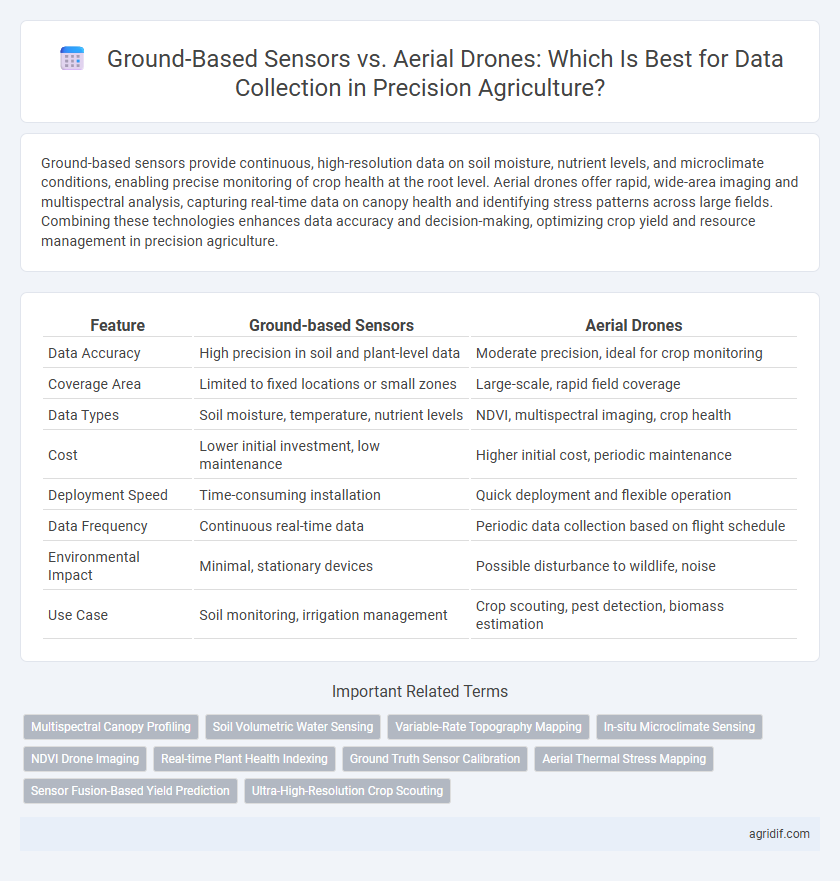
Table of Comparison
| Feature | Ground-based Sensors | Aerial Drones |
|---|---|---|
| Data Accuracy | High precision in soil and plant-level data | Moderate precision, ideal for crop monitoring |
| Coverage Area | Limited to fixed locations or small zones | Large-scale, rapid field coverage |
| Data Types | Soil moisture, temperature, nutrient levels | NDVI, multispectral imaging, crop health |
| Cost | Lower initial investment, low maintenance | Higher initial cost, periodic maintenance |
| Deployment Speed | Time-consuming installation | Quick deployment and flexible operation |
| Data Frequency | Continuous real-time data | Periodic data collection based on flight schedule |
| Environmental Impact | Minimal, stationary devices | Possible disturbance to wildlife, noise |
| Use Case | Soil monitoring, irrigation management | Crop scouting, pest detection, biomass estimation |
Introduction: Evolution of Data Collection in Precision Agriculture
Ground-based sensors and aerial drones represent two pivotal advancements in precision agriculture data collection, each offering distinct advantages in accuracy and coverage. Ground-based sensors provide real-time soil moisture, nutrient levels, and microclimate data with high spatial resolution, enabling targeted field management. Aerial drones, equipped with multispectral and thermal cameras, capture expansive crop health and stress indicators from above, accelerating decision-making through comprehensive aerial surveys.
Ground-Based Sensors: Types and Key Applications
Ground-based sensors in precision agriculture include soil moisture probes, nutrient sensors, and canopy analyzers, offering real-time, highly accurate data on crop health and soil conditions. These sensors enable precise irrigation management, nutrient application, and pest detection, optimizing resource use while minimizing environmental impact. Their fixed location ensures continuous monitoring, making them indispensable for localized crop and soil management strategies.
Aerial Drones: Technology Overview and Capabilities
Aerial drones equipped with multispectral, thermal, and RGB cameras deliver high-resolution imagery and real-time data for precision agriculture, enabling precise crop monitoring and stress detection. Advanced flight control systems and GPS integration allow drones to cover large fields efficiently, capturing detailed plant health metrics and soil variability. These capabilities enhance decision-making processes by providing actionable insights on irrigation, fertilization, and pest management with unprecedented accuracy.
Data Accuracy: Ground Sensors vs Aerial Drones
Ground-based sensors provide high-resolution, localized data with precise measurements of soil moisture, temperature, and nutrient levels, enhancing data accuracy at specific points. Aerial drones, while covering larger areas efficiently, may face limitations in data precision due to factors such as altitude, sensor calibration, and environmental conditions. Combining both methods can optimize data accuracy by leveraging the detailed granularity of ground sensors and the broad coverage of aerial drones in precision agriculture.
Spatial Coverage and Scalability Analysis
Ground-based sensors provide high-resolution, localized data but are limited in spatial coverage and scalability due to fixed deployment and maintenance challenges. Aerial drones offer extensive spatial coverage and flexible scalability, enabling rapid data collection across large agricultural fields with adjustable flight paths and sensor payloads. The choice between technologies depends on the balance between detailed site-specific monitoring needs and broader area analysis efficiency.
Real-Time Monitoring: Response Speed and Efficiency
Ground-based sensors provide continuous, real-time monitoring of soil moisture, nutrient levels, and crop health with high precision, enabling immediate response to environmental changes. Aerial drones complement this by offering rapid, large-area surveillance that detects crop stress and pest infestations from above, significantly enhancing data collection efficiency. Integrating both technologies optimizes response speed and operational efficiency in precision agriculture, ensuring timely interventions and maximizing yields.
Cost Comparison: Initial Investment and Maintenance
Ground-based sensors in precision agriculture involve lower initial investment costs compared to aerial drones, which require expensive hardware and software integration. Maintenance expenses for ground sensors are generally minimal, involving occasional calibration and replacements, while drones demand regular servicing, battery replacements, and software updates, increasing their overall operational costs. Farmers must weigh the trade-off between the affordability of ground sensors and the advanced data collection capabilities of aerial drones when budgeting for precision agriculture technology.
Integration with Farm Management Systems
Ground-based sensors offer continuous, real-time data integration with farm management systems, enabling precise monitoring of soil moisture, nutrient levels, and crop health at the root zone. Aerial drones complement this by providing high-resolution, multispectral imaging for large-scale crop assessments and rapid anomaly detection across expansive fields. Combining both technologies enhances data accuracy and decision-making efficiency in precision agriculture through seamless integration with digital farm management platforms.
Limitations and Challenges of Each Method
Ground-based sensors provide high-resolution data and continuous monitoring but face challenges such as limited spatial coverage and installation costs. Aerial drones offer extensive area surveys and rapid data acquisition but encounter restrictions including battery life, weather dependency, and regulatory compliance. Both methods require integration of data management systems to overcome connectivity and processing limitations for effective precision agriculture applications.
Future Trends: Combining Ground Sensors and Aerial Drones
Integrating ground-based sensors with aerial drones enhances precision agriculture by providing complementary data sets, enabling more accurate crop health monitoring and soil analysis. Future trends indicate increased use of AI-driven platforms that synthesize multispectral and environmental data from both sources, improving decision-making for irrigation and fertilization. This hybrid approach maximizes spatial and temporal resolution, driving higher yields and sustainable farming practices.
Related Important Terms
Multispectral Canopy Profiling
Ground-based sensors provide high-resolution multispectral canopy profiling with precise spatial accuracy ideal for detailed plant health analysis, while aerial drones cover larger areas quickly, capturing multispectral data useful for monitoring crop variability and identifying stress patterns across extensive fields. Integrating both technologies enhances precision agriculture by combining detailed ground-level insights with broad aerial perspectives for comprehensive crop management.
Soil Volumetric Water Sensing
Ground-based sensors provide precise real-time measurements of soil volumetric water content at multiple depths, enabling accurate irrigation management and crop health monitoring. Aerial drones offer rapid, high-resolution spatial mapping of soil moisture variability across large fields but lack the continuous depth-specific data available from in-situ sensors.
Variable-Rate Topography Mapping
Ground-based sensors provide high-resolution, real-time data for variable-rate topography mapping, enabling precise soil and crop condition monitoring at specific field points. Aerial drones cover larger areas quickly, capturing multispectral and topographic data that enhances spatial variability analysis critical for tailored intervention strategies in precision agriculture.
In-situ Microclimate Sensing
Ground-based sensors provide highly accurate in-situ microclimate data by directly measuring soil moisture, temperature, and humidity at root level, enabling precise localized monitoring for crop health management. Aerial drones cover larger areas rapidly with moderate resolution but may miss fine-scale spatial variability critical for immediate decision-making in microclimate-sensitive crop zones.
NDVI Drone Imaging
Ground-based sensors provide precise, localized data on soil moisture and crop health but are limited in coverage compared to aerial drones, which utilize NDVI drone imaging to deliver extensive, high-resolution vegetation indices across large agricultural fields. NDVI drone imaging optimizes crop monitoring by detecting plant stress and growth variability, enabling targeted interventions that enhance yield and resource efficiency.
Real-time Plant Health Indexing
Ground-based sensors provide continuous, high-resolution data for real-time plant health indexing by directly monitoring soil moisture, nutrient levels, and microclimate variables at the crop canopy level. Aerial drones offer rapid, large-scale imaging with multispectral and thermal cameras to detect plant stress indicators and disease outbreaks, enabling efficient spatial analysis across extensive farmlands.
Ground Truth Sensor Calibration
Ground-based sensors provide accurate ground truth data essential for calibrating aerial drone imagery, ensuring precise measurement of soil moisture, nutrient levels, and crop health in precision agriculture. Integrating sensor data with drone-based remote sensing enhances crop monitoring accuracy by aligning aerial observations with validated ground conditions.
Aerial Thermal Stress Mapping
Aerial drones equipped with thermal sensors enable high-resolution stress mapping across extensive agricultural fields, detecting crop water deficits and heat stress more rapidly and accurately than ground-based sensors. This airborne thermal imaging technology facilitates precise irrigation management and early intervention, optimizing crop yield and resource efficiency.
Sensor Fusion-Based Yield Prediction
Ground-based sensors provide high-resolution soil and crop data, while aerial drones capture extensive field imagery, enabling comprehensive sensor fusion for accurate yield prediction in precision agriculture. Integrating multispectral drone data with in-situ sensor measurements enhances predictive models by combining spatial depth and temporal accuracy, driving optimized crop management decisions.
Ultra-High-Resolution Crop Scouting
Ground-based sensors provide ultra-high-resolution crop scouting by capturing precise, detailed data at the plant level, enabling accurate nutrient and moisture monitoring. Aerial drones complement this by covering larger areas rapidly while delivering multispectral and thermal imaging, enhancing spatial analysis for crop health assessment.
Ground-based Sensors vs Aerial Drones for data collection Infographic