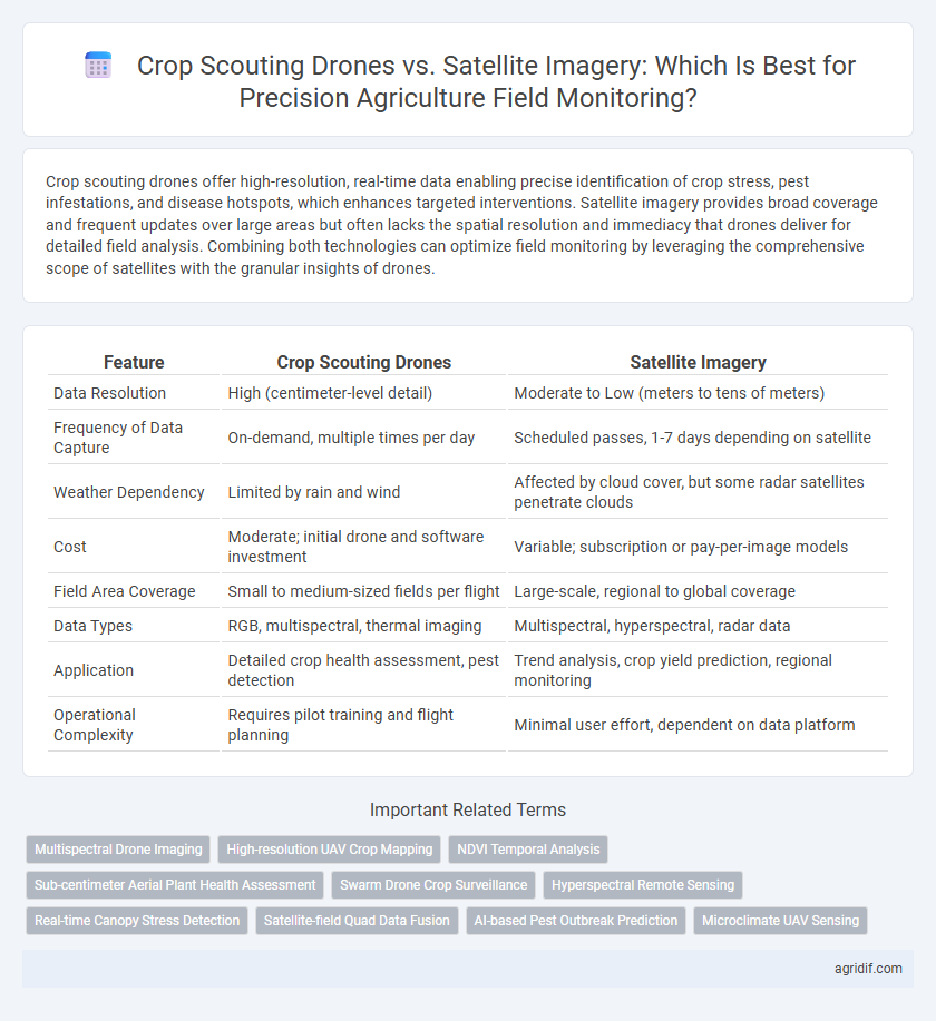
Crop scouting drones offer high-resolution, real-time data enabling precise identification of crop stress, pest infestations, and disease hotspots, which enhances targeted interventions. Satellite imagery provides broad coverage and frequent updates over large areas but often lacks the spatial resolution and immediacy that drones deliver for detailed field analysis. Combining both technologies can optimize field monitoring by leveraging the comprehensive scope of satellites with the granular insights of drones.
Table of Comparison
| Feature | Crop Scouting Drones | Satellite Imagery |
|---|---|---|
| Data Resolution | High (centimeter-level detail) | Moderate to Low (meters to tens of meters) |
| Frequency of Data Capture | On-demand, multiple times per day | Scheduled passes, 1-7 days depending on satellite |
| Weather Dependency | Limited by rain and wind | Affected by cloud cover, but some radar satellites penetrate clouds |
| Cost | Moderate; initial drone and software investment | Variable; subscription or pay-per-image models |
| Field Area Coverage | Small to medium-sized fields per flight | Large-scale, regional to global coverage |
| Data Types | RGB, multispectral, thermal imaging | Multispectral, hyperspectral, radar data |
| Application | Detailed crop health assessment, pest detection | Trend analysis, crop yield prediction, regional monitoring |
| Operational Complexity | Requires pilot training and flight planning | Minimal user effort, dependent on data platform |
Introduction to Precision Agriculture Technologies
Crop scouting drones offer high-resolution, real-time aerial imagery that enables precise detection of crop health issues, pest infestations, and nutrient deficiencies at a granular level. Satellite imagery provides broader, large-scale field monitoring with multispectral data useful for tracking overall crop conditions, moisture levels, and growth patterns across extensive agricultural areas. Integrating drone data with satellite imagery enhances decision-making accuracy in precision agriculture by combining localized detail and extensive coverage.
Understanding Crop Scouting Drones
Crop scouting drones offer high-resolution, real-time data that allows precise identification of crop stress, pest infestations, and nutrient deficiencies at the individual plant level. Unlike satellite imagery, drones can operate under cloud cover and provide flexible flight schedules tailored to specific monitoring needs. Their integration with multispectral and thermal sensors enhances actionable insights, promoting timely interventions and improving crop yield efficiency.
Overview of Satellite Imagery in Agriculture
Satellite imagery in agriculture provides extensive time-series data essential for monitoring crop health, soil moisture, and nutrient levels across large fields. Its high revisit frequency and multispectral imaging capabilities enable precise detection of stress patterns and disease outbreaks at early stages. Compared to crop scouting drones, satellites offer broader spatial coverage and integration with weather data, enhancing decision-making in precision agriculture.
Data Resolution: Drones vs Satellite Imagery
Crop scouting drones provide ultra-high-resolution images with centimeter-level accuracy, enabling detailed analysis of crop health, pest infestation, and nutrient deficiencies. Satellite imagery offers broader field coverage but typically with lower spatial resolution, often ranging from 10 to 30 meters per pixel, which may miss fine-scale variations crucial for precision interventions. The superior data resolution of drones allows for more precise and timely decision-making in crop management compared to the coarser detail captured by satellites.
Frequency of Data Collection and Real-Time Monitoring
Crop scouting drones enable high-frequency data collection with real-time monitoring capabilities, capturing detailed field conditions multiple times per day. Satellite imagery, while offering broader spatial coverage, is limited by orbital schedules and weather conditions, reducing its frequency and immediacy. The superior temporal resolution of drones supports proactive decision-making for precision agriculture, improving crop health management and yield predictions.
Cost Considerations: Investment and Operation
Crop scouting drones require a higher initial investment for purchasing and maintenance compared to satellite imagery, which is often accessed through subscription services. Operating drones involves ongoing costs such as battery replacement, pilot training, and software updates, while satellite imagery expenses primarily depend on data resolution and frequency. Cost efficiency varies with farm size and monitoring needs, where drones offer detailed, on-demand data at a higher operational cost, and satellite imagery provides broader coverage with lower recurring expenses.
Accuracy in Field Variability Detection
Crop scouting drones offer superior accuracy in detecting field variability compared to satellite imagery by capturing high-resolution, real-time data at a plant-level scale. Satellite imagery, while useful for broad monitoring, often struggles with lower spatial resolution and atmospheric interference, limiting its effectiveness in precise field variability detection. Drones enable targeted interventions through detailed, timely insights into crop health and stress patterns.
Accessibility and Usability for Farmers
Crop scouting drones offer farmers real-time, high-resolution field data with greater accessibility by allowing targeted monitoring of specific areas, even in remote locations. Unlike satellite imagery, which can be limited by cloud cover and low revisit frequency, drones provide flexible, on-demand usage without requiring extensive technical expertise. This ease of deployment and detailed data capture enhances usability, enabling farmers to quickly identify crop health issues and optimize field management.
Integration with Farm Management Systems
Crop scouting drones provide high-resolution, real-time data that seamlessly integrates with farm management systems, enabling precise monitoring of crop health and immediate decision-making. Satellite imagery offers broader, periodic field coverage with lower resolution but enhances trend analysis when combined with historical farm data. Integrating both technologies delivers comprehensive insights, optimizing resource allocation and crop yield predictions within digital agriculture platforms.
Choosing the Right Solution: Factors to Consider
Crop scouting drones offer high-resolution, real-time imagery ideal for detecting pest infestations and nutrient deficiencies at a granular level, while satellite imagery provides broader coverage with frequent revisit times crucial for large-scale field analysis. Factors to consider include field size, budget constraints, data accuracy requirements, weather conditions, and the need for immediate actionable insights. Choosing the right solution depends on balancing operational costs, spatial resolution, and temporal frequency to optimize crop health monitoring in precision agriculture.
Related Important Terms
Multispectral Drone Imaging
Multispectral drone imaging in crop scouting provides higher resolution and real-time data compared to satellite imagery, enabling precise detection of crop stress and nutrient deficiencies at the leaf level. This technology enhances field monitoring accuracy and allows targeted interventions that improve yield and resource efficiency in precision agriculture.
High-resolution UAV Crop Mapping
High-resolution UAV crop mapping using crop scouting drones offers superior spatial detail and real-time data compared to satellite imagery, enabling precise identification of crop stress, pest infestations, and nutrient deficiencies. Drones provide targeted field monitoring with sub-centimeter resolution, enhancing decision-making accuracy in precision agriculture for optimized crop management and yield improvement.
NDVI Temporal Analysis
Crop scouting drones provide high-resolution, real-time NDVI temporal analysis enabling precise monitoring of crop health variations and early stress detection at a micro-scale level. Satellite imagery, while offering broader spatial coverage for NDVI temporal trends, lacks the fine-grained detail and frequent revisit rates that drones deliver for dynamic in-field crop condition assessments.
Sub-centimeter Aerial Plant Health Assessment
Crop scouting drones equipped with high-resolution multispectral sensors offer sub-centimeter aerial plant health assessment, enabling precise detection of early stress and nutrient deficiencies at the individual plant level. Satellite imagery, while useful for large-scale monitoring, typically provides lower spatial resolution that limits detailed analysis of crop variability critical for precision agriculture decisions.
Swarm Drone Crop Surveillance
Swarm drone crop surveillance offers real-time, high-resolution monitoring with precise spatial data, outperforming satellite imagery in detecting early pest infestations and nutrient deficiencies. Utilizing coordinated UAV fleets enhances field coverage efficiency, providing granular insights critical for timely precision agriculture interventions.
Hyperspectral Remote Sensing
Hyperspectral remote sensing through Crop Scouting Drones delivers high-resolution, multispectral data enabling precise detection of crop health variations at a plant level, surpassing satellite imagery's limitations in spatial resolution and atmospheric interference. While satellite imagery provides broad coverage and temporal frequency, drone-based hyperspectral sensors offer actionable insights for early stress detection, nutrient deficiencies, and pest infestations critical for targeted interventions in precision agriculture.
Real-time Canopy Stress Detection
Crop scouting drones provide superior real-time canopy stress detection with high-resolution multispectral sensors that capture precise data on crop health and stress factors like pest infestations and water deficits, enabling immediate targeted interventions. Satellite imagery, while offering broader field coverage and historical growth patterns, often lags in temporal resolution and spatial accuracy, limiting its effectiveness for timely and detailed canopy stress monitoring.
Satellite-field Quad Data Fusion
Satellite-field quad data fusion combines high-resolution satellite imagery with precise quadcopter drone data to enhance field monitoring accuracy in precision agriculture. This fusion leverages the broad temporal and spatial coverage of satellites with the detailed, localized insights from drones, enabling farmers to make informed decisions on crop health and resource management.
AI-based Pest Outbreak Prediction
AI-powered crop scouting drones provide high-resolution, real-time imagery that enables precise detection and early prediction of pest outbreaks at the plant level, outperforming satellite imagery in spatial accuracy and timely data delivery. Satellite imagery offers broader field coverage but lacks the detailed resolution and frequency required for effective AI-driven pest outbreak forecasting in precision agriculture.
Microclimate UAV Sensing
Crop scouting drones equipped with microclimate UAV sensing technology provide high-resolution, real-time data on temperature, humidity, and wind patterns within specific field zones, enabling precise detection of crop stress and pest outbreaks. Unlike satellite imagery, drones offer granular microclimatic insights that improve decision-making for targeted interventions and enhance overall crop health management.
Crop Scouting Drones vs Satellite Imagery for field monitoring Infographic