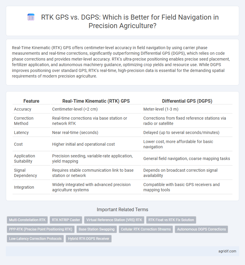
Real-Time Kinematic (RTK) GPS offers centimeter-level accuracy in field navigation by using carrier phase measurements and real-time corrections, significantly outperforming Differential GPS (DGPS), which relies on code phase corrections and provides meter-level accuracy. RTK's ultra-precise positioning enables precise seed placement, fertilizer application, and autonomous machinery guidance, optimizing crop yields and resource use. While DGPS improves positioning over standard GPS, RTK's real-time, high-precision data is essential for the demanding spatial requirements of modern precision agriculture.
Table of Comparison
| Feature | Real-Time Kinematic (RTK) GPS | Differential GPS (DGPS) |
|---|---|---|
| Accuracy | Centimeter-level (<2 cm) | Meter-level (1-3 m) |
| Correction Method | Real-time corrections via base station or network RTK | Corrections from fixed reference stations via radio or satellite |
| Latency | Near real-time (seconds) | Delayed (up to several seconds/minutes) |
| Cost | Higher initial and operational cost | Lower cost, more affordable for basic navigation |
| Application Suitability | Precision seeding, variable-rate application, yield mapping | General field navigation, coarse mapping tasks |
| Signal Dependency | Requires stable communication link to base station or network | Depends on broadcast correction signal availability |
| Integration | Widely integrated with advanced precision agriculture systems | Compatible with basic GPS receivers and mapping tools |
Introduction to Precision Agriculture and Field Navigation
Real-Time Kinematic (RTK) GPS offers centimeter-level accuracy by using carrier-phase measurements and corrections from a base station, enabling precise field navigation critical for precision agriculture. Differential GPS (DGPS) improves positioning accuracy to sub-meter levels by applying correction signals from network stations but lacks the centimeter precision necessary for tasks like automated planting. RTK's superior accuracy enhances crop management and resource efficiency, making it the preferred technology for real-time guidance in precision farming operations.
Understanding RTK GPS Technology
Real-Time Kinematic (RTK) GPS technology enhances positioning accuracy by using carrier-based ranging and correction signals from a base station, achieving centimeter-level precision essential for precision agriculture field navigation. Unlike Differential GPS (DGPS), which provides meter-level accuracy by correcting signal errors through reference stations, RTK GPS continuously processes phase measurements to deliver real-time positional data with minimal latency. This high-precision positioning enables farmers to optimize input applications, reduce overlap, and improve overall crop management efficiency.
Overview of Differential GPS (DGPS) Systems
Differential GPS (DGPS) enhances standard GPS accuracy by using ground-based reference stations to broadcast correction signals, reducing positional errors from several meters to approximately one meter. DGPS relies on fixed base stations that continuously monitor GPS signals and transmit differential corrections to nearby receivers, improving reliability for field navigation in precision agriculture. While not as precise as Real-Time Kinematic (RTK) GPS, DGPS systems provide a cost-effective solution for improving the accuracy of farm equipment guidance and crop management.
Accuracy Comparison: RTK GPS vs DGPS
Real-Time Kinematic (RTK) GPS offers centimeter-level accuracy in field navigation, typically achieving precision within 1-2 cm, compared to Differential GPS (DGPS), which provides accuracy around 1-3 meters. RTK GPS uses real-time corrections from base stations to the rover, enabling highly precise positioning essential for tasks like automated steering and variable rate application. DGPS relies on correction signals that improve standard GPS accuracy but cannot match the fine resolution and immediate correction capabilities of RTK systems in precision agriculture.
Signal Integrity and Reliability in Field Conditions
Real-Time Kinematic (RTK) GPS offers superior signal integrity and centimeter-level accuracy by utilizing carrier phase measurements and real-time corrections from base stations, ensuring reliable performance in challenging field conditions such as varying terrain and dense vegetation. Differential GPS (DGPS) improves positional accuracy by correcting satellite signals using reference stations but typically provides meter-level precision, which can be less reliable in obstructed environments due to signal latency and integrity issues. RTK's enhanced reliability and low latency corrections make it the preferred choice for precision agriculture applications requiring precise field navigation and consistent operational accuracy.
Cost Analysis: Investment and Operational Expenses
Real-Time Kinematic (RTK) GPS systems demand higher initial investment, typically ranging from $10,000 to $15,000 for equipment and setup, while Differential GPS (DGPS) setups cost approximately $2,000 to $5,000. Operational expenses for RTK include subscription fees for correction signals and maintenance of base stations, resulting in higher recurring costs compared to DGPS, which relies on less frequent updates and lower infrastructure requirements. Despite the elevated costs, RTK offers centimeter-level accuracy essential for precision agriculture, justifying the investment for high-value crops and large-scale farming operations.
Integration with Precision Agriculture Equipment
Real-Time Kinematic (RTK) GPS provides centimeter-level accuracy by correcting satellite signals in real time, making it ideal for precision agriculture equipment requiring precise field navigation. Differential GPS (DGPS) offers decimeter-level accuracy through correction signals but may lack the responsiveness needed for dynamic machinery operations. Integration of RTK GPS systems with tractors and drones enhances automated planting, fertilizing, and harvesting by enabling exact positioning and reducing overlap, thereby increasing efficiency and crop yield.
Data Correction Mechanisms: RTK vs DGPS
Real-Time Kinematic (RTK) GPS utilizes carrier phase measurements to provide centimeter-level positioning accuracy by correcting satellite signal errors in real-time through a base station and rover communication link. Differential GPS (DGPS) improves positioning by applying correction data from fixed ground-based reference stations, but its accuracy is typically limited to sub-meter levels due to reliance on code phase measurements. RTK's advanced data correction mechanism offers superior precision for field navigation in precision agriculture compared to the coarser correction approach used by DGPS.
Practical Applications in Crop Management
Real-Time Kinematic (RTK) GPS offers centimeter-level accuracy essential for precision agriculture tasks such as row crop planting, fertilizer application, and pesticide spraying, ensuring optimal input usage and minimizing crop damage. Differential GPS (DGPS), with meter-level accuracy, supports broader field operations like soil sampling and general field mapping but lacks the precision for high-accuracy tasks critical in modern crop management. Implementing RTK GPS enhances yield by enabling precise machinery guidance, reducing overlaps and gaps, whereas DGPS is cost-effective for less accuracy-sensitive activities.
Choosing the Right GPS Solution for Your Farm
Real-Time Kinematic (RTK) GPS provides centimeter-level accuracy crucial for precision agriculture tasks such as planting and spraying, while Differential GPS (DGPS) offers meter-level precision suitable for less demanding applications. Selecting the right GPS system depends on farm size, crop type, and budget, with RTK requiring a base station or subscription service to maintain high accuracy. Implementing RTK can significantly enhance operational efficiency and yield by enabling precise field navigation and input application.
Related Important Terms
Multi-Constellation RTK
Multi-Constellation Real-Time Kinematic (RTK) GPS significantly enhances field navigation accuracy in precision agriculture by integrating signals from multiple satellite systems such as GPS, GLONASS, Galileo, and BeiDou, achieving centimeter-level positioning with reduced signal latency and improved reliability compared to Differential GPS (DGPS). This multi-constellation RTK technology enables precise machine guidance and efficient input application, optimizing crop yields and minimizing resource waste in agricultural operations.
RTK NTRIP Caster
Real-Time Kinematic (RTK) GPS, enhanced by NTRIP caster technology, delivers centimeter-level accuracy by providing real-time correction data via internet protocol, significantly outperforming Differential GPS (DGPS) which offers meter-level precision using satellite-based correction signals. RTK NTRIP casters enable seamless data streaming to agricultural machinery, optimizing field navigation for tasks like planting and harvesting with unparalleled spatial accuracy and operational efficiency.
Virtual Reference Station (VRS) RTK
Virtual Reference Station (VRS) RTK GPS delivers centimeter-level positioning accuracy by creating a network of local reference stations that generate real-time correction data, significantly outperforming Differential GPS (DGPS) which offers meter-level accuracy through a single reference station. VRS RTK enhances field navigation precision in precision agriculture by minimizing signal latency and improving reliability, enabling optimal machinery guidance and resource application.
RTK Float vs RTK Fix Solution
Real-Time Kinematic (RTK) GPS provides centimeter-level accuracy by using carrier phase measurements, with RTK Fix offering a fixed integer solution for precise positioning, while RTK Float delivers a less accurate, ambiguity-resolved but not fixed solution during initial signal processing. Differential GPS (DGPS) improves accuracy by correcting satellite signals using reference station data but lacks the real-time centimeter precision of RTK, especially when comparing RTK Float's partial ambiguity resolution to RTK Fix's fully resolved position fixes crucial for precision agriculture field navigation.
PPP-RTK (Precise Point Positioning RTK)
PPP-RTK combines Precise Point Positioning and Real-Time Kinematic techniques to deliver centimeter-level accuracy in field navigation, outperforming traditional Differential GPS (DGPS) by eliminating the need for a base station and reducing latency. This advanced GNSS correction method enhances precision agriculture by providing real-time, highly accurate positioning crucial for automated machinery and precise crop management.
Base Station Swapping
Real-Time Kinematic (RTK) GPS offers centimeter-level accuracy through continuous correction from a fixed base station, making it superior to Differential GPS (DGPS) where accuracy relies on less frequent correction signals. Base station swapping in RTK enhances operational flexibility by allowing seamless transition between stations without compromising positioning precision in precision agriculture field navigation.
Cellular RTK Correction Streams
Cellular RTK correction streams provide centimeter-level accuracy by transmitting real-time satellite correction data via cellular networks, enhancing field navigation precision compared to Differential GPS (DGPS), which typically offers sub-meter accuracy through slower correction methods. Leveraging low-latency cellular connectivity, RTK GPS enables precise machinery guidance and variable-rate applications critical for optimizing crop management and resource use in precision agriculture.
Autonomous DGPS Corrections
Real-Time Kinematic (RTK) GPS offers centimeter-level accuracy by utilizing carrier phase measurements and real-time corrections, enabling precise field navigation essential for autonomous agricultural machinery. Autonomous DGPS corrections, while improving positional accuracy to a sub-meter level by using nearby reference stations, lack the ultra-precise correction capabilities of RTK, making RTK the preferred choice for precision tasks like planting and spraying in precision agriculture.
Low-Latency Correction Protocols
Real-Time Kinematic (RTK) GPS offers centimeter-level accuracy with low-latency correction protocols that provide instantaneous position updates, essential for precise field navigation in precision agriculture. Differential GPS (DGPS) delivers meter-level accuracy with higher latency in correction signals, making RTK the preferred choice for applications requiring rapid, real-time positional adjustments.
Hybrid RTK-DGPS Receiver
Hybrid RTK-DGPS receivers combine the centimeter-level accuracy of Real-Time Kinematic GPS with the signal correction robustness of Differential GPS, enhancing precision in field navigation for precision agriculture. This integration reduces positional errors and improves real-time data reliability, optimizing planting, fertilizing, and harvesting operations.
Real-Time Kinematic (RTK) GPS vs Differential GPS (DGPS) for field navigation Infographic