Real-Time Kinematic (RTK) GPS offers centimeter-level accuracy by using carrier phase measurements and real-time corrections, making it ideal for precision agriculture machinery navigation. Differential GPS (DGPS) improves standard GPS accuracy through correction signals but typically provides meter-level precision, which may not meet the stringent requirements for machine guidance on the field. For tasks demanding exact positioning such as autonomous planting and harvesting, RTK GPS significantly enhances operational efficiency and crop yield compared to DGPS.
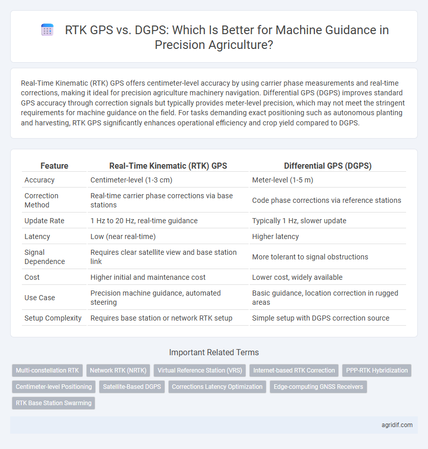
Table of Comparison
| Feature | Real-Time Kinematic (RTK) GPS | Differential GPS (DGPS) |
|---|---|---|
| Accuracy | Centimeter-level (1-3 cm) | Meter-level (1-5 m) |
| Correction Method | Real-time carrier phase corrections via base stations | Code phase corrections via reference stations |
| Update Rate | 1 Hz to 20 Hz, real-time guidance | Typically 1 Hz, slower update |
| Latency | Low (near real-time) | Higher latency |
| Signal Dependence | Requires clear satellite view and base station link | More tolerant to signal obstructions |
| Cost | Higher initial and maintenance cost | Lower cost, widely available |
| Use Case | Precision machine guidance, automated steering | Basic guidance, location correction in rugged areas |
| Setup Complexity | Requires base station or network RTK setup | Simple setup with DGPS correction source |
Introduction to Machine Guidance in Precision Agriculture
Real-Time Kinematic (RTK) GPS offers centimeter-level accuracy for machine guidance in precision agriculture, significantly enhancing field operations such as planting, fertilizer application, and harvesting. Differential GPS (DGPS) improves positioning accuracy by correcting satellite signal errors through ground-based reference stations but typically provides meter-level precision. The higher accuracy and real-time corrections of RTK GPS make it the preferred technology for precise tractor and equipment navigation, optimizing resource use and crop yields.
Overview of RTK GPS Technology
Real-Time Kinematic (RTK) GPS employs carrier-phase measurements to deliver centimeter-level positioning accuracy, essential for precision agriculture machine guidance. Unlike Differential GPS (DGPS), which relies on code-phase corrections and achieves meter-level accuracy, RTK enhances spatial precision by processing real-time corrections from base stations. This high-accuracy positioning enables automated steering systems to optimize field operations, improve input efficiency, and reduce crop damage.
Overview of Differential GPS (DGPS) Technology
Differential GPS (DGPS) enhances standard GPS accuracy by using a network of fixed ground-based reference stations to broadcast correction signals, reducing positional errors to within 1 to 3 meters. In precision agriculture, DGPS improves machine guidance by providing reliable, real-time location adjustments that aid in field mapping, planting, and harvesting operations. This technology is widely adopted for its cost-effectiveness and ability to deliver greater accuracy compared to standalone GPS, though it generally does not match the centimeter-level precision offered by Real-Time Kinematic (RTK) GPS systems.
Accuracy Comparison: RTK GPS vs DGPS
Real-Time Kinematic (RTK) GPS delivers centimeter-level accuracy by utilizing carrier phase measurements and real-time correction data from a base station, surpassing the meter-level precision typically offered by Differential GPS (DGPS), which relies on pseudorange corrections. RTK GPS's superior positional accuracy significantly enhances machine guidance in precision agriculture, enabling precise seed placement, fertilization, and crop monitoring. This heightened accuracy reduces overlap and input waste, improving overall field efficiency and crop yield.
Signal Correction Methods: RTK vs DGPS
Real-Time Kinematic (RTK) GPS provides centimeter-level accuracy by using carrier phase measurements and corrections from a base station in real time, enabling precise machine guidance for tasks like planting and harvesting. Differential GPS (DGPS) improves positioning accuracy to within a meter by applying correction signals from a network of fixed ground reference stations, but lacks the precision needed for fine-scale agricultural operations. RTK's advanced signal correction method offers superior spatial accuracy essential for optimizing field operations and reducing overlap in precision agriculture.
Implementation Costs and Infrastructure Requirements
Real-Time Kinematic (RTK) GPS systems demand higher initial investment due to the need for base stations or subscription services but deliver centimeter-level accuracy crucial for precision agriculture machinery guidance. Differential GPS (DGPS) offers a more affordable setup with lower infrastructure requirements by relying on ground reference stations, though its accuracy is limited to meter-level precision. Farmers must weigh RTK's higher cost and complex infrastructure against DGPS's affordability and reduced precision when selecting a guidance system for efficient machine operation.
Reliability and Availability in Field Conditions
Real-Time Kinematic (RTK) GPS offers centimeter-level accuracy and high reliability for machine guidance in precision agriculture, ensuring consistent performance even in challenging field conditions such as dense foliage or uneven terrain. Differential GPS (DGPS), while providing improved accuracy over standard GPS, typically achieves meter-level precision and may experience reduced availability and reliability under obstructed environments. RTK's enhanced satellite correction techniques and real-time data integration result in superior machine guidance reliability and continuous operational availability critical for time-sensitive agricultural tasks.
Integration with Precision Agriculture Equipment
Real-Time Kinematic (RTK) GPS offers centimeter-level accuracy crucial for precision agriculture equipment, enabling precise machine guidance and optimized field operations. Compared to Differential GPS (DGPS), RTK provides superior position correction through fixed base stations and real-time corrections, ensuring minimal latency in autonomous tractor navigation. Integration of RTK with variable rate technology and automated steering systems enhances efficiency in planting, fertilizing, and harvesting by improving spatial data reliability and operational precision.
Use Cases: RTK GPS vs DGPS in Crop Management
RTK GPS offers centimeter-level accuracy, crucial for precision tasks like seed planting and fertilizer application, enhancing crop yield and resource efficiency. DGPS provides meter-level accuracy suitable for broader field mapping and monitoring soil conditions, supporting effective crop health assessment. Integrating RTK GPS in crop management ensures precise machine guidance for variable rate applications, while DGPS remains valuable for cost-effective, large-scale spatial data collection.
Future Trends in GPS-Based Machine Guidance Systems
Future trends in GPS-based machine guidance systems emphasize enhanced accuracy and reliability, with Real-Time Kinematic (RTK) GPS expected to dominate due to its centimeter-level precision and rapid correction updates. Advances in multi-constellation GNSS integration and Machine Learning algorithms will further improve the robustness and fault tolerance of RTK systems compared to Differential GPS (DGPS), which offers meter-level accuracy but slower update rates. The ongoing development of cloud-based correction services and 5G connectivity will enable seamless data transmission and real-time decision-making, accelerating the adoption of fully autonomous machinery in precision agriculture.
Related Important Terms
Multi-constellation RTK
Multi-constellation Real-Time Kinematic (RTK) GPS enhances machine guidance accuracy by leveraging signals from multiple satellite systems such as GPS, GLONASS, Galileo, and BeiDou, delivering centimeter-level precision critical for precision agriculture applications. Compared to Differential GPS (DGPS), multi-constellation RTK offers faster convergence times, improved reliability in obstructed environments, and superior positional accuracy, enabling efficient field operations and optimized input usage.
Network RTK (NRTK)
Network Real-Time Kinematic (NRTK) GPS provides centimeter-level positioning accuracy by utilizing a network of base stations to deliver real-time correction data, significantly enhancing machine guidance precision compared to traditional Differential GPS (DGPS). NRTK minimizes errors caused by atmospheric interference and satellite orbit inaccuracies, enabling more efficient and reliable operations in precision agriculture machinery control.
Virtual Reference Station (VRS)
Real-Time Kinematic (RTK) GPS using Virtual Reference Station (VRS) technology provides centimeter-level accuracy by generating correction data from a network of fixed base stations, improving machine guidance precision over traditional Differential GPS (DGPS), which offers meter-level accuracy through single base station corrections. VRS enhances operational efficiency in precision agriculture by reducing signal latency and increasing positional reliability across large farming areas compared to DGPS.
Internet-based RTK Correction
Internet-based RTK correction enhances Real-Time Kinematic GPS by providing centimeter-level accuracy and faster signal correction compared to Differential GPS, which relies on ground-based reference stations with lower precision. This advanced connectivity reduces latency and extends coverage, making RTK GPS more effective for precision agriculture machine guidance and automated operations.
PPP-RTK Hybridization
PPP-RTK hybridization enhances machine guidance by combining the centimeter-level accuracy of Real-Time Kinematic (RTK) GPS with the wide-area correction capability of Differential GPS (DGPS), ensuring reliable positioning across diverse agricultural environments. This hybrid approach improves precision in planting, spraying, and harvesting operations, reducing input costs and increasing crop yields through superior spatial accuracy and real-time correction updates.
Centimeter-level Positioning
Real-Time Kinematic (RTK) GPS provides centimeter-level positioning accuracy by utilizing carrier-phase measurements and real-time correction data from a base station, crucial for precision agriculture machinery guidance. Differential GPS (DGPS) offers meter-level accuracy through satellite signal corrections but lacks the fine precision and rapid update rates necessary for optimal machine control in high-precision farming applications.
Satellite-Based DGPS
Satellite-Based Differential GPS (DGPS) enhances positional accuracy by correcting GPS signals using reference stations, achieving precision within 1 to 3 meters, which is suitable for basic machine guidance in precision agriculture. Real-Time Kinematic (RTK) GPS offers centimeter-level accuracy by processing carrier-phase measurements in real time, enabling more precise control for planting, spraying, and harvesting operations.
Corrections Latency Optimization
Real-Time Kinematic (RTK) GPS offers centimeter-level accuracy with latency under one second by using carrier-phase measurements and immediate correction signals from a base station, outperforming Differential GPS (DGPS) which typically provides meter-level accuracy with higher latency due to reliance on code-phase corrections and delayed correction broadcasts. Optimizing corrections latency in RTK involves minimizing data transmission delays and enhancing base station communication protocols, crucial for precise machine guidance in precision agriculture applications.
Edge-computing GNSS Receivers
Real-Time Kinematic (RTK) GPS offers centimeter-level accuracy by processing satellite data and corrections at the edge, enabling precise machine guidance in precision agriculture, whereas Differential GPS (DGPS) typically provides meter-level accuracy with corrections sent from centralized base stations. Edge-computing GNSS receivers in RTK systems reduce latency and dependence on external networks, enhancing real-time decision-making and operational efficiency for autonomous farming equipment.
RTK Base Station Swarming
RTK base station swarming enhances machine guidance accuracy in precision agriculture by combining multiple RTK GPS base stations to deliver centimeter-level positioning, outperforming traditional DGPS systems that provide meter-level accuracy. This networked approach improves reliability and continuity of signals across large fields, enabling precise control of agricultural machinery for optimized planting, fertilization, and harvesting.
Real-Time Kinematic (RTK) GPS vs Differential GPS (DGPS) for Machine Guidance Infographic