Remote sensing utilizes satellite or drone imagery to monitor crop health over large areas, providing comprehensive data on vegetation indices and stress detection. Proximal sensing involves ground-based sensors positioned close to the plants for detailed measurements of soil moisture, nutrient levels, and plant physiology. Combining both methods enhances precision agriculture by delivering macro and micro-level insights for optimized crop management.
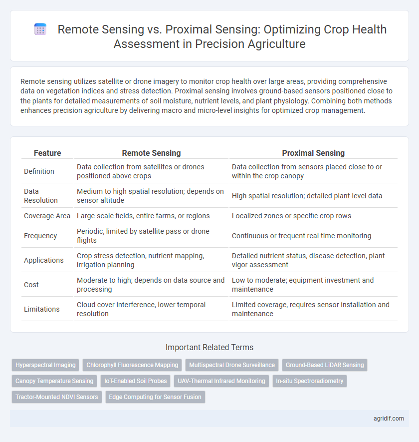
Table of Comparison
| Feature | Remote Sensing | Proximal Sensing |
|---|---|---|
| Definition | Data collection from satellites or drones positioned above crops | Data collection from sensors placed close to or within the crop canopy |
| Data Resolution | Medium to high spatial resolution; depends on sensor altitude | High spatial resolution; detailed plant-level data |
| Coverage Area | Large-scale fields, entire farms, or regions | Localized zones or specific crop rows |
| Frequency | Periodic, limited by satellite pass or drone flights | Continuous or frequent real-time monitoring |
| Applications | Crop stress detection, nutrient mapping, irrigation planning | Detailed nutrient status, disease detection, plant vigor assessment |
| Cost | Moderate to high; depends on data source and processing | Low to moderate; equipment investment and maintenance |
| Limitations | Cloud cover interference, lower temporal resolution | Limited coverage, requires sensor installation and maintenance |
Introduction to Crop Health Assessment in Precision Agriculture
Remote sensing employs satellite or drone imagery to capture large-scale crop health data through spectral analysis, enabling monitoring of vegetation indices like NDVI for timely stress detection. Proximal sensing involves ground-based sensors positioned near plants to provide high-resolution, real-time measurements of parameters such as chlorophyll content and soil moisture. Integrating remote and proximal sensing technologies enhances accuracy in crop health assessment by combining broad spatial coverage with detailed onsite data, optimizing precision agriculture practices.
Fundamentals of Remote Sensing Technologies
Remote sensing technologies utilize satellite or drone-mounted sensors to capture multispectral and hyperspectral images, providing detailed crop health data over large areas. These systems detect electromagnetic radiation reflected from crops, enabling early identification of stress, nutrient deficiencies, and disease. Fundamental technologies include optical sensors, thermal sensors, and LiDAR, which collectively enhance precision agriculture by delivering accurate, timely information for optimized crop management.
Understanding Proximal Sensing Methods
Proximal sensing methods in precision agriculture utilize sensors positioned close to crops, such as handheld devices, drones, or tractor-mounted equipment, to capture detailed data on plant health indicators like chlorophyll levels, canopy temperature, and soil moisture. These methods provide high-resolution, real-time information essential for detecting early stress signals and enabling precise, site-specific management practices. Compared to remote sensing, proximal sensing offers improved accuracy and immediacy for monitoring nutrient deficiencies, pest infestations, and water stress within individual fields.
Key Differences: Remote Sensing vs Proximal Sensing
Remote sensing utilizes satellite or drone-mounted sensors to capture crop health data over large areas, offering broad spatial coverage and temporal frequency. Proximal sensing involves ground-based, close-range devices like handheld sensors or tractor-mounted equipment, providing high-resolution, detailed information at specific points within the field. The key differences lie in scale, resolution, and data granularity, with remote sensing suited for extensive monitoring and proximal sensing optimized for precise, localized crop health assessment.
Data Acquisition and Resolution Comparison
Remote sensing in precision agriculture uses satellite or drone imagery to capture large-scale crop health data with moderate spatial resolution, enabling broad area monitoring. Proximal sensing relies on ground-based sensors such as handheld devices or tractor-mounted equipment, providing high-resolution, detailed information at the plant or row level. Data acquisition frequency is higher with proximal sensing due to its close range, while remote sensing offers wider coverage but may be limited by weather conditions and revisit times.
Accuracy and Reliability of Crop Health Indicators
Remote sensing uses satellite or drone imagery to capture large-scale crop health indicators like vegetation indices, offering broad spatial coverage but sometimes limited accuracy due to atmospheric interference and lower resolution. Proximal sensing involves ground-based sensors measuring parameters such as chlorophyll content and leaf moisture directly, resulting in higher precision and reliability in crop health assessment. Combining both methods enhances data accuracy and enables more robust decision-making for precision agriculture management.
Cost and Scalability in Field Applications
Remote sensing offers broad scalability ideal for large-scale crop health assessment but often entails higher initial costs due to satellite or drone technology investments. Proximal sensing provides cost-effective, high-resolution data tailored for smaller fields but requires more labor-intensive deployment, limiting scalability. Combining both methods can optimize cost efficiency and spatial coverage for comprehensive agricultural monitoring.
Integration with Decision Support Systems
Remote sensing utilizes satellite and drone imagery to provide large-scale, multispectral data for crop health assessment, enabling timely detection of stress patterns that integrate seamlessly with decision support systems (DSS) for precise interventions. Proximal sensing, involving ground-based sensors such as soil probes and canopy analyzers, offers high-resolution, localized data that enhances DSS accuracy by complementing remote sensing insights with real-time, site-specific measurements. The integration of both sensing methods within DSS frameworks optimizes crop management decisions, improving yield forecasts and resource allocation efficiency.
Challenges and Limitations of Each Approach
Remote sensing offers extensive spatial coverage for crop health assessment but faces challenges with cloud interference and lower resolution in dense canopies. Proximal sensing provides higher accuracy and real-time data but is limited by spatial extent and labor-intensive implementation. Both methods require calibration and integration with crop models to address variability and enhance precision agriculture outcomes.
Future Trends in Sensing Technologies for Crop Monitoring
Remote sensing technologies, including satellite and drone imagery, are advancing with higher resolution sensors and real-time data analytics, enabling more precise crop health monitoring over large areas. Proximal sensing devices, such as soil and plant sensors, are becoming increasingly integrated with IoT platforms to provide continuous, localized data on crop conditions and nutrient status. Emerging trends emphasize the fusion of remote and proximal sensing data using AI algorithms to enhance predictive accuracy and decision support in precision agriculture.
Related Important Terms
Hyperspectral Imaging
Hyperspectral imaging in remote sensing offers extensive spectral data enabling precise identification of crop stress and nutrient deficiencies over large agricultural areas. Proximal sensing, while limited in coverage, provides higher spatial resolution and real-time hyperspectral data crucial for detailed crop health monitoring at the plant level.
Chlorophyll Fluorescence Mapping
Remote sensing utilizes satellite or drone-based sensors to capture chlorophyll fluorescence signals across extensive crop fields, enabling large-scale and real-time monitoring of photosynthetic efficiency and plant stress. Proximal sensing involves ground-based instruments positioned close to plants, providing high-resolution, precise chlorophyll fluorescence mapping that detects subtle variations in crop health at the leaf or canopy level.
Multispectral Drone Surveillance
Multispectral drone surveillance in precision agriculture offers high-resolution remote sensing capabilities that enable detailed crop health assessment by capturing data across multiple spectral bands, enhancing the detection of stress factors such as nutrient deficiencies and pest infestations. Proximal sensing, while effective for localized measurements, lacks the expansive coverage and spatial detail provided by drone-mounted multispectral sensors, making remote sensing the preferred method for comprehensive crop monitoring and management.
Ground-Based LiDAR Sensing
Ground-based LiDAR sensing in precision agriculture offers high-resolution, three-dimensional data for crop health assessment, enabling detailed monitoring of plant structure and biomass. This proximal sensing technique provides more accurate and timely information compared to remote sensing by reducing atmospheric interference and capturing fine-scale variability within fields.
Canopy Temperature Sensing
Remote sensing utilizes satellite or drone-based thermal imaging to monitor canopy temperature over large agricultural fields, enabling early detection of crop stress and water deficiency. Proximal sensing employs handheld or tractor-mounted infrared sensors for high-resolution, field-level temperature data, offering precise and immediate assessment of plant health conditions.
IoT-Enabled Soil Probes
IoT-enabled soil probes in proximal sensing provide real-time, high-resolution data on soil moisture, nutrient levels, and temperature directly from the root zone, enabling precise crop health assessments and efficient resource management. Unlike remote sensing, which offers broader aerial or satellite imagery, proximal sensing with IoT soil probes delivers actionable insights at the micro-environmental scale critical for targeted irrigation and fertilization in precision agriculture.
UAV-Thermal Infrared Monitoring
UAV-Thermal Infrared Monitoring in precision agriculture leverages remote sensing to capture high-resolution temperature variations across crop canopies, enabling early detection of plant stress, water deficit, and disease outbreaks from an aerial perspective. Compared to proximal sensing, which involves ground-based measurements with limited spatial coverage, UAV thermal imaging provides comprehensive, rapid, and non-invasive crop health assessment, improving irrigation management and yield prediction accuracy.
In-situ Spectroradiometry
In-situ spectroradiometry, a key proximal sensing technique, provides highly accurate, leaf-level spectral data essential for precise crop health assessment, enabling detection of stress factors such as nutrient deficiency and disease at an early stage. Compared to remote sensing, in-situ spectroradiometry offers superior spatial resolution and calibration capabilities, making it invaluable for ground-truthing satellite or drone imagery in precision agriculture.
Tractor-Mounted NDVI Sensors
Tractor-mounted NDVI sensors provide high-resolution proximal sensing data, enabling precise crop health assessment by capturing real-time spectral reflectance directly from the canopy at close range. Unlike remote sensing from satellites or drones, these sensors offer greater accuracy and spatial specificity, essential for targeted interventions in precision agriculture.
Edge Computing for Sensor Fusion
Remote sensing integrates satellite and drone imagery with edge computing to deliver real-time crop health data, enabling precise and timely decision-making. Proximal sensing combines ground-based sensors and edge devices for localized, high-resolution monitoring, enhancing sensor fusion accuracy and reducing data transmission latency in precision agriculture.
Remote Sensing vs Proximal Sensing for crop health assessment Infographic