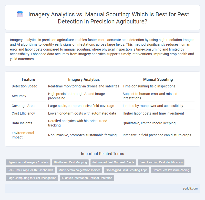
Imagery analytics in precision agriculture enables faster, more accurate pest detection by using high-resolution images and AI algorithms to identify early signs of infestations across large fields. This method significantly reduces human error and labor costs compared to manual scouting, where physical inspection is time-consuming and limited by accessibility. Enhanced data accuracy from imagery analytics supports timely interventions, improving crop health and yield outcomes.
Table of Comparison
| Feature | Imagery Analytics | Manual Scouting |
|---|---|---|
| Detection Speed | Real-time monitoring via drones and satellites | Time-consuming field inspections |
| Accuracy | High precision through AI and image processing | Subject to human error and missed infestations |
| Coverage Area | Large-scale, comprehensive field coverage | Limited by manpower and accessibility |
| Cost Efficiency | Lower long-term costs with automated data | Higher labor costs and time investment |
| Data Insights | Detailed analytics with historical trend tracking | Qualitative, limited record-keeping |
| Environmental Impact | Non-invasive, promotes sustainable farming | Intensive in-field presence can disturb crops |
Precision Agriculture: Redefining Pest Detection
Imagery analytics leverages high-resolution drone and satellite images combined with AI algorithms to detect pest infestations with greater accuracy and speed than manual scouting methods. This technology enables real-time monitoring of crop health, identifying pest hotspots and stress indicators that might be missed by human scouts. Precision agriculture's integration of imagery analytics significantly reduces crop damage and optimizes pesticide application, enhancing yield and sustainability.
Imagery Analytics: Harnessing Technology for Pest Identification
Imagery analytics leverages high-resolution satellite and drone imagery combined with advanced machine learning algorithms to detect pest infestations in crops with greater accuracy and speed than manual scouting. This technology enables real-time monitoring of vast agricultural fields, identifying subtle changes in plant health and enabling precise, targeted pest management. Enhanced data-driven insights reduce crop damage and optimize pesticide application, promoting sustainable farming practices.
Manual Scouting: Traditional Methods and Their Role
Manual scouting in pest detection relies on hands-on field inspections by trained agronomists or farmers, using visual assessment and simple tools like hand lenses. These traditional methods provide real-time, localized insights into pest presence and crop health, enabling targeted intervention. Despite being labor-intensive and time-consuming, manual scouting remains essential for verifying and complementing data from emerging technologies like imagery analytics.
Accuracy Comparison: Imagery Analytics vs Manual Scouting
Imagery analytics in precision agriculture offers higher accuracy in pest detection by utilizing high-resolution satellite and drone images combined with AI algorithms that identify pest infestations earlier than manual scouting. Manual scouting relies heavily on human observation, which can miss early or hidden pest activity and is subject to variability based on scout expertise and coverage limitations. Studies show imagery analytics improves detection rates by up to 30%, enabling more precise intervention and reducing crop losses.
Time Efficiency: Automated Imagery vs Field Labor
Automated imagery analytics in precision agriculture dramatically reduces the time required for pest detection by capturing and processing high-resolution images across large fields within hours, compared to manual scouting that can take days and demands significant labor resources. High-throughput drones and satellite imagery deliver near-real-time pest mapping, enabling quicker intervention and minimizing crop damage. This time efficiency translates into cost savings and improved yield management, making imagery analytics a superior alternative to traditional field labor methods.
Cost Considerations in Pest Detection Methods
Imagery analytics for pest detection significantly reduces labor costs compared to manual scouting by automating data collection with drones and satellite imaging, enabling real-time monitoring over large crop areas. While initial investment in advanced sensors and software can be high, the scalability and frequency of data acquisition lower long-term operational expenses. Manual scouting involves recurrent labor costs, limited field coverage, and slower response times, making it less cost-effective for large-scale precision agriculture operations focused on early pest detection.
Data Volume and Insights: Satellite, Drone, and Manual Approaches
Satellite and drone imagery analytics enable processing of vast data volumes, capturing high-resolution multispectral images for precise pest detection over extensive farmland areas. These technologies provide continuous monitoring and detailed, quantifiable insights on pest infestation patterns, facilitating timely intervention and resource optimization. Manual scouting, limited by human capacity and time, offers localized, qualitative observations but struggles to scale, making it less efficient for large-scale pest management compared to automated imagery analytics.
Scalability: Large-Scale Monitoring with Imagery Analytics
Imagery analytics enables scalable pest detection across extensive agricultural fields by leveraging high-resolution satellite and drone imagery, allowing real-time monitoring and rapid identification of pest outbreaks. Unlike manual scouting, which is labor-intensive and time-consuming, imagery analytics processes vast data sets efficiently, providing comprehensive coverage that enhances early intervention strategies. This technology supports precise pest management decisions, reducing crop loss and optimizing resource allocation on a large scale.
Integrating Imagery Analytics with Manual Ground Truthing
Integrating imagery analytics with manual ground truthing enhances pest detection accuracy by combining high-resolution drone or satellite imagery with on-the-ground verification of pest presence and damage. This hybrid approach leverages real-time data to identify pest infestation patterns, enabling targeted interventions that reduce crop loss and optimize pesticide application. Utilizing multispectral and thermal imagery alongside manual scouting supports precise decision-making and sustainable pest management in precision agriculture.
Future Trends: Advancements in Pest Detection Technologies
Imagery analytics leverages high-resolution satellite, drone, and multispectral imaging to provide real-time, precise pest detection across vast agricultural fields, surpassing the spatial limitations of manual scouting. Advances in machine learning algorithms and AI-driven image processing enhance early pest identification, enabling targeted interventions that reduce chemical usage and crop damage. Future trends indicate integration of hyperspectral sensors and edge computing will further improve accuracy and timeliness, transforming pest management efficiency in precision agriculture.
Related Important Terms
Hyperspectral Imagery Analysis
Hyperspectral imagery analysis utilizes advanced sensors to capture detailed spectral data across hundreds of bands, enabling precise identification of pest infestations at early stages compared to manual scouting methods. This technology enhances pest detection accuracy and efficiency by analyzing subtle plant stress signals unobservable to the human eye, facilitating timely intervention in precision agriculture.
UAV-based Pest Mapping
UAV-based pest mapping leverages high-resolution imagery analytics to detect early signs of pest infestation with greater accuracy and efficiency compared to manual scouting. Advanced spectral imaging and AI-powered analysis enable timely intervention, reducing crop damage and optimizing pest management strategies in precision agriculture.
Automated Pest Outbreak Alerts
Imagery analytics leverages satellite and drone-captured data combined with machine learning algorithms to provide real-time, automated pest outbreak alerts, significantly reducing the delay and human error associated with manual scouting. This technology enhances early pest detection accuracy, enabling precise and timely intervention that optimizes crop health and minimizes yield loss.
Deep Learning Pest Identification
Deep learning pest identification leverages high-resolution imagery analytics to accurately detect and classify pest infestations at early stages, surpassing the speed and precision of manual scouting methods. Integrating convolutional neural networks with multispectral drone imagery enhances pest monitoring by enabling real-time, scalable analysis across extensive agricultural fields, reducing crop damage and optimizing pest management strategies.
Real-Time Crop Health Dashboards
Imagery analytics leverage multispectral and hyperspectral data to deliver real-time crop health dashboards, enabling immediate detection of pest infestations with higher accuracy and spatial resolution than manual scouting. These real-time insights facilitate targeted interventions, reducing crop damage and optimizing pesticide use for sustainable pest management.
Multispectral Vegetation Indices
Imagery analytics utilizing multispectral vegetation indices like NDVI and GNDVI enhances pest detection accuracy by capturing subtle stress patterns invisible to the naked eye during manual scouting. These indices provide consistent, large-scale spatial data enabling early identification and precise intervention, thereby improving crop health management in precision agriculture.
Geo-tagged Field Scouting Apps
Geo-tagged field scouting apps enhance pest detection accuracy by enabling precise location tracking and real-time data collection, streamlining manual scouting processes. Imagery analytics leverages high-resolution satellite or drone images to identify pest hotspots at scale, offering rapid and comprehensive monitoring compared to traditional ground-based scouting.
Smart Pest Pressure Zoning
Imagery analytics leverages high-resolution drone and satellite images to create precise smart pest pressure zones, enabling real-time monitoring and targeted interventions that significantly outperform the time-consuming and less accurate manual scouting methods. This technology enhances pest management by integrating spatial data and machine learning algorithms, reducing crop losses and optimizing pesticide usage for sustainable agriculture.
Edge Computing for Pest Recognition
Edge computing enhances pest detection in precision agriculture by processing imagery analytics directly on-site, reducing latency and increasing real-time responsiveness compared to manual scouting. This approach enables immediate identification and classification of pests using advanced algorithms, improving crop health monitoring and minimizing reliance on time-consuming, labor-intensive field inspections.
AI-driven Infestation Hotspot Detection
AI-driven imagery analytics enables rapid and accurate identification of pest infestation hotspots by processing high-resolution aerial images with advanced machine learning algorithms, significantly outperforming manual scouting in both scale and precision. This technology leverages real-time data and spatial patterns to detect early signs of infestation, minimizing crop damage and optimizing targeted intervention strategies.
Imagery Analytics vs Manual Scouting for Pest Detection Infographic