Yield mapping captures spatial variations in crop output through harvest data, providing direct insights into productivity differences across the field. Soil mapping analyzes physical and chemical properties of soil, offering foundational information on nutrient levels, texture, and moisture that influence plant growth. Combining yield mapping with soil mapping enhances precision agriculture by enabling targeted interventions based on both productivity outcomes and soil conditions.
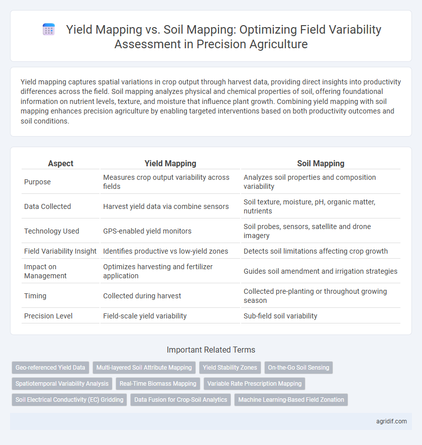
Table of Comparison
| Aspect | Yield Mapping | Soil Mapping |
|---|---|---|
| Purpose | Measures crop output variability across fields | Analyzes soil properties and composition variability |
| Data Collected | Harvest yield data via combine sensors | Soil texture, moisture, pH, organic matter, nutrients |
| Technology Used | GPS-enabled yield monitors | Soil probes, sensors, satellite and drone imagery |
| Field Variability Insight | Identifies productive vs low-yield zones | Detects soil limitations affecting crop growth |
| Impact on Management | Optimizes harvesting and fertilizer application | Guides soil amendment and irrigation strategies |
| Timing | Collected during harvest | Collected pre-planting or throughout growing season |
| Precision Level | Field-scale yield variability | Sub-field soil variability |
Introduction to Field Variability Assessment
Yield mapping utilizes real-time data collected during harvest to identify spatial variations in crop productivity, offering precise insights into how different areas of a field perform. Soil mapping involves analyzing soil properties such as texture, moisture, nutrient levels, and organic matter to understand the underlying causes of variability within the field. Combining yield and soil mapping enhances field variability assessment by providing a comprehensive understanding of both crop performance and soil conditions, enabling targeted management practices to optimize productivity.
Understanding Yield Mapping in Precision Agriculture
Yield mapping in precision agriculture involves collecting spatial data on crop production using GPS-equipped harvesters, enabling farmers to analyze field variability at a detailed level. This data-driven approach helps identify high and low productivity zones, facilitating targeted interventions such as variable-rate fertilization and irrigation. Understanding yield mapping's role enhances decision-making accuracy, ultimately improving crop management and maximizing agricultural efficiency.
Fundamentals of Soil Mapping Techniques
Soil mapping techniques in precision agriculture involve detailed analysis of soil properties such as texture, nutrient content, moisture levels, and pH variability using tools like electromagnetic sensors, remote sensing, and GPS-guided soil sampling. These fundamentals enable accurate delineation of management zones by capturing spatial heterogeneity within fields, facilitating targeted interventions to optimize input use and improve crop performance. Unlike yield mapping, which records crop output data post-harvest, soil mapping provides proactive insights into underlying soil conditions essential for adaptive field management and sustainable productivity.
Key Differences Between Yield Mapping and Soil Mapping
Yield mapping captures spatial variability by recording crop productivity data during harvest using GPS-enabled combines, providing real-time insights into field performance. Soil mapping involves collecting and analyzing soil samples across the field to determine soil properties such as nutrient levels, texture, and moisture retention, which influence crop growth potential. The key difference lies in yield mapping reflecting actual crop output patterns, while soil mapping identifies underlying soil conditions causing variability, enabling targeted management practices.
Data Collection Methods: Yield vs. Soil Mapping
Yield mapping utilizes GPS-equipped combine harvesters to collect spatial data on crop output in real-time, providing high-resolution information on productivity variability across the field. Soil mapping relies on sensors, soil sampling, and proximal or remote sensing technologies to assess soil properties such as texture, moisture, nutrient levels, and organic matter content at various depths and scales. Data collection for yield mapping is typically temporal and crop-specific, while soil mapping offers more static but comprehensive insights into the underlying factors driving variability.
Accuracy and Reliability: Comparing Mapping Technologies
Yield mapping utilizes real-time crop performance data captured by harvesters equipped with GPS and sensors, providing highly accurate and reliable spatial variability information on actual crop output. Soil mapping employs geospatial technology combined with soil sampling and sensor data to deliver detailed insights into soil properties such as texture, nutrient levels, and moisture content, which are crucial for understanding field variability. When comparing accuracy and reliability, yield mapping offers direct measurement of crop response variability, while soil mapping provides foundational data that supports predictive modeling, making their integration essential for comprehensive field management in precision agriculture.
Spatial Resolution: How Yield and Soil Maps Differ
Yield mapping uses spatial data collected at harvest with precision GPS units, typically offering fine-scale resolution down to individual rows or small plot areas, enabling detailed variability assessment of crop performance within fields. Soil mapping relies on data from soil sampling and sensors, often aggregated over larger grid cells or management zones, resulting in coarser spatial resolution that captures broader edaphic property patterns rather than hyper-local variability. The higher spatial resolution of yield maps facilitates precise management decisions by highlighting real-time crop response, while soil maps provide foundational information about soil heterogeneity essential for long-term field management planning.
Benefits and Limitations of Yield Mapping
Yield mapping provides spatially detailed data on crop performance, enabling farmers to identify high and low productivity zones for targeted management. Its benefits include real-time assessment of crop variability and direct measurement of harvest output, which improves decision-making for input application. Limitations involve dependency on accurate yield monitors and the inability to capture underlying soil properties, requiring complementary soil mapping for comprehensive field variability assessment.
Advantages and Challenges of Soil Mapping
Soil mapping offers detailed insights into soil properties such as texture, moisture, nutrient content, and pH levels, enabling precise management of field variability for optimized crop growth. The advantages include improved input efficiency, targeted interventions, and enhanced sustainability through site-specific nutrient management and irrigation. Challenges involve the high cost of data collection, the complexity of interpreting diverse soil data, and the need for advanced technology and expertise to create accurate, actionable maps.
Integrating Yield and Soil Maps for Enhanced Decision-Making
Integrating yield mapping and soil mapping offers a comprehensive approach to field variability assessment, enabling precise identification of spatial patterns affecting crop performance. Yield maps provide real-time data on crop productivity, while soil maps reveal underlying soil properties such as texture, nutrient content, and moisture levels. Combining these datasets enhances decision-making by optimizing resource allocation, improving fertilizer application, and increasing overall farm efficiency in precision agriculture.
Related Important Terms
Geo-referenced Yield Data
Geo-referenced yield data collected through yield mapping provides precise spatial variability insights based on actual crop performance, enabling targeted management decisions for optimizing productivity. Soil mapping offers foundational information on soil properties, but integrating geo-referenced yield maps enhances field variability assessment by directly reflecting the crop response to soil and environmental conditions.
Multi-layered Soil Attribute Mapping
Multi-layered soil attribute mapping enhances field variability assessment by providing detailed spatial data on soil texture, moisture, nutrient levels, and organic matter across different depths, enabling more precise yield predictions and crop management decisions. Yield mapping captures crop performance variability but lacks the underlying soil property insights that multi-layered soil maps deliver, making the latter essential for targeted interventions in precision agriculture.
Yield Stability Zones
Yield mapping provides real-time data on crop performance across different field zones, enabling the identification of Yield Stability Zones where productivity remains consistent over time. Soil mapping offers detailed information on soil properties influencing crop growth, but yield mapping more effectively captures spatial variability critical for managing and optimizing Yield Stability Zones in precision agriculture.
On-the-Go Soil Sensing
On-the-go soil sensing integrates real-time data collection into yield mapping, allowing for precise assessment of field variability by capturing soil nutrient levels, moisture content, and texture differences dynamically. This method enhances spatial resolution beyond traditional static soil mapping, enabling adaptive management decisions that optimize crop yield and resource use efficiency.
Spatiotemporal Variability Analysis
Yield mapping captures crop performance variability through GPS-referenced harvest data, offering real-time insights into spatial yield differences. Soil mapping analyzes soil properties like texture, moisture, and nutrient levels, providing foundational spatiotemporal variability data to optimize site-specific management in precision agriculture.
Real-Time Biomass Mapping
Yield mapping provides spatial data on crop output variability, while soil mapping offers insights into nutrient and moisture levels affecting growth; real-time biomass mapping enhances precision agriculture by integrating live crop condition metrics with these datasets, enabling dynamic field variability assessment and optimized input application.
Variable Rate Prescription Mapping
Yield mapping captures spatial crop output variability through GPS and harvested yield data, enabling precise Variable Rate Prescription (VRP) adjustments for fertilizers and inputs. Soil mapping assesses nutrient levels, texture, and moisture, providing foundational data that enhances VRP accuracy by tailoring input applications to specific soil conditions.
Soil Electrical Conductivity (EC) Gridding
Yield mapping provides spatial crop performance data, while soil mapping using Soil Electrical Conductivity (EC) gridding offers detailed insights into soil texture, moisture, and salinity variability critical for field management decisions. EC gridding enhances precision agriculture by enabling targeted interventions based on soil condition variability, improving crop yield and resource efficiency.
Data Fusion for Crop-Soil Analytics
Yield mapping captures spatial variability in crop productivity using harvested data, while soil mapping provides detailed soil properties and nutrient profiles; integrating these datasets through data fusion enhances crop-soil analytics by correlating yield patterns with soil characteristics for precise decision-making. Advanced data fusion techniques leverage remote sensing, IoT sensors, and machine learning algorithms to create comprehensive maps, improving field variability assessment and optimizing resource allocation in precision agriculture.
Machine Learning-Based Field Zonation
Machine learning-based field zonation leverages yield mapping and soil mapping data to precisely classify field variability, enhancing decision-making for site-specific management practices. Yield mapping captures crop performance variations through GPS-enabled harvesters, while soil mapping provides critical information on soil properties; integrating both datasets through machine learning algorithms enables accurate prediction of spatial patterns, optimizing input application and maximizing productivity.
Yield Mapping vs Soil Mapping for Field Variability Assessment Infographic