Unmanned Ground Vehicles (UGVs) offer precise, close-range data collection with the ability to navigate complex terrain and collect soil and crop health metrics at ground level. Aerial drones provide rapid, large-scale aerial imaging, capturing multispectral and thermal data to assess crop conditions and identify stress patterns from above. Combining both technologies enhances precision agriculture by delivering comprehensive, multi-dimensional insights for optimized decision-making and resource management.
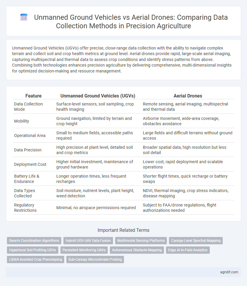
Table of Comparison
| Feature | Unmanned Ground Vehicles (UGVs) | Aerial Drones |
|---|---|---|
| Data Collection Mode | Surface-level sensors, soil sampling, crop health imaging | Remote sensing, aerial imaging, multispectral and thermal data |
| Mobility | Ground navigation, limited by terrain and crop height | Airborne movement, wide-area coverage, obstacles avoidance |
| Operational Area | Small to medium fields, accessible paths required | Large fields and difficult terrains without ground access |
| Data Precision | High precision at plant level, detailed soil and crop metrics | Broader spatial data, high resolution but less soil detail |
| Deployment Cost | Higher initial investment, maintenance of ground hardware | Lower cost, rapid deployment and scalable operations |
| Battery Life & Endurance | Longer operation times, less frequent recharges | Shorter flight times, quick recharge or battery swaps |
| Data Types Collected | Soil moisture, nutrient levels, plant height, weed detection | NDVI, thermal imaging, crop stress indicators, disease mapping |
| Regulatory Restrictions | Minimal, no airspace permissions required | Subject to FAA/drone regulations, flight authorizations needed |
Introduction to Precision Agriculture Technologies
Unmanned Ground Vehicles (UGVs) and aerial drones represent key technologies in precision agriculture, each offering unique advantages for data collection and field monitoring. UGVs provide detailed, close-range soil and crop data through sensor arrays and can operate in various weather conditions, enhancing precision in nutrient management and pest detection. Aerial drones cover larger areas quickly, delivering high-resolution imagery and real-time crop health analytics, essential for efficient field scouting and variable-rate application planning.
Role of Data Collection in Modern Farming
Unmanned Ground Vehicles (UGVs) offer precise soil sampling and close-range plant health monitoring, enabling detailed data collection for variable rate applications and real-time decision making in precision agriculture. Aerial drones excel in capturing high-resolution multispectral and thermal imagery over large fields quickly, supporting crop stress detection, yield estimation, and comprehensive field mapping. Integrating data from both UGVs and drones enhances the accuracy and scope of farm management systems, optimizing resource use and boosting overall crop productivity.
Overview of Unmanned Ground Vehicles (UGVs)
Unmanned Ground Vehicles (UGVs) are autonomous or remotely operated machines designed to navigate agricultural fields for precise data collection. Equipped with advanced sensors such as LiDAR, multispectral cameras, and soil probes, UGVs provide detailed information on soil health, crop vigor, and pest presence directly at ground level. They offer advantages in stability and prolonged operation time compared to aerial drones, enabling comprehensive monitoring in complex terrains and under dense crop canopies.
Capabilities of Aerial Drones in Agriculture
Aerial drones excel in capturing high-resolution multispectral and thermal images for precise crop health monitoring and early disease detection. Equipped with advanced sensors and GPS technology, drones enable rapid, large-scale data collection across diverse terrains with minimal soil compaction. Their ability to provide real-time, geo-referenced data enhances decision-making in irrigation management, pest control, and yield prediction within precision agriculture.
Comparative Accuracy: UGVs vs Aerial Drones
Unmanned Ground Vehicles (UGVs) provide higher accuracy in data collection for precision agriculture due to their close proximity to crops, enabling detailed soil and plant measurements with minimal signal interference. Aerial drones cover larger areas quickly but often face limitations in data resolution and precision caused by altitude and environmental factors like wind and lighting. Integrating UGVs and drones can optimize data accuracy by balancing ground-level detail with aerial spatial coverage.
Data Types and Sensors: Ground vs Air Platforms
Unmanned Ground Vehicles (UGVs) in precision agriculture leverage proximity sensors such as soil moisture probes, ground-penetrating radar, and hyperspectral cameras to capture detailed, high-resolution soil and crop health data. Aerial drones utilize multispectral, thermal, and LiDAR sensors to efficiently gather broad-area canopy imaging, crop stress analysis, and topographical mapping from above. The synergy of UGVs' fine-scale soil or root-zone information and drones' extensive aerial datasets enables comprehensive, multi-layered agricultural monitoring.
Efficiency and Coverage: UGVs Compared to Drones
Unmanned Ground Vehicles (UGVs) provide detailed, close-range data collection with high accuracy by navigating crop rows and soil surfaces, enhancing precision monitoring of plant health and soil conditions. In contrast, aerial drones cover larger areas quickly, offering broad spatial data but sometimes at lower resolution due to altitude and sensor limitations. UGVs excel in efficiency for targeted, ground-level tasks, while drones optimize coverage for rapid assessment across extensive farmland landscapes.
Operational Limitations and Challenges
Unmanned Ground Vehicles face operational limitations such as terrain navigation challenges, slower coverage speeds, and susceptibility to soil conditions, impacting data collection efficiency. Aerial drones encounter constraints including flight time restrictions due to battery life, regulatory airspace compliance, and vulnerability to adverse weather conditions, which can limit data acquisition windows. Both platforms require robust sensor integration and real-time data processing capabilities to overcome these challenges for effective precision agriculture applications.
Cost-Effectiveness and ROI Analysis
Unmanned Ground Vehicles (UGVs) in precision agriculture offer higher data accuracy and soil interaction capabilities at a lower initial investment compared to aerial drones, enhancing cost-effectiveness for detailed crop monitoring. Aerial drones provide rapid large-area coverage but involve higher operational costs and maintenance, potentially reducing short-term ROI in small-scale farms. Analyzing ROI reveals that UGVs deliver better long-term value through precise data collection and minimized labor expenses, particularly in complex terrains and precision input application.
Future Trends: Integration and Smart Farm Ecosystems
Unmanned Ground Vehicles (UGVs) and aerial drones are increasingly integrated within smart farm ecosystems to enhance precision agriculture through seamless data collection and analysis. Emerging trends emphasize the synchronization of UGVs for soil health monitoring and drones for aerial imaging, leveraging AI-driven analytics for real-time decision-making. Future smart farms utilize interconnected sensor networks and autonomous systems, enabling efficient resource management and sustainable crop production.
Related Important Terms
Swarm Coordination Algorithms
Swarm coordination algorithms enable Unmanned Ground Vehicles (UGVs) to efficiently navigate complex terrains while synchronizing tasks like soil analysis and crop monitoring, offering higher precision and localized data collection compared to aerial drones. In contrast, aerial drones rely on swarm algorithms to optimize flight paths and sensor coverage for rapid, large-scale imaging, but face limitations in ground-level detail and environmental interaction.
Hybrid UGV-UAV Data Fusion
Hybrid UGV-UAV data fusion combines the high-resolution, ground-level insights of Unmanned Ground Vehicles (UGVs) with the broad, aerial perspectives captured by Aerial Drones, enhancing precision agriculture data accuracy and decision-making. This integrated approach leverages multispectral sensors and real-time analytics to optimize crop monitoring, soil analysis, and resource management, driving higher yield and sustainability.
Multimodal Sensing Platforms
Unmanned Ground Vehicles (UGVs) in precision agriculture offer robust multimodal sensing platforms by integrating soil moisture sensors, nutrient analyzers, and high-resolution cameras to provide detailed, ground-level data for crop health and soil conditions. In contrast, aerial drones excel in capturing large-scale aerial imagery and thermal data, enabling rapid assessment of crop stress and irrigation uniformity, but often require complementary ground-based sensors to achieve comprehensive multimodal analysis.
Canopy-Level Spectral Mapping
Unmanned Ground Vehicles (UGVs) provide high-resolution canopy-level spectral mapping through close-range sensors, enabling precise detection of plant health and stress indicators with minimal atmospheric interference. Aerial drones cover larger areas rapidly using multispectral cameras but may face challenges in spectral data accuracy due to altitude and lighting variability.
Hyperlocal Soil Profiling UGVs
Unmanned Ground Vehicles (UGVs) provide superior accuracy in hyperlocal soil profiling through close-proximity sensor deployment and real-time soil data collection at various depths, enabling precise nutrient management. Compared to aerial drones, UGVs offer enhanced spatial resolution and consistent ground-level measurements critical for optimizing crop health and yield in precision agriculture.
Persistent Monitoring UAVs
Unmanned Ground Vehicles (UGVs) excel in collecting detailed soil and crop-level data through close-proximity sensors, while Persistent Monitoring UAVs offer superior aerial surveillance with continuous, real-time crop health analytics over large agricultural expanses. Persistent Monitoring UAVs enhance precision agriculture by providing high-frequency, multispectral imaging that enables timely interventions and optimized resource management.
Autonomous Obstacle Mapping
Unmanned Ground Vehicles (UGVs) excel in Precision Agriculture by providing detailed autonomous obstacle mapping through advanced LiDAR and radar sensors, enabling precise navigation around crops and terrain irregularities. Aerial drones offer broader area coverage for data collection but face limitations in low-altitude obstacle detection, making UGVs more effective for real-time, ground-level obstacle mapping and maneuvering.
Edge AI In-Field Analytics
Unmanned Ground Vehicles equipped with Edge AI enable precise in-field analytics by processing soil and crop data on-site, reducing latency and data transmission needs compared to aerial drones. Aerial drones complement this by capturing high-resolution aerial imagery for large-scale monitoring, but their reliance on cloud-based analytics often introduces delays in decision-making.
LiDAR-Assisted Crop Phenotyping
Unmanned Ground Vehicles (UGVs) equipped with LiDAR sensors provide high-resolution, close-proximity crop phenotyping data, capturing detailed plant structure and growth patterns more accurately than aerial drones. Aerial drones offer broader spatial coverage but often lack the precision in LiDAR-assisted phenotyping needed to assess intricate crop traits at the individual plant level.
Sub-Canopy Microclimate Probing
Unmanned Ground Vehicles (UGVs) provide precise sub-canopy microclimate data collection by navigating beneath crop canopies, enabling detailed measurements of temperature, humidity, and light conditions critical for crop health analysis. In contrast, aerial drones offer broader spatial coverage but face limitations in capturing fine-scale microclimate variations under dense foliage due to height and sensor positioning constraints.
Unmanned Ground Vehicles vs Aerial Drones for data collection Infographic