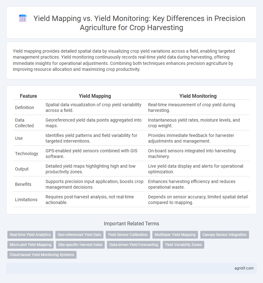
Yield mapping provides detailed spatial data by visualizing crop yield variations across a field, enabling targeted management practices. Yield monitoring continuously records real-time yield data during harvesting, offering immediate insights for operational adjustments. Combining both techniques enhances precision agriculture by improving resource allocation and maximizing crop productivity.
Table of Comparison
| Feature | Yield Mapping | Yield Monitoring |
|---|---|---|
| Definition | Spatial data visualization of crop yield variability across a field. | Real-time measurement of crop yield during harvesting. |
| Data Collected | Georeferenced yield data points aggregated into maps. | Instantaneous yield rates, moisture levels, and crop weight. |
| Use | Identifies yield patterns and field variability for targeted interventions. | Provides immediate feedback for harvester adjustments and management. |
| Technology | GPS-enabled yield sensors combined with GIS software. | On-board sensors integrated into harvesting machinery. |
| Output | Detailed yield maps highlighting high and low productivity zones. | Live yield data display and alerts for operational optimization. |
| Benefits | Supports precision input application, boosts crop management decisions. | Enhances harvesting efficiency and reduces operational waste. |
| Limitations | Requires post-harvest analysis, not real-time actionable. | Depends on sensor accuracy, limited spatial detail compared to mapping. |
Understanding Yield Mapping in Precision Agriculture
Yield mapping in precision agriculture involves creating detailed spatial representations of crop productivity by collecting data during harvest through GPS-linked yield monitors. This technique enables farmers to visualize yield variability within fields, facilitating targeted decision-making to enhance input efficiency and crop management. Unlike yield monitoring, which records real-time crop output, yield mapping processes and analyzes this data to produce actionable maps for optimizing agricultural practices.
What is Yield Monitoring?
Yield monitoring is the real-time collection of crop yield data during harvesting using sensors mounted on harvesting equipment, enabling precise measurement of grain flow and moisture content. This technology provides spatial variability insights by recording yield variations across different field zones, which helps farmers make informed management decisions. Yield monitoring forms the foundational data layer that supports yield mapping and advanced precision agriculture practices.
Key Differences Between Yield Mapping and Yield Monitoring
Yield mapping involves generating detailed geospatial data that visualizes crop yield variability across a field, enabling precise zone management and targeted intervention. Yield monitoring collects real-time data on crop output during harvest using sensors and yield monitors but lacks the comprehensive spatial analysis of yield maps. The key difference lies in yield mapping providing actionable insights through spatial patterns, while yield monitoring primarily tracks instantaneous harvesting performance.
Importance of Accurate Data in Crop Harvesting
Accurate data in crop harvesting enhances decision-making by differentiating yield mapping and yield monitoring roles; yield mapping provides spatial distribution patterns of crop productivity, while yield monitoring collects real-time data on crop performance during harvest. Precision agriculture relies on integrating these data sets to optimize resource allocation, improve harvest efficiency, and maximize profitability. Implementing accurate yield data supports sustainable farming practices by identifying field variability and enabling targeted interventions.
Technologies Used in Yield Mapping Systems
Yield mapping systems in precision agriculture utilize GPS technology combined with yield sensors such as optical, acoustic, or capacitive sensors to collect spatial yield data during crop harvesting. These systems integrate real-time data from combine harvesters, including grain flow rate and moisture content, creating detailed field maps that visualize yield variability. Advanced yield mapping technologies often incorporate Geographic Information System (GIS) software and wireless data transmission for efficient data analysis and decision-making.
Real-Time Benefits of Yield Monitoring
Yield monitoring provides real-time data on crop yield, moisture levels, and machine performance during harvesting, enabling immediate decision-making and adjustments to optimize efficiency. Yield mapping, in contrast, compiles spatial yield data post-harvest, useful for long-term analysis but lacking instant actionable insights. Real-time yield monitoring minimizes resource waste, reduces operational costs, and improves overall crop management by facilitating timely interventions during the harvesting process.
Data Analysis and Interpretation: Mapping vs Monitoring
Yield mapping provides spatially explicit data by integrating GPS coordinates with crop yield measurements, enabling precise visualization of yield variability across fields. Yield monitoring collects real-time data during harvesting, focusing on instantaneous yield rates and machine performance metrics. Data analysis in yield mapping emphasizes spatial pattern recognition and trend identification, while yield monitoring prioritizes temporal data flow and operational efficiency assessment.
Impact on Farm Management Decisions
Yield mapping integrates GPS data with yield monitor outputs to create spatially detailed maps of crop yield variability across fields, enabling precise identification of high and low productivity zones. Yield monitoring collects real-time data on crop yield but lacks spatial analysis, limiting insights into variable field conditions. Utilizing yield mapping enhances farm management decisions by supporting site-specific interventions, optimizing input use, and improving overall crop performance.
Challenges and Limitations of Each Approach
Yield mapping faces challenges such as high equipment costs, GPS signal inaccuracies, and data complexity that complicate precise spatial analysis. Yield monitoring is limited by sensor calibration errors, varying crop conditions, and incomplete data coverage that reduce measurement accuracy. Both approaches require significant technical expertise and data management resources to effectively support decision-making in crop harvesting.
Future Trends in Yield Data Collection
Yield mapping integrates GPS and sensor data to create detailed spatial representations of crop productivity, enabling targeted decision-making and enhanced resource management. Yield monitoring collects real-time data during harvesting, focusing on yield quantity and quality aspects for immediate operational adjustments. Future trends emphasize AI-driven data analytics and IoT-enabled sensor networks, improving precision in yield predictions and fostering adaptive management strategies in precision agriculture.
Related Important Terms
Real-time Yield Analytics
Yield mapping involves creating detailed spatial maps of crop yields by aggregating data post-harvest, providing valuable insights into field variability. Yield monitoring offers real-time yield analytics during crop harvesting, enabling immediate adjustments to machinery and farming practices to optimize productivity and resource use.
Geo-referenced Yield Data
Geo-referenced yield data in yield mapping provides spatial variability insights by capturing precise location-based crop performance, enabling targeted field management and optimized resource allocation. Yield monitoring collects real-time harvest data but lacks the detailed spatial analysis yield mapping offers for identifying yield patterns across different field zones.
Yield Sensor Calibration
Yield mapping utilizes geospatial data combined with calibrated yield sensors to create precise field variability maps, while yield monitoring relies on real-time data collection from sensors during harvest without detailed spatial analysis. Proper yield sensor calibration ensures accurate grain flow measurements, minimizing errors in both yield mapping and monitoring to enhance decision-making in precision agriculture.
Multilayer Yield Mapping
Multilayer yield mapping enhances crop harvesting precision by integrating spatial data from yield monitoring systems with additional layers such as soil variability, weather patterns, and crop health indexes to provide a comprehensive analysis of yield distribution. Yield monitoring captures real-time data on crop output during harvesting, while multilayer yield mapping processes this information alongside environmental and agronomic factors, enabling targeted decision-making and optimized resource allocation.
Canopy Sensor Integration
Yield mapping leverages GPS and yield monitor data to create spatially precise crop productivity maps, enabling variable rate applications based on field variability. Integrating canopy sensors with yield monitoring enhances real-time data accuracy by capturing plant health and biomass metrics, thereby optimizing harvest decisions and improving input efficiency in precision agriculture.
Micro-plot Yield Mapping
Micro-plot yield mapping provides high-resolution spatial data on crop performance within small management zones, enabling precise identification of variability in yield during harvest. Yield monitoring captures real-time overall crop output but lacks the granularity of micro-plot mapping essential for targeted field management decisions in precision agriculture.
Site-specific Harvest Index
Yield mapping provides spatially detailed data on crop output variability across fields, enabling precise site-specific harvest index calculations that optimize resource allocation. Yield monitoring collects real-time grain yield and moisture data during harvesting, supporting immediate decision-making but lacks the comprehensive spatial analysis crucial for improving site-specific harvest efficiency.
Data-driven Yield Forecasting
Yield mapping captures spatial variability in crop production by creating detailed georeferenced yield data during harvest, enabling precise analysis of field performance. Yield monitoring collects real-time harvesting data using sensors and combines it with historical and environmental datasets for advanced data-driven yield forecasting models, improving accuracy in predicting crop output.
Yield Variability Zones
Yield monitoring collects real-time data on crop yields throughout the harvesting process, enabling identification of spatial yield variability within the field. Yield mapping organizes this data into detailed, GPS-referenced maps that highlight distinct yield variability zones, allowing farmers to implement site-specific management practices to optimize productivity and resource use.
Cloud-based Yield Monitoring Systems
Cloud-based yield monitoring systems enhance crop harvesting by providing real-time data collection and analysis, surpassing traditional yield mapping's periodic data snapshots. These platforms enable seamless integration of GPS, sensors, and machine learning algorithms, optimizing field-level decision-making and improving overall yield accuracy.
Yield Mapping vs Yield Monitoring for Crop Harvesting Infographic