Yield mapping provides a spatial representation of crop performance by collecting data on yield variations across different field zones, enabling targeted management practices. Yield monitoring continuously records real-time data during harvest, helping farmers identify patterns and anomalies in crop productivity for immediate decision-making. Combining both techniques enhances precision agriculture by offering detailed insights into yield distribution and overall crop health.
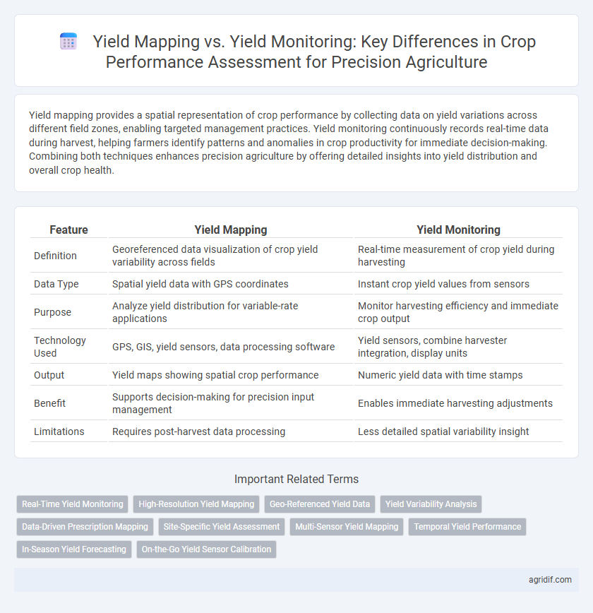
Table of Comparison
| Feature | Yield Mapping | Yield Monitoring |
|---|---|---|
| Definition | Georeferenced data visualization of crop yield variability across fields | Real-time measurement of crop yield during harvesting |
| Data Type | Spatial yield data with GPS coordinates | Instant crop yield values from sensors |
| Purpose | Analyze yield distribution for variable-rate applications | Monitor harvesting efficiency and immediate crop output |
| Technology Used | GPS, GIS, yield sensors, data processing software | Yield sensors, combine harvester integration, display units |
| Output | Yield maps showing spatial crop performance | Numeric yield data with time stamps |
| Benefit | Supports decision-making for precision input management | Enables immediate harvesting adjustments |
| Limitations | Requires post-harvest data processing | Less detailed spatial variability insight |
Introduction to Precision Agriculture: Yield Mapping and Monitoring
Yield mapping in precision agriculture involves spatially recording crop yields using GPS-enabled combines to create detailed field variability maps. Yield monitoring collects real-time data on crop performance during harvesting, allowing immediate assessment of productivity and identification of problem areas. Together, these technologies optimize decision-making by providing precise, location-specific insights for enhancing crop management and increasing farm profitability.
Defining Yield Mapping and Yield Monitoring
Yield mapping involves creating detailed spatial representations of crop yield variations across a field using GPS and sensor data, enabling precise analysis of productivity patterns. Yield monitoring refers to the real-time collection of yield data during harvesting, capturing measurements such as grain weight, moisture content, and flow rate. Both technologies are essential for crop performance assessment, providing critical insights for targeted interventions and improved farm management.
Core Technologies Behind Yield Mapping and Monitoring
Yield mapping relies on GPS technology and combine harvester sensors to record spatial yield data, enabling precise field variability analysis. Yield monitoring integrates real-time sensor data such as moisture content, grain flow, and machine speed, facilitating immediate assessment of crop performance during harvest. Both technologies utilize embedded software and data analytics platforms to optimize input application and maximize output efficiency in precision agriculture.
Data Collection Methods: Yield Mapping vs Yield Monitoring
Yield mapping employs GPS technology combined with yield sensors on harvesting equipment to create spatially detailed maps of crop yield variability across fields. Yield monitoring continuously records real-time data on crop output, such as grain flow rate and moisture content, enabling immediate performance evaluation during harvest. Both methods rely on advanced sensors and data loggers, but yield mapping emphasizes post-harvest spatial analysis while yield monitoring focuses on instantaneous crop performance assessment.
Accuracy and Resolution: Comparing Yield Data Quality
Yield mapping offers higher spatial resolution by collecting yield data at precise GPS-referenced locations, enabling detailed variability analysis across the field. Yield monitoring provides real-time yield data during harvesting but may have lower positional accuracy due to equipment calibration and sensor limitations. Enhanced accuracy and resolution in yield mapping improve crop performance assessment by enabling targeted management decisions and optimizing input use.
Key Benefits of Yield Mapping for Crop Assessment
Yield mapping provides spatially detailed data on crop performance, enabling farmers to identify variability within fields and optimize input application. It enhances decision-making by offering precise insights into yield distribution patterns, which can improve nutrient management and irrigation scheduling. This targeted approach increases overall productivity and sustainability in precision agriculture.
Advantages of Yield Monitoring in Farm Management
Yield monitoring provides real-time data collection on crop performance, allowing farmers to make immediate decisions that optimize resource use and improve overall productivity. Its continuous data stream supports precise adjustments in irrigation, fertilization, and pest control, enhancing crop health and yield consistency. Yield monitoring's high-resolution insights enable targeted interventions, reducing waste and increasing profitability in precision agriculture.
Challenges and Limitations of Each Approach
Yield mapping faces challenges such as GPS signal inaccuracies and data processing complexity, which can lead to inconsistent spatial representations of crop performance. Yield monitoring often struggles with sensor calibration errors and equipment maintenance, resulting in potential measurement inaccuracies during harvesting. Both approaches have limitations in capturing real-time variations and require integration with other precision agriculture tools to improve overall crop performance assessment.
Integrating Yield Mapping and Monitoring for Optimal Results
Integrating yield mapping and yield monitoring enhances crop performance assessment by combining spatial data with real-time yield measurements, enabling precise identification of field variability and management zones. Advanced GPS and sensor technologies facilitate detailed yield maps that correlate with monitored data, improving decision-making for fertilizer application, irrigation, and pest control. This synergy supports precision agriculture strategies that optimize resource use, increase productivity, and reduce environmental impact.
Future Trends in Crop Performance Assessment Technology
Yield mapping integrates geospatial data with real-time yield measurements to create detailed spatial yield variability maps, enhancing precision agriculture's decision-making processes. Emerging technologies like AI-driven analytics and drone-based multispectral imaging are poised to revolutionize yield monitoring by providing higher-resolution, real-time crop performance data. Future trends emphasize combining yield mapping with advanced sensor fusion and predictive modeling to optimize resource allocation and improve crop productivity sustainably.
Related Important Terms
Real-Time Yield Monitoring
Real-time yield monitoring provides immediate, high-resolution data on crop performance across fields, enabling precise adjustments during harvest to optimize output and resource use. Yield mapping compiles this data into spatially referenced maps post-harvest, facilitating detailed analysis of yield variability for future management decisions.
High-Resolution Yield Mapping
High-resolution yield mapping provides detailed spatial variability data by capturing precise yield measurements across different field zones, enabling targeted management and optimized input application. Unlike general yield monitoring, yield mapping enhances crop performance assessment through granular insights, facilitating improved decision-making for precision agriculture.
Geo-Referenced Yield Data
Yield mapping generates detailed geo-referenced yield data by integrating GPS technology with combine harvesters, enabling precise spatial analysis of crop performance across fields. Yield monitoring collects real-time crop yield information during harvest but lacks the spatial detail necessary for comprehensive field variability assessment, making yield mapping essential for site-specific management decisions.
Yield Variability Analysis
Yield mapping provides spatially detailed data that reveals intra-field yield variability, enabling precise identification of high and low performing zones, while yield monitoring offers real-time crop performance insights but lacks the granular spatial context crucial for comprehensive variability analysis. Advanced yield mapping integrates GPS and sensor data to generate high-resolution yield variability maps, facilitating targeted management decisions to optimize crop productivity and resource use efficiency.
Data-Driven Prescription Mapping
Yield mapping collects spatial data on crop productivity across fields using combine harvesters equipped with GPS and yield sensors, enabling detailed visualization of yield variability. Yield monitoring continuously records real-time crop yield and moisture data during harvesting, providing essential inputs for data-driven prescription mapping to optimize nutrient application and irrigation strategies for enhanced crop performance.
Site-Specific Yield Assessment
Yield mapping employs GPS and sensor data to create detailed spatial representations of crop performance, enabling site-specific yield assessment that identifies field variability and supports targeted management practices. Yield monitoring collects real-time data during harvesting but lacks the spatial resolution of yield mapping, making it less effective for precise, site-specific analysis and variable rate applications.
Multi-Sensor Yield Mapping
Multi-sensor yield mapping integrates data from various sensors such as GNSS, optical, and moisture sensors to produce high-resolution spatial yield variability maps, enhancing the accuracy of crop performance assessment compared to traditional single-sensor yield monitoring. This approach enables precise identification of yield-limiting factors and supports site-specific management decisions, optimizing inputs and maximizing agricultural productivity.
Temporal Yield Performance
Yield mapping provides spatial and temporal data by recording crop yield variations across different field zones throughout the growing season, enabling precise assessment of temporal yield performance. Yield monitoring collects real-time yield data during harvest, supporting immediate analysis of crop performance trends over time but with less spatial resolution compared to yield mapping.
In-Season Yield Forecasting
Yield mapping collects spatial yield data during harvest to analyze crop variability, while yield monitoring uses real-time sensors to estimate yield continuously throughout the growing season, enabling more accurate in-season yield forecasting. Integrating yield monitoring with advanced analytics improves decision-making by providing timely insights into crop performance for precision agriculture management.
On-the-Go Yield Sensor Calibration
On-the-go yield sensor calibration enhances the accuracy of yield monitoring by continuously adjusting sensor readings to reflect real-time field variability, enabling precise crop performance assessment. Yield mapping leverages this calibrated data to generate spatially detailed yield distribution maps, facilitating targeted management decisions and improved resource allocation.
Yield Mapping vs Yield Monitoring for Crop Performance Assessment Infographic