Yield mapping provides detailed data on crop performance variations across a field, enabling targeted interventions to optimize productivity and manage resources efficiently. Soil mapping offers critical insights into soil properties such as texture, nutrient levels, and moisture retention, supporting informed decisions on fertilization and irrigation tailored to specific zones. Combining yield mapping with soil mapping enhances site-specific management by aligning crop data with soil conditions to maximize yield potential and sustainability.
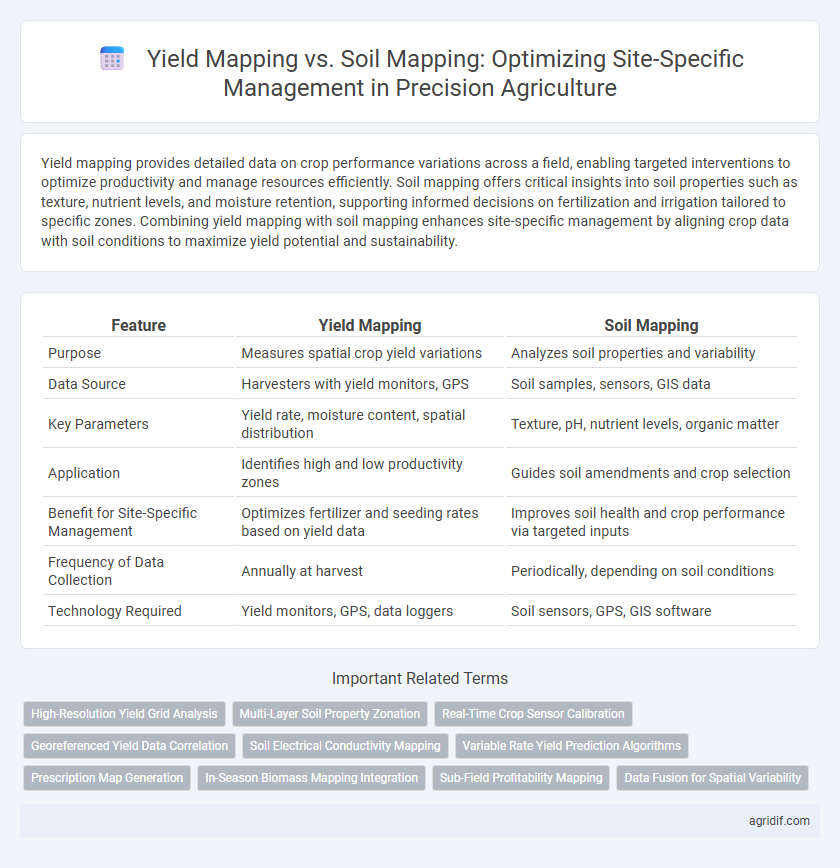
Table of Comparison
| Feature | Yield Mapping | Soil Mapping |
|---|---|---|
| Purpose | Measures spatial crop yield variations | Analyzes soil properties and variability |
| Data Source | Harvesters with yield monitors, GPS | Soil samples, sensors, GIS data |
| Key Parameters | Yield rate, moisture content, spatial distribution | Texture, pH, nutrient levels, organic matter |
| Application | Identifies high and low productivity zones | Guides soil amendments and crop selection |
| Benefit for Site-Specific Management | Optimizes fertilizer and seeding rates based on yield data | Improves soil health and crop performance via targeted inputs |
| Frequency of Data Collection | Annually at harvest | Periodically, depending on soil conditions |
| Technology Required | Yield monitors, GPS, data loggers | Soil sensors, GPS, GIS software |
Understanding Precision Agriculture: An Overview
Yield mapping utilizes GPS and harvest data to create detailed spatial representations of crop productivity, enabling farmers to identify high and low yielding zones within their fields. Soil mapping captures variability in soil properties like texture, pH, and nutrient content through sampling and sensor technology, providing essential information for tailored field management. Both yield mapping and soil mapping are integral components of precision agriculture, driving site-specific strategies that optimize inputs, improve crop performance, and enhance sustainable farming practices.
What is Yield Mapping?
Yield mapping involves the collection and analysis of crop yield data using GPS-enabled harvesters to create spatially detailed maps that highlight variations in productivity across a field. This technology enables farmers to identify high and low-yield zones, optimizing inputs like fertilizers and irrigation for site-specific management. Yield mapping is crucial for making informed decisions that enhance overall farm efficiency and crop performance.
What is Soil Mapping?
Soil mapping involves the detailed analysis and spatial representation of soil properties such as texture, moisture, nutrient levels, and pH across agricultural fields to guide site-specific management decisions. By capturing variability in soil characteristics, soil mapping enables precise application of inputs like fertilizers, irrigation, and amendments, optimizing crop growth conditions while minimizing waste and environmental impact. This geospatial soil data is essential for creating variable rate prescription maps that enhance yield potential and sustainability in precision agriculture.
Key Technologies Behind Yield and Soil Mapping
Yield mapping relies on GPS-guided harvesters equipped with yield monitors and sensors that measure crop output in real time, creating detailed spatial yield data. Soil mapping uses geospatial technologies like electromagnetic induction sensors, soil probes, and satellite imagery to assess soil properties such as texture, moisture, and nutrient levels across fields. Both technologies integrate Geographic Information Systems (GIS) and data analytics for precise site-specific management, enabling tailored input applications to optimize crop production and soil health.
Data Collection Methods: Yield vs Soil Mapping
Yield mapping utilizes combine-mounted GPS and yield monitors to collect real-time data on crop output variability across fields, enabling precise spatial analysis of productivity. Soil mapping involves systematic sampling and sensor technologies, such as electromagnetic induction and resistivity probes, to gather detailed soil property information like texture, moisture, and nutrient levels. Both methods require GPS integration and data processing software, but yield mapping emphasizes real-time harvest data, while soil mapping focuses on pre-planting soil condition assessments for site-specific management.
Accuracy and Resolution: Comparing Mapping Approaches
Yield mapping offers high accuracy in capturing spatial variability of crop performance through real-time harvest data, enabling precise site-specific management decisions. Soil mapping provides detailed resolution of soil properties such as texture, nutrient levels, and moisture content, essential for predicting crop response and optimizing input application. Combining both methods enhances the overall precision of field management by integrating crop yield outcomes with underlying soil conditions for targeted interventions.
Benefits of Yield Mapping for Site-Specific Management
Yield mapping provides detailed spatial data on crop performance, enabling farmers to identify high and low productivity zones for precise resource allocation. This technology enhances decision-making by correlating yield variations with specific field conditions, improving fertilizer application and irrigation efficiency. As a result, yield mapping supports sustainable practices and maximizes profitability through targeted site-specific management.
Advantages of Soil Mapping in Precision Agriculture
Soil mapping in precision agriculture offers detailed insights into soil properties such as texture, moisture, nutrient levels, and pH variations, enabling targeted input application and improved crop management. This approach enhances site-specific management by identifying soil variability within fields, which helps optimize fertilizer use and irrigation scheduling, thereby increasing yield potential and reducing environmental impact. Compared to yield mapping, soil mapping provides proactive data for decision-making before planting, allowing farmers to tailor their strategies for sustainable productivity.
Challenges and Limitations: Yield vs Soil Mapping
Yield mapping faces challenges such as variability in sensor accuracy, malfunctioning equipment, and the influence of weather conditions on data reliability, which can limit precise site-specific management. Soil mapping encounters limitations related to spatial resolution, sampling density, and the heterogeneity of soil properties, making it difficult to capture detailed nutrient and texture variations at a fine scale. Both methods require substantial data integration and calibration efforts to improve decision-making accuracy in precision agriculture.
Integrating Yield and Soil Maps for Optimized Decision-Making
Integrating yield maps and soil maps enhances site-specific management by providing comprehensive insights into spatial variability of crop performance and soil properties. Yield mapping captures real-time data on crop productivity, while soil mapping identifies nutrient levels, texture, and moisture retention, allowing precise application of inputs. This synergistic approach optimizes resource use, maximizes yield potential, and fosters sustainable agricultural practices through data-driven decision-making.
Related Important Terms
High-Resolution Yield Grid Analysis
High-resolution yield grid analysis offers detailed spatial data enabling precise identification of crop performance variability within fields, crucial for optimizing site-specific management decisions. Yield mapping captures actual plant productivity patterns, while soil mapping provides static soil property data; integrating both enhances targeted input application but yield mapping's real-time data offers superior responsiveness to in-season conditions.
Multi-Layer Soil Property Zonation
Yield mapping provides spatially variable crop performance data by utilizing GPS and yield monitors during harvest, offering real-time insights into field productivity patterns. Soil mapping, especially through multi-layer soil property zonation combining texture, organic matter, and moisture retention layers, enables precise site-specific management by identifying sub-field variability crucial for tailored input applications.
Real-Time Crop Sensor Calibration
Yield mapping provides spatial data on crop output that helps identify high and low productivity zones, enhancing site-specific management accuracy. Real-time crop sensor calibration improves soil mapping precision by continuously adjusting sensor readings, enabling more accurate soil property assessments and targeted input applications.
Georeferenced Yield Data Correlation
Yield mapping utilizes georeferenced yield data to identify spatial variability in crop production, enabling precise correlation with soil properties obtained from soil mapping. This integration of yield and soil data enhances site-specific management by optimizing input application based on accurate, location-specific insights.
Soil Electrical Conductivity Mapping
Soil Electrical Conductivity (EC) mapping provides detailed spatial variations in soil properties such as texture, moisture, and salinity, enabling precise site-specific management decisions that optimize resource use and crop productivity. Unlike yield mapping, which reflects crop performance after growth, EC mapping offers proactive insights into soil variability, allowing for targeted interventions before planting and enhancing overall field management efficiency.
Variable Rate Yield Prediction Algorithms
Variable Rate Yield Prediction Algorithms leverage real-time yield mapping data combined with soil mapping attributes to enhance site-specific management decisions, optimizing input application based on spatial variability. Integrating high-resolution sensor data with soil property variations allows precise adjustment of fertilizers and irrigation, improving crop productivity and sustainability in precision agriculture.
Prescription Map Generation
Yield mapping captures spatial variability of crop production using harvest data, enabling accurate prescription map generation for variable-rate input applications. Soil mapping provides detailed information on soil properties and conditions, enhancing prescription maps by integrating soil variability to optimize nutrient management and improve site-specific recommendations.
In-Season Biomass Mapping Integration
Yield mapping provides spatial data on crop output at harvest, while soil mapping offers insights into soil properties influencing plant growth; integrating in-season biomass mapping enhances site-specific management by delivering real-time vegetation health and biomass measurements, enabling precise adjustments to inputs and improving overall crop performance. This combination optimizes nutrient application and irrigation by correlating biomass dynamics with yield potential and soil variability for more efficient and sustainable farming practices.
Sub-Field Profitability Mapping
Yield mapping captures spatial variability in crop output by integrating GPS data with harvesters, enabling precise identification of high- and low-yield zones, which is critical for sub-field profitability mapping; soil mapping complements this by detailing nutrient levels, texture, and moisture, allowing tailored input applications to optimize production costs and enhance economic returns within specific field segments. Combining yield and soil mapping data facilitates site-specific management decisions that maximize profitability by targeting resources efficiently and adapting practices to in-field variability.
Data Fusion for Spatial Variability
Yield mapping captures crop productivity variations by recording harvest data via GPS-enabled combines, while soil mapping characterizes spatial heterogeneity through sensor-based analysis of soil properties such as texture, moisture, and nutrient levels. Data fusion techniques integrate yield and soil maps to enhance spatial variability understanding, enabling site-specific management decisions that optimize input efficiency and improve crop performance.
Yield Mapping vs Soil Mapping for site-specific management Infographic