Satellite imagery provides broad, large-scale views that help monitor crop health and soil conditions over extensive areas with consistent temporal frequency. UAV (drone) imagery offers higher resolution and real-time data, enabling precise identification of issues like pest infestations and nutrient deficiencies at a localized level. Combining both technologies enhances farm scouting accuracy by leveraging satellite coverage and drone detail for optimized decision-making in precision agriculture.
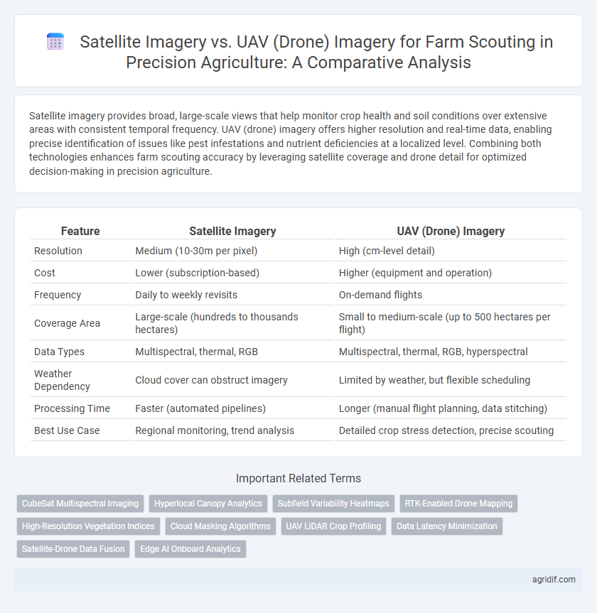
Table of Comparison
| Feature | Satellite Imagery | UAV (Drone) Imagery |
|---|---|---|
| Resolution | Medium (10-30m per pixel) | High (cm-level detail) |
| Cost | Lower (subscription-based) | Higher (equipment and operation) |
| Frequency | Daily to weekly revisits | On-demand flights |
| Coverage Area | Large-scale (hundreds to thousands hectares) | Small to medium-scale (up to 500 hectares per flight) |
| Data Types | Multispectral, thermal, RGB | Multispectral, thermal, RGB, hyperspectral |
| Weather Dependency | Cloud cover can obstruct imagery | Limited by weather, but flexible scheduling |
| Processing Time | Faster (automated pipelines) | Longer (manual flight planning, data stitching) |
| Best Use Case | Regional monitoring, trend analysis | Detailed crop stress detection, precise scouting |
Introduction to Remote Sensing in Precision Agriculture
Satellite imagery offers extensive spatial coverage and frequent temporal updates crucial for large-scale crop health monitoring, while UAV (drone) imagery provides higher spatial resolution and flexibility for detailed, site-specific farm scouting. Remote sensing in precision agriculture leverages these data sources to analyze vegetation indices, soil moisture, and pest infestations, enabling informed decision-making to optimize yield and resource usage. Integrating satellite and UAV imagery enhances accuracy in detecting crop stress and variability, facilitating targeted interventions that improve overall farm management efficiency.
Overview of Satellite Imagery for Farm Scouting
Satellite imagery for farm scouting offers extensive coverage and frequent revisit times, enabling large-scale monitoring of crop health and growth patterns. High-resolution multispectral and hyperspectral data provide vital insights into soil moisture, nutrient levels, and pest infestations across vast agricultural landscapes. This remote sensing technology supports precision agriculture by facilitating timely decision-making and optimizing resource allocation.
UAV (Drone) Imagery: Capabilities and Applications
UAV (drone) imagery offers high-resolution, real-time data critical for precision agriculture, enabling detailed crop health monitoring and timely pest or disease detection. Equipped with multispectral and thermal sensors, drones provide precise measurements of vegetation indices, soil moisture, and canopy temperature, facilitating targeted interventions that optimize yield. The flexibility of UAV deployment allows frequent, low-altitude flights that capture localized variations within fields, outperforming satellite imagery in spatial resolution and responsiveness.
Spatial Resolution: Satellites vs Drones in Field Analysis
Satellite imagery offers broader coverage with spatial resolutions typically ranging from 0.3 to 10 meters, suitable for large-scale crop monitoring and trend analysis. UAV (drone) imagery provides ultra-high spatial resolution, often below 5 centimeters per pixel, enabling detailed plant-level assessments and precise identification of stress factors. This difference in spatial resolution makes drone imagery ideal for localized field analysis, while satellite imagery is advantageous for regional-scale precision agriculture planning.
Temporal Resolution and Data Acquisition Frequency
UAV imagery offers higher temporal resolution with the ability to capture farm data multiple times per day, enabling real-time monitoring of crops and rapid response to stress conditions. Satellite imagery, while providing broader coverage, typically has lower temporal resolution, with revisit times ranging from days to weeks depending on the satellite constellation and weather conditions. Frequent data acquisition through drones facilitates precise, timely decision-making crucial for optimizing yield and resource management in precision agriculture.
Cost Comparison for Satellite and UAV Imagery
Satellite imagery offers a cost-effective solution for large-scale farm scouting, with subscription prices typically ranging from $10 to $30 per hectare annually, making it suitable for extensive crop monitoring. UAV (drone) imagery incurs higher upfront costs, including drone purchase, maintenance, and skilled operation, averaging $100 to $300 per flight per hectare, but provides higher resolution and on-demand data. While satellites reduce recurring expenses and cover broad areas efficiently, drones deliver more detailed imagery essential for precision interventions despite higher per-use costs.
Data Processing and Accessibility Challenges
Satellite imagery offers broad coverage and frequent revisit times but often suffers from lower resolution and cloud interference, complicating precise data analysis for farm scouting. UAV (drone) imagery provides high-resolution, customizable data that enhances detailed crop health monitoring, yet requires complex data processing and skilled operators, limiting accessibility for some farmers. Both platforms face challenges in seamlessly integrating data into user-friendly agricultural management systems to optimize decision-making and operational efficiency.
Specific Use Cases: When to Choose Satellites or Drones
Satellite imagery offers extensive coverage and frequent revisits, making it ideal for large-scale crop monitoring, detecting regional stress patterns, and assessing overall vegetation health. UAV (drone) imagery excels in high-resolution data capture, suitable for targeted scouting tasks such as pest detection, disease identification, and precise irrigation management in smaller fields. Choosing between satellites or drones depends on farm size, required image resolution, temporal frequency, and specific scouting objectives within precision agriculture.
Integrating Satellite and UAV Data for Enhanced Decision Making
Integrating satellite imagery with UAV (drone) data leverages the extensive spatial coverage of satellites and the high-resolution detail from drones to optimize farm scouting accuracy. Satellite imagery provides timely, large-scale monitoring of crop health, while UAV data delivers precise, localized insights for targeted interventions. Combining these data sources enhances decision-making by enabling comprehensive analysis of field conditions, improving yield predictions, and facilitating resource-efficient management practices.
Future Trends in Agricultural Remote Sensing Technologies
Satellite imagery offers extensive coverage and frequent data updates, making it ideal for large-scale farm scouting and monitoring crop health over vast areas. UAV (drone) imagery provides high-resolution, real-time data with flexible deployment, enabling precise detection of crop stress and pest infestations at the micro-level. Future trends point towards integrated remote sensing systems combining satellite and drone data with AI-driven analytics to enhance predictive accuracy and optimize resource management in precision agriculture.
Related Important Terms
CubeSat Multispectral Imaging
CubeSat multispectral imaging offers high-resolution, frequent satellite data crucial for identifying crop health variations and stress patterns across large farm areas, enabling precision agriculture scouting at scale. UAV imagery provides ultra-high-resolution, flexible deployment for localized field assessments, but CubeSat data complements it by delivering consistent, cost-effective multispectral coverage ideal for monitoring temporal changes in crop conditions.
Hyperlocal Canopy Analytics
Satellite imagery provides broad spatial coverage with moderate resolution suitable for monitoring large-scale crop patterns, while UAV imagery offers high-resolution, hyperlocal canopy analytics enabling precise detection of crop stress and variability at the individual plant level. Combining UAV-derived multispectral data with satellite time-series enhances decision-making accuracy by capturing both detailed canopy conditions and temporal growth trends.
Subfield Variability Heatmaps
Satellite imagery offers broad coverage and frequent revisits essential for generating subfield variability heatmaps, capturing large-scale crop health patterns and environmental conditions effectively. UAV imagery provides higher spatial resolution enabling precise detection of micro-variability within subfields, enhancing the accuracy of heatmaps for targeted farm scouting and intervention.
RTK-Enabled Drone Mapping
RTK-enabled drone mapping offers centimeter-level GPS accuracy, enabling precise farm scouting and crop health monitoring unmatched by traditional satellite imagery, which is often limited by lower resolution and cloud interference. This high-precision UAV data supports detailed field variability analysis, optimizing input application and improving yield prediction in precision agriculture.
High-Resolution Vegetation Indices
Satellite imagery offers extensive coverage with moderate resolution suitable for large-scale vegetation indices, while UAV (drone) imagery provides high-resolution data critical for detailed farm scouting and precise monitoring of crop health. High-resolution vegetation indices derived from UAV imagery enable early detection of stress factors such as nutrient deficiencies, pest infestations, and irrigation issues, enhancing targeted interventions and improving overall crop management.
Cloud Masking Algorithms
Satellite imagery for farm scouting leverages advanced cloud masking algorithms that analyze spectral signatures to exclude cloud-covered pixels, ensuring accurate crop health assessment over large areas; UAV imagery, while offering higher resolution, requires real-time onboard or post-processing cloud detection techniques that integrate machine learning models for precise cloud removal in variable atmospheric conditions. Efficient cloud masking enhances data reliability, enabling precision agriculture practices to optimize resource allocation and improve yield predictions by minimizing false signals caused by cloud interference.
UAV LiDAR Crop Profiling
UAV LiDAR crop profiling offers high-resolution, three-dimensional data capturing precise plant height and canopy structure, surpassing traditional satellite imagery in spatial accuracy and temporal flexibility for farm scouting. This advanced aerial technology enables detailed vegetation analysis and stress detection, optimizing crop management and yield predictions with real-time, site-specific insights.
Data Latency Minimization
Satellite imagery provides broad coverage but often suffers from data latency due to infrequent passes and processing time, limiting real-time decision-making in precision agriculture. UAV (drone) imagery minimizes data latency by offering rapid deployment and on-demand high-resolution images, enabling timely farm scouting and immediate intervention.
Satellite-Drone Data Fusion
Satellite imagery offers broad, high-frequency coverage for crop monitoring, while UAV imagery provides high-resolution, localized data essential for detailed farm scouting. Combining satellite and drone data through fusion techniques enhances precision agriculture by integrating comprehensive spatial-temporal insights with fine-scale variability analysis, optimizing decision-making and resource management.
Edge AI Onboard Analytics
Satellite imagery provides broad, multispectral data with lower spatial resolution ideal for regional crop monitoring, while UAV imagery delivers high-resolution, real-time visuals suited for detailed farm scouting. Edge AI onboard drones processes data instantly at the source, enabling rapid detection of crop stress and pests, minimizing latency compared to satellite-based analytics.
Satellite Imagery vs UAV (Drone) Imagery for Farm Scouting Infographic