Drones offer greater maneuverability and precision for aerial surveying in precision agriculture, making them ideal for capturing high-resolution images of small to medium-sized fields. Fixed-wing aircraft cover larger areas faster, providing cost-effective data collection for extensive farmland but with less detailed imaging. Choosing between the two depends on farm size, budget, and the specific data accuracy required for crop monitoring and management.
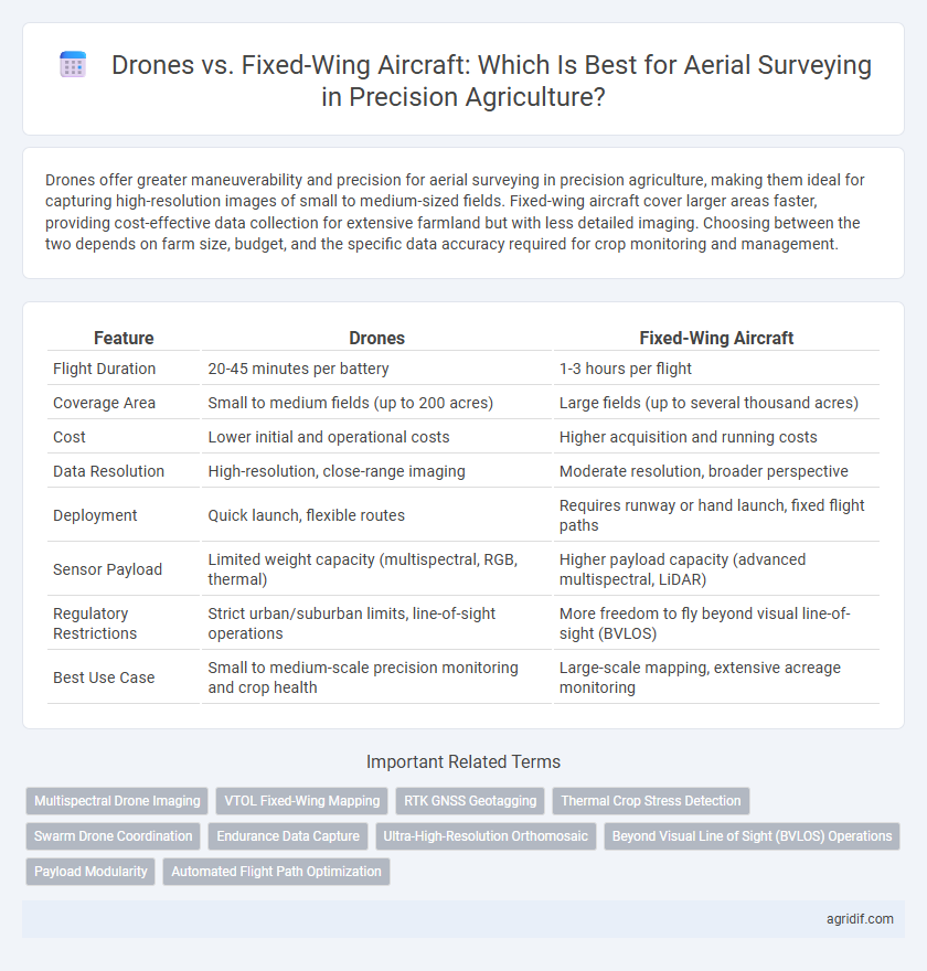
Table of Comparison
| Feature | Drones | Fixed-Wing Aircraft |
|---|---|---|
| Flight Duration | 20-45 minutes per battery | 1-3 hours per flight |
| Coverage Area | Small to medium fields (up to 200 acres) | Large fields (up to several thousand acres) |
| Cost | Lower initial and operational costs | Higher acquisition and running costs |
| Data Resolution | High-resolution, close-range imaging | Moderate resolution, broader perspective |
| Deployment | Quick launch, flexible routes | Requires runway or hand launch, fixed flight paths |
| Sensor Payload | Limited weight capacity (multispectral, RGB, thermal) | Higher payload capacity (advanced multispectral, LiDAR) |
| Regulatory Restrictions | Strict urban/suburban limits, line-of-sight operations | More freedom to fly beyond visual line-of-sight (BVLOS) |
| Best Use Case | Small to medium-scale precision monitoring and crop health | Large-scale mapping, extensive acreage monitoring |
Introduction: The Evolution of Aerial Surveying in Precision Agriculture
Drones and fixed-wing aircraft have revolutionized aerial surveying in precision agriculture by enabling detailed crop monitoring and data collection. Drones offer high-resolution imagery and flexibility for small to medium-sized fields, while fixed-wing aircraft provide broader coverage and longer flight times suited for extensive farmland. These technologies improve decision-making by delivering precise, real-time data on crop health, soil conditions, and pest infestations.
Defining Drones and Fixed-Wing Aircraft: Capabilities and Differences
Drones, typically multirotor or quadcopters, offer high maneuverability and precision for low-altitude aerial surveying in precision agriculture, enabling detailed crop monitoring and targeted interventions. Fixed-wing aircraft provide longer flight endurance and cover larger areas efficiently, making them suitable for extensive farmland analysis but with less hovering capability. The fundamental difference lies in drones' vertical takeoff and landing (VTOL) and hover ability, contrasted with fixed-wing's reliance on runways and continuous forward flight for survey missions.
Efficiency and Coverage: Comparing Survey Speed and Area
Drones typically offer high maneuverability and precision for small to medium-sized fields, enabling detailed data collection with lower operational costs and easy deployment. Fixed-wing aircraft cover larger areas much faster, making them ideal for expansive farmland and reducing survey time significantly compared to multi-rotor drones. Efficiency in aerial surveying depends on balancing the size of the field with the specific data requirements, where fixed-wing models excel in speed and coverage while drones provide higher resolution imaging.
Data Accuracy and Image Quality in Agricultural Mapping
Drones provide high-resolution imagery with superior data accuracy due to their ability to fly at lower altitudes and hover over specific areas, enabling detailed crop health analysis and precise agricultural mapping. Fixed-wing aircraft cover larger areas faster but often sacrifice image resolution and data precision, which can affect the granularity of plant stress detection and soil variability assessments. Choosing drones over fixed-wing aircraft enhances the quality of spatial data crucial for optimizing yield predictions and resource management in precision agriculture.
Cost Analysis: Initial Investment and Long-term Expense
Drones offer a lower initial investment, typically ranging from $1,000 to $20,000, making them accessible for small to medium-scale precision agriculture operations. Fixed-wing aircraft require significantly higher upfront costs, often exceeding $100,000, but provide longer flight times and cover larger areas efficiently. Long-term expenses for drones include battery replacements and maintenance, while fixed-wing aircraft incur higher fuel, pilot, and maintenance costs, impacting overall cost-effectiveness depending on farm size and survey frequency.
Operational Flexibility: Maneuverability and Terrain Adaptation
Drones exhibit superior maneuverability in precision agriculture, enabling detailed aerial surveying over varied terrain, including uneven fields, crops with dense foliage, and confined areas. Fixed-wing aircraft, while offering longer flight endurance and broader coverage, face limitations in tight or complex environments due to their need for runways and reduced ability to hover or fly at low speeds. The agility of multirotor drones allows for targeted data collection and adaptive flight paths essential for monitoring crop health and soil variability across diverse agricultural landscapes.
Ease of Use: Deployment, Operation, and Maintenance
Multirotor drones offer greater ease of deployment and operation due to their compact size, vertical takeoff, and intuitive controls, making them ideal for small to medium-sized fields. Fixed-wing aircraft require more space for runway takeoff and landing, complex piloting skills, and routine maintenance for engine performance and wing integrity. Maintenance for drones is generally simpler and less time-consuming, focusing on battery management and rotor upkeep, whereas fixed-wing aircraft need more extensive mechanical inspections and repairs.
Legal and Regulatory Considerations in Aerial Surveying
Drones in precision agriculture face stringent legal regulations including restricted flight zones, altitude limits, and mandatory registration with aviation authorities such as the FAA, which can affect survey scheduling and operational flexibility. Fixed-wing aircraft require pilot certification and airspace clearance, often involving more complex regulatory compliance but allow broader coverage per flight, making them suitable for large-scale agricultural surveys. Understanding and adhering to local aviation laws and privacy regulations is crucial for both drones and fixed-wing aircraft to ensure lawful and efficient aerial data acquisition in precision farming.
Suitability for Different Farm Sizes and Crop Types
Drones excel in precision agriculture for small to medium-sized farms with diverse crop types due to their ability to hover and capture high-resolution images at low altitudes. Fixed-wing aircraft are more suitable for large-scale farms, offering longer flight times and broader coverage, efficiently surveying extensive monoculture crop fields. Selecting between drones and fixed-wing aircraft depends on farm size, crop variety, and the required detail level for aerial data collection.
Future Trends: Integrating Drones and Fixed-Wing Aircraft in Agriculture
Future trends in precision agriculture emphasize the integration of drones and fixed-wing aircraft to enhance aerial surveying capabilities. Combining the high maneuverability and low-altitude precision of drones with the extended flight duration and coverage area of fixed-wing aircraft maximizes data collection efficiency. Advanced AI-driven analytics and sensor fusion from both platforms enable more accurate crop health assessments, soil analysis, and yield predictions.
Related Important Terms
Multispectral Drone Imaging
Multispectral drone imaging in precision agriculture offers high-resolution data capture with greater maneuverability and lower operational costs compared to fixed-wing aircraft, enabling detailed crop health monitoring and targeted interventions. Fixed-wing aircraft provide broader coverage and longer flight times but lack the precision and flexibility necessary for frequent, localized multispectral surveys critical for optimized crop management.
VTOL Fixed-Wing Mapping
VTOL fixed-wing aircraft combine the vertical takeoff and landing capabilities of drones with the extended flight endurance and higher coverage area of fixed-wing planes, optimizing aerial surveying efficiency in precision agriculture. Their ability to hover and transition to fixed-wing flight allows for detailed mapping of expansive fields while minimizing launch and recovery constraints, enhancing crop monitoring accuracy.
RTK GNSS Geotagging
Drones equipped with RTK GNSS geotagging provide centimeter-level accuracy ideal for detailed crop monitoring and variable rate applications, while fixed-wing aircraft cover larger areas more efficiently but with slightly less spatial precision. The choice between drones and fixed-wing aircraft depends on the scale of the survey and the required geospatial accuracy for precision agriculture decision-making.
Thermal Crop Stress Detection
Drones equipped with thermal sensors provide high-resolution, low-altitude imaging for precise detection of crop stress by capturing temperature variations at the canopy level, enabling targeted irrigation and pest management. Fixed-wing aircraft cover larger agricultural areas faster, offering broader thermal data but with lower spatial resolution, suitable for regional stress monitoring and large-scale farm management.
Swarm Drone Coordination
Swarm drone coordination in precision agriculture enhances aerial surveying by enabling multiple drones to operate simultaneously, covering large fields more efficiently than fixed-wing aircraft. This coordinated system improves data accuracy and responsiveness, providing real-time insights for crop health and soil analysis while reducing operational costs and flight time.
Endurance Data Capture
Fixed-wing aircraft in precision agriculture provide significantly longer endurance for aerial surveying, enabling extensive data capture over large crop areas in a single flight compared to drones. Drones offer high-resolution, targeted imaging but are limited by shorter battery life, reducing their capacity for prolonged data acquisition essential for comprehensive field analysis.
Ultra-High-Resolution Orthomosaic
Drones equipped with multispectral and RGB cameras capture ultra-high-resolution orthomosaics with centimeter-level accuracy, making them ideal for detailed crop health analysis and pest detection in precision agriculture. Fixed-wing aircraft cover larger areas faster but typically produce lower-resolution orthomosaics, suitable for broader field monitoring rather than fine-scale agricultural decision-making.
Beyond Visual Line of Sight (BVLOS) Operations
Drones offer enhanced maneuverability and real-time data feeds for precision agriculture BVLOS operations, enabling detailed crop monitoring with high-resolution imagery over smaller, irregular fields. Fixed-wing aircraft provide extended flight endurance and coverage, ideal for surveying large-scale agricultural landscapes quickly, but often require more complex BVLOS regulatory compliance and infrastructure.
Payload Modularity
Drones offer superior payload modularity in precision agriculture, allowing seamless integration of multispectral, thermal, and RGB cameras tailored to specific crop monitoring needs. Fixed-wing aircraft, while capable of covering larger areas more quickly, typically have limited payload flexibility, restricting the adaptability and precision of aerial surveys.
Automated Flight Path Optimization
Drones equipped with automated flight path optimization navigate complex field geometries with high precision, enabling detailed crop monitoring and real-time data collection at low altitudes. Fixed-wing aircraft, while covering larger areas faster, rely on pre-programmed routes with less adaptability, making drones more efficient for targeted surveys in precision agriculture.
Drones vs Fixed-Wing Aircraft for aerial surveying Infographic