On-farm sensors provide real-time, localized data on soil moisture, nutrient levels, and crop health, enabling precise management decisions at the micro level. Remote sensing offers a broader perspective through satellite or drone imagery, capturing large-scale variability and detecting trends across entire fields. Integrating both methods enhances data accuracy and supports more efficient, sustainable farming practices.
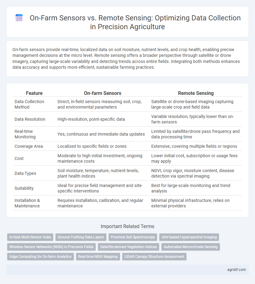
Table of Comparison
| Feature | On-farm Sensors | Remote Sensing |
|---|---|---|
| Data Collection Method | Direct, in-field sensors measuring soil, crop, and environmental parameters | Satellite or drone-based imaging capturing large-scale crop and field data |
| Data Resolution | High-resolution, point-specific data | Variable resolution, typically lower than on-farm sensors |
| Real-time Monitoring | Yes, continuous and immediate data updates | Limited by satellite/drone pass frequency and data processing time |
| Coverage Area | Localized to specific fields or zones | Extensive, covering multiple fields or regions |
| Cost | Moderate to high initial investment, ongoing maintenance costs | Lower initial cost, subscription or usage fees may apply |
| Data Types | Soil moisture, temperature, nutrient levels, plant health indices | NDVI, crop vigor, moisture content, disease detection via spectral imaging |
| Suitability | Ideal for precise field management and site-specific interventions | Best for large-scale monitoring and trend analysis |
| Installation & Maintenance | Requires installation, calibration, and regular maintenance | Minimal physical infrastructure, relies on external providers |
Introduction to Data Collection in Precision Agriculture
On-farm sensors provide real-time, localized data on soil moisture, nutrient levels, and crop health, enabling precise field management and immediate decision-making. Remote sensing utilizes satellite or drone imagery to capture large-scale spatial data, offering broad coverage and temporal monitoring essential for identifying trends and stress patterns across extensive farms. Combining both technologies enhances data accuracy and resolution, supporting optimized resource use and improved crop yields in precision agriculture.
Overview of On-farm Sensors
On-farm sensors provide real-time, site-specific data by directly measuring soil moisture, nutrient levels, crop health, and microclimatic conditions within the field. These sensors enable precise monitoring and immediate adjustments to irrigation, fertilization, and pest control, enhancing resource efficiency and crop yields. Integration with IoT and wireless networks facilitates continuous data collection and automated decision-making in precision agriculture.
Understanding Remote Sensing Technologies
Remote sensing technologies in precision agriculture utilize satellite imagery and drone-mounted multispectral cameras to capture high-resolution data on crop health, soil moisture, and pest infestations across vast farmland quickly and efficiently. These tools enable real-time monitoring and analysis, leveraging spectral bands such as near-infrared to detect plant stress invisible to the naked eye, improving decision-making accuracy. Advanced remote sensing integrates with geographic information systems (GIS) to create detailed maps that optimize input application, enhancing yield and resource management.
Key Parameters Measured by On-farm Sensors
On-farm sensors measure key parameters such as soil moisture, temperature, nutrient levels, and crop health indicators directly within the field, enabling real-time, site-specific data collection. These sensors provide high-resolution spatial and temporal insights critical for precision irrigation, fertilization, and pest management. Unlike remote sensing, on-farm sensors capture subsurface conditions and microclimate variations essential for optimizing crop yield and resource efficiency.
Data Types Obtained from Remote Sensing
Remote sensing in precision agriculture provides multispectral and hyperspectral data, capturing detailed information on crop health, soil moisture, and nutrient levels. It offers large-scale spatial coverage through satellite and drone imagery, enabling monitoring of vegetation indices, thermal patterns, and chlorophyll content. These data types support timely decision-making for irrigation, fertilization, and pest management with enhanced accuracy and efficiency.
Accuracy and Resolution: On-farm vs Remote Sensing
On-farm sensors deliver high-accuracy, real-time data with fine spatial resolution, capturing microvariations crucial for precise crop management. Remote sensing offers broader coverage and frequent temporal data but often with lower resolution, potentially missing detailed field-specific variability. Combining both technologies enhances overall data quality by balancing detailed local insights with extensive area monitoring for optimized decision-making.
Cost Considerations and ROI Comparison
On-farm sensors typically require higher initial investments for installation and maintenance but offer precise, real-time data that can significantly improve crop management efficiency. Remote sensing technologies, such as satellite and drone imaging, usually have lower upfront costs and cover larger areas quickly but may lack the granularity needed for detailed analysis. Evaluating ROI involves balancing the precision and immediacy of on-farm sensors against the broader, cost-effective coverage of remote sensing, with optimal strategies often integrating both for comprehensive data-driven decision-making.
Integration of On-farm and Remote Sensing Data
Integration of on-farm sensors and remote sensing data enhances precision agriculture by providing comprehensive real-time insights into crop health, soil conditions, and environmental factors. Combining high-resolution data from soil moisture probes and nutrient sensors with satellite or drone imagery enables more accurate spatial variability analysis and optimized resource management. This fusion supports precise decision-making, improving yield prediction and reducing input waste through targeted interventions.
Challenges and Limitations
On-farm sensors face challenges such as high installation costs, limited coverage area, and sensor maintenance requirements, restricting their scalability and spatial data accuracy. Remote sensing offers broader spatial coverage but struggles with issues like cloud cover interference, lower temporal resolution, and difficulties in capturing subsurface soil properties. Both methods require integration with advanced data analytics to overcome inherent limitations and provide reliable, real-time decision-making tools for precision agriculture.
Future Trends in Agricultural Data Collection
On-farm sensors deliver real-time, high-resolution data on soil moisture, nutrient levels, and crop health, enabling precise management decisions at the micro-plot level. Remote sensing technologies, including drones and satellite imagery, provide large-scale spatial data for monitoring crop growth patterns, pest infestations, and weather impacts efficiently over extensive farmland. Future trends emphasize the integration of both sensor types with AI-powered analytics and Internet of Things (IoT) networks to enhance predictive accuracy and facilitate automated, data-driven farming practices.
Related Important Terms
In-field Multi-Sensor Hubs
In-field multi-sensor hubs integrate diverse on-farm sensors such as soil moisture probes, nutrient detectors, and microclimate monitors to provide real-time, high-resolution data critical for precision agriculture management. These hubs enhance decision-making by enabling localized monitoring and automated adjustments, surpassing the spatial and temporal limitations commonly associated with remote sensing technologies.
Ground-Truthing Data Layers
On-farm sensors provide precise, real-time ground-truthing data by directly measuring soil moisture, temperature, and crop health at specific locations, ensuring high-resolution accuracy for data layers. Remote sensing complements this by offering broader spatial coverage through satellite or drone imagery, allowing validation and calibration of sensor data for comprehensive precision agriculture decision-making.
Proximal Soil Spectroscopy
Proximal soil spectroscopy in on-farm sensors offers real-time, high-resolution soil data by directly measuring spectral reflectance at the field level, enabling precise nutrient and moisture management. Remote sensing provides broader spatial coverage but may lack the granular accuracy of proximal methods essential for accurate soil property assessment and site-specific farming decisions.
UAV-based Hyperspectral Imaging
UAV-based hyperspectral imaging offers high-resolution, real-time data collection, enabling precise monitoring of crop health, soil variability, and nutrient levels directly in the field. Compared to traditional on-farm sensors, this remote sensing technology provides comprehensive spectral information across multiple wavelengths, enhancing decision-making accuracy for precision agriculture.
Wireless Sensor Networks (WSN) in Precision Fields
Wireless Sensor Networks (WSN) in precision agriculture enable real-time, high-resolution data collection directly from on-farm sensors, monitoring soil moisture, temperature, and crop health with minimal latency. These networks outperform remote sensing in providing localized, continuous data essential for precise irrigation management and disease detection, enhancing crop yield and resource efficiency.
Satellite-derived Vegetation Indices
Satellite-derived vegetation indices such as NDVI and EVI provide large-scale, consistent, and timely data for monitoring crop health and biomass in precision agriculture, enabling efficient resource allocation and yield prediction. On-farm sensors complement this by offering high-resolution, ground-truth data on soil moisture, nutrient levels, and microclimate conditions, essential for site-specific management decisions.
Automated Microclimate Sensing
Automated microclimate sensing through on-farm sensors delivers high-resolution, real-time data on temperature, humidity, and soil moisture directly within crop fields, enabling precise, localized decision-making for irrigation and pest management. Remote sensing complements this by providing broader spatial coverage and multispectral imaging, but often lacks the granular, immediate microclimate insights necessary for adaptive, site-specific interventions in precision agriculture.
Edge Computing for On-farm Analytics
On-farm sensors enable real-time data collection and processing through edge computing, providing immediate analytics for precision agriculture decisions without latency. Edge computing reduces dependence on cloud connectivity by locally analyzing sensor data, enhancing responsiveness and operational efficiency in crop management.
Real-time NDVI Mapping
On-farm sensors enable real-time NDVI mapping by providing continuous, high-resolution data directly from crop canopies, improving precision in managing plant health. Remote sensing offers broader spatial coverage but often with lower temporal resolution, making on-farm sensors more effective for timely decision-making in precision agriculture.
LIDAR Canopy Structure Assessment
On-farm LIDAR sensors provide high-resolution, real-time canopy structure data crucial for precision agriculture, enabling accurate measurement of plant height, density, and biomass. Remote sensing using airborne or satellite LIDAR offers broader spatial coverage but with lower temporal resolution and potential atmospheric interference impacting data accuracy for crop monitoring.
On-farm Sensors vs Remote Sensing for Data Collection Infographic