Autonomous drones offer precise field surveying with real-time data collection and lower operational costs compared to manned aerial vehicles. These drones enhance accuracy by capturing high-resolution imagery and multispectral data, enabling targeted crop management and early pest detection. Manned aerial vehicles provide longer flight times and larger coverage areas, but lack the flexibility and rapid deployment capabilities of autonomous systems in precision agriculture.
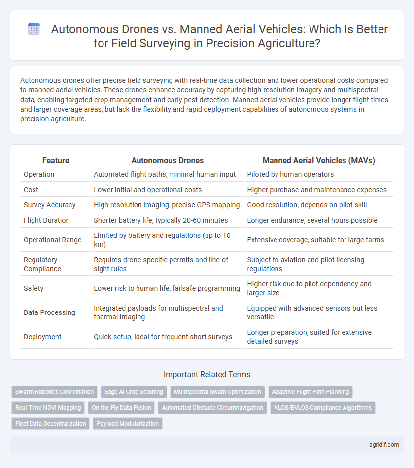
Table of Comparison
| Feature | Autonomous Drones | Manned Aerial Vehicles (MAVs) |
|---|---|---|
| Operation | Automated flight paths, minimal human input | Piloted by human operators |
| Cost | Lower initial and operational costs | Higher purchase and maintenance expenses |
| Survey Accuracy | High-resolution imaging, precise GPS mapping | Good resolution, depends on pilot skill |
| Flight Duration | Shorter battery life, typically 20-60 minutes | Longer endurance, several hours possible |
| Operational Range | Limited by battery and regulations (up to 10 km) | Extensive coverage, suitable for large farms |
| Regulatory Compliance | Requires drone-specific permits and line-of-sight rules | Subject to aviation and pilot licensing regulations |
| Safety | Lower risk to human life, failsafe programming | Higher risk due to pilot dependency and larger size |
| Data Processing | Integrated payloads for multispectral and thermal imaging | Equipped with advanced sensors but less versatile |
| Deployment | Quick setup, ideal for frequent short surveys | Longer preparation, suited for extensive detailed surveys |
Introduction to Aerial Surveying in Precision Agriculture
Autonomous drones in precision agriculture offer high-resolution imaging and real-time data collection for efficient field surveying, enabling precise monitoring of crop health and soil conditions. Manned aerial vehicles (MAVs) provide broader coverage and longer flight durations but at higher operational costs and limited repeatability compared to drones. The integration of multispectral sensors and GPS technology in these aerial platforms significantly enhances data accuracy, supporting informed decision-making in modern agricultural management.
Overview of Autonomous Drones in Field Surveying
Autonomous drones in precision agriculture revolutionize field surveying by providing high-resolution imaging and real-time data collection with minimal human intervention. Equipped with multispectral and thermal sensors, these drones enable accurate crop health assessment, soil analysis, and pest detection, enhancing decision-making efficiency. Their ability to perform frequent, repeatable flights ensures comprehensive monitoring and early identification of field variations, improving overall yield management.
Manned Aerial Vehicles: Traditional Approaches in Crop Monitoring
Manned aerial vehicles (MAVs) have long been utilized in precision agriculture for crop monitoring, providing extensive aerial imagery and multispectral data to assess field health. These traditional aircraft enable large-scale, high-resolution surveys essential for detecting pest infestations, nutrient deficiencies, and irrigation issues. Despite higher operational costs and limited flight frequency compared to autonomous drones, MAVs offer reliable performance in diverse weather conditions and extensive coverage for comprehensive field analysis.
Data Accuracy and Imaging Capabilities
Autonomous drones in precision agriculture deliver superior data accuracy through advanced GPS systems and real-time sensor integration, enabling precise field mapping and crop health monitoring. Their high-resolution multispectral and hyperspectral imaging capabilities surpass manned aerial vehicles, providing detailed insights into plant stress, soil conditions, and pest infestations. Manned aerial vehicles offer broader coverage but lack the granularity and frequent data collection efficiency critical for optimizing agricultural yields and resource management.
Operational Efficiency and Coverage Area
Autonomous drones in precision agriculture offer superior operational efficiency by enabling rapid, repeatable flights with minimal human intervention, reducing labor costs and downtime. They can cover smaller fields with high-resolution data and execute complex flight patterns for targeted monitoring, whereas manned aerial vehicles excel in surveying larger acreage but involve higher operational expenses and logistical coordination. The choice between these technologies hinges on balancing the scale of coverage with the need for detailed, frequent data acquisition to optimize crop management.
Cost Comparison: Investment and Maintenance
Autonomous drones require a lower initial investment, typically ranging from $1,000 to $20,000, compared to manned aerial vehicles that can cost upwards of $100,000 to several million dollars. Maintenance expenses for drones are significantly reduced due to fewer mechanical components and simplified operational needs, whereas manned aircraft incur higher costs for fuel, pilot training, regulatory compliance, and regular servicing. The reduced financial burden of autonomous drones enables more frequent and scalable field surveys, driving better cost-efficiency in precision agriculture.
Safety, Accessibility, and Regulation Compliance
Autonomous drones offer enhanced safety by eliminating pilot risk during low-altitude field surveys, while manned aerial vehicles require experienced pilots and pose higher operational hazards. Drones provide greater accessibility in navigating tight agricultural zones and real-time data collection, whereas manned aircraft are limited by runway availability and weather constraints. Regulatory frameworks increasingly favor autonomous drones for precision agriculture due to streamlined compliance processes and lower certification barriers compared to manned aerial vehicles.
Real-Time Data Processing and Integration
Autonomous drones equipped with advanced sensors enable real-time data processing and immediate integration into precision agriculture systems, enhancing the speed and accuracy of field surveys. Manned aerial vehicles often rely on post-flight data analysis, resulting in delays that can impact timely decision-making for crop management. Real-time integration from autonomous drones supports dynamic adjustments in irrigation, fertilization, and pest control, optimizing resource use and boosting crop yield efficiency.
Environmental Impact and Sustainability
Autonomous drones reduce carbon emissions by consuming less fuel compared to manned aerial vehicles, supporting sustainable field surveying practices. Their ability to conduct frequent, precise monitoring enables optimized resource usage, minimizing environmental footprint. Manned aerial vehicles typically require larger fuel loads and emit more greenhouse gases, making drones a more eco-friendly solution for precision agriculture.
Future Trends: AI and the Evolution of Aerial Surveying
Autonomous drones equipped with AI-powered sensors and machine learning algorithms enable precise, real-time crop health monitoring and soil analysis, surpassing manned aerial vehicles in efficiency and data accuracy. The integration of advanced computer vision and predictive analytics is driving a shift towards fully automated aerial surveying systems that reduce human intervention and operational costs. Future trends indicate widespread adoption of swarm drone technology and AI-driven flight optimization, transforming precision agriculture with rapid, scalable, and highly detailed field assessments.
Related Important Terms
Swarm Robotics Coordination
Autonomous drones employing swarm robotics coordination enable real-time, high-resolution crop monitoring by simultaneously covering larger field areas with synchronized flight paths, significantly enhancing data collection efficiency compared to manned aerial vehicles. This technology reduces human error and operational costs while providing granular insights through integrated multi-sensor platforms for precision agriculture applications.
Edge AI Crop Scouting
Autonomous drones equipped with Edge AI crop scouting technology enable real-time data processing and precise disease detection directly in the field, significantly reducing latency compared to manned aerial vehicles which rely on post-flight data analysis. This integration enhances the accuracy of crop health monitoring and allows for immediate decision making, optimizing resource use and improving yield predictions in precision agriculture.
Multispectral Swath Optimization
Autonomous drones equipped with advanced multispectral sensors offer precise swath optimization by autonomously adapting flight paths to maximize field coverage and data resolution, significantly reducing overlap and gaps in imagery. Manned aerial vehicles, while capable of broader range coverage, lack the real-time adaptive control needed for multispectral swath optimization, often resulting in less efficient data collection and higher operational costs.
Adaptive Flight Path Planning
Autonomous drones utilize advanced sensors and AI-driven algorithms for adaptive flight path planning, enabling precise, real-time adjustments to optimize field coverage and data accuracy. Manned aerial vehicles rely on pilot expertise and pre-determined routes, which can limit flexibility and precision in dynamic agricultural environments.
Real-Time NDVI Mapping
Autonomous drones equipped with advanced multispectral sensors provide high-resolution real-time NDVI mapping, enabling precise monitoring of crop health and timely decision-making in precision agriculture. Manned aerial vehicles offer broader coverage but lack the immediate data processing capabilities and cost-efficiency of drone-based surveys for rapid vegetative index analysis.
On-the-Fly Data Fusion
Autonomous drones leverage real-time on-the-fly data fusion by integrating multispectral, LiDAR, and RGB sensor inputs to generate precise, high-resolution field maps for precision agriculture. Manned aerial vehicles, while capable of carrying sophisticated sensors, often face delays in data processing and less granularity due to manual operation constraints and fixed flight paths.
Automated Obstacle Circumnavigation
Autonomous drones equipped with real-time LiDAR and computer vision systems achieve precise automated obstacle circumnavigation in field surveying, reducing human error and operational risk compared to manned aerial vehicles. These drones enable continuous data collection over uneven terrain, enhancing crop monitoring efficiency and accuracy through adaptive flight paths without pilot intervention.
VLOS/EVLOS Compliance Algorithms
Autonomous drones equipped with VLOS/EVLOS compliance algorithms enable precise and efficient field surveying by maintaining visual contact and ensuring regulatory adherence, significantly reducing pilot workload compared to manned aerial vehicles. These algorithms optimize flight paths and obstacle avoidance, enhancing data accuracy and operational safety in precision agriculture applications.
Fleet Data Decentralization
Autonomous drones enable real-time fleet data decentralization through edge computing, minimizing latency and enhancing field surveying accuracy across large agricultural areas. In contrast, manned aerial vehicles rely on centralized data processing, which can delay decision-making and reduce responsiveness in precision agriculture applications.
Payload Modularization
Autonomous drones equipped with modular payload systems allow rapid interchange of sensors such as multispectral cameras, LiDAR, and thermal imaging for precise field surveying, enhancing data collection efficiency and customization. Manned aerial vehicles typically offer larger payload capacities but lack the flexibility and quick adaptability of drones' modular payloads, limiting on-the-fly sensor upgrades and targeted data acquisition.
Autonomous Drones vs Manned Aerial Vehicles for Field Surveying Infographic