Yield mapping and yield monitoring are crucial components in precision agriculture that enhance crop performance analysis by providing detailed spatial data. Yield monitoring involves real-time measurement of crop yield using sensors during harvest, while yield mapping processes this data to create visual maps representing yield variability across fields. Combining these technologies helps farmers identify high- and low-performing zones, enabling targeted interventions that optimize input use and increase overall productivity.
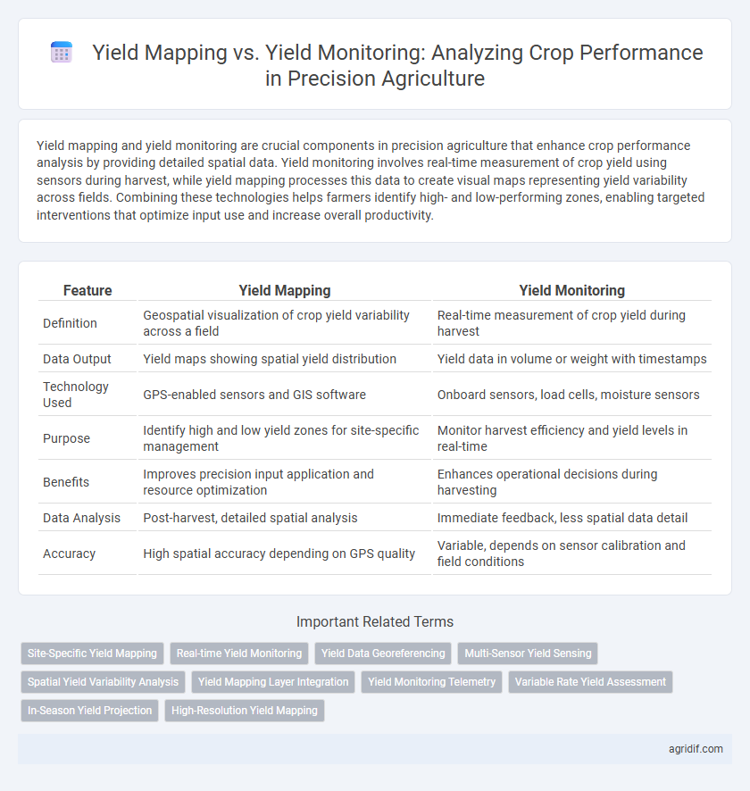
Table of Comparison
| Feature | Yield Mapping | Yield Monitoring |
|---|---|---|
| Definition | Geospatial visualization of crop yield variability across a field | Real-time measurement of crop yield during harvest |
| Data Output | Yield maps showing spatial yield distribution | Yield data in volume or weight with timestamps |
| Technology Used | GPS-enabled sensors and GIS software | Onboard sensors, load cells, moisture sensors |
| Purpose | Identify high and low yield zones for site-specific management | Monitor harvest efficiency and yield levels in real-time |
| Benefits | Improves precision input application and resource optimization | Enhances operational decisions during harvesting |
| Data Analysis | Post-harvest, detailed spatial analysis | Immediate feedback, less spatial data detail |
| Accuracy | High spatial accuracy depending on GPS quality | Variable, depends on sensor calibration and field conditions |
Understanding Yield Mapping and Yield Monitoring
Yield mapping involves creating spatial representations of crop yield data collected during harvest, utilizing GPS technology to identify variations in productivity across different field zones. Yield monitoring captures real-time data on crop output using sensors mounted on harvesting equipment, providing continuous measurement of yield, moisture, and other parameters as crops are collected. Understanding the distinction between yield mapping and yield monitoring enables farmers to analyze crop performance more accurately, optimize input use, and improve overall farm management strategies.
Key Differences Between Yield Mapping and Yield Monitoring
Yield mapping provides a spatial visualization of crop yield variability across a field by integrating GPS data with yield measurements, enabling farmers to identify high and low productivity zones for targeted management. Yield monitoring collects real-time data on crop yield during harvest through sensors on combines but lacks the detailed spatial analysis offered by yield mapping. The key difference lies in yield mapping's ability to transform raw yield data into actionable field-specific insights, while yield monitoring focuses solely on collecting harvest data without geospatial context.
Technologies Involved in Yield Data Collection
Yield mapping employs GPS-enabled combines equipped with grain flow sensors to capture spatially referenced harvest data, enabling precise field variability analysis. Yield monitoring utilizes load cells and moisture sensors on harvesting equipment to continuously record crop yield and quality metrics in real time. Both technologies integrate data acquisition systems and software platforms to process and visualize yield information, enhancing decision-making in precision agriculture.
Data Accuracy: Yield Mapping vs Yield Monitoring
Yield mapping provides spatially detailed data by integrating GPS coordinates with yield measurements, enabling farmers to identify variability within fields and make targeted management decisions. Yield monitoring captures real-time overall crop yield data during harvest, focusing on aggregate metrics rather than precise spatial distribution. Data accuracy in yield mapping surpasses yield monitoring by offering granular, geo-referenced insights critical for optimizing crop performance and input application.
Role in Crop Performance Analysis
Yield mapping provides spatially detailed data by creating GPS-based maps of crop yield variability across fields, enabling farmers to identify high and low productivity zones for targeted management. Yield monitoring collects real-time data during harvest, offering immediate insights on crop performance and equipment efficiency without spatial context. Together, these tools enhance crop performance analysis by combining precise location-specific yield information with temporal harvest data for optimized decision-making in precision agriculture.
Spatial Variability Assessment in Precision Agriculture
Yield mapping captures detailed spatial variability by creating georeferenced maps of crop yield across different field zones, enabling precise analysis of performance and identification of high- and low-yield areas. Yield monitoring collects real-time data on crop output during harvest, providing continuous yield measurements but without the spatial resolution offered by mapping. Integrating yield mapping with yield monitoring enhances spatial variability assessment, supporting informed management decisions for optimizing input use and improving crop productivity in precision agriculture.
Integrating Yield Data with Farm Management Software
Yield mapping provides spatial visualization of crop performance by recording yield data across different field zones, enabling more precise input application and resource allocation. Yield monitoring collects real-time data during harvest, capturing crop yield and moisture content to assess overall productivity. Integrating yield data with farm management software enhances decision-making by combining historical yield maps with other agronomic data layers, facilitating targeted interventions and optimizing crop management strategies.
Practical Applications for Farmers
Yield mapping provides farmers with detailed spatial data on crop yield variability across fields, enabling targeted interventions such as variable-rate fertilization and irrigation. Yield monitoring collects real-time data from harvesting equipment to assess overall crop performance and detect anomalies during harvest. Combining both tools enhances decision-making, optimizes input usage, and ultimately increases farm productivity and profitability.
Advantages and Limitations of Each Approach
Yield mapping offers precise spatial visualization of crop performance by integrating GPS data with yield monitor measurements, enabling targeted field management and identification of variability patterns. Yield monitoring provides real-time data on crop output during harvest, facilitating immediate decision-making but lacks detailed spatial resolution compared to yield mapping. While yield mapping enhances long-term analysis and variable-rate application strategies, its complexity and higher costs limit accessibility, whereas yield monitoring's simplicity benefits quick assessments but may not fully capture field heterogeneity.
Future Trends in Yield Analysis Technologies
Yield mapping integrates GPS data with yield measurements to create detailed spatial representations of crop performance, enabling precise field-level management. Yield monitoring collects real-time data during harvest, focusing on immediate operational decisions and equipment efficiency. Future trends emphasize enhanced sensor fusion, AI-driven analytics, and drone-based remote sensing to improve accuracy and predictive capabilities in yield analysis technologies.
Related Important Terms
Site-Specific Yield Mapping
Site-specific yield mapping provides detailed geospatial data that highlights variations in crop performance within different field zones, enabling precise adjustments in management practices. Yield monitoring collects overall harvest data but lacks the spatial resolution essential for identifying micro-environmental factors affecting productivity in precision agriculture.
Real-time Yield Monitoring
Real-time yield monitoring provides immediate data on crop performance by continuously measuring harvest output with GPS-linked sensors, enabling precise spatial analysis and timely decision-making during the harvesting process. Yield mapping aggregates this data into detailed visual representations, facilitating retrospective performance analysis and strategic planning for future crop management.
Yield Data Georeferencing
Yield mapping integrates GPS technology with yield monitoring to create spatially referenced maps that display crop performance variability across fields, enabling precise analysis of yield data georeferencing. Yield monitoring collects raw harvest data but lacks geospatial context, limiting the ability to correlate yield outcomes with specific field locations for targeted decision-making.
Multi-Sensor Yield Sensing
Yield mapping integrates spatial data and multi-sensor yield sensing technology to create detailed georeferenced maps of crop performance, enhancing precision agriculture decisions by pinpointing yield variability across fields. Yield monitoring employs real-time data collection from multi-sensor systems during harvest to measure crop output, providing immediate insights but with less spatial resolution compared to yield mapping.
Spatial Yield Variability Analysis
Yield mapping captures spatial yield variability by creating georeferenced maps that highlight performance differences across a field, enabling precise identification of high- and low-yield zones. Yield monitoring continuously collects real-time data during harvest, providing detailed information on crop output variability, critical for analyzing spatial yield patterns and optimizing field management.
Yield Mapping Layer Integration
Yield mapping integrates spatial data layers such as soil type, moisture levels, and nutrient distribution to create detailed maps that enable precise analysis of crop yield variations across a field, enhancing decision-making for variable-rate applications. Yield monitoring captures real-time data during harvesting but lacks the layered spatial context of yield mapping, making the integration of additional geospatial information critical for comprehensive crop performance evaluation in precision agriculture.
Yield Monitoring Telemetry
Yield Monitoring telemetry provides real-time data collection on crop performance by using sensors and GPS technology to record yield variations across a field, enabling precise decision-making during the harvesting process. This continuous data stream enhances detailed spatial analysis compared to traditional Yield Mapping, which typically involves post-harvest data aggregation and lacks immediate telemetry feedback.
Variable Rate Yield Assessment
Yield mapping provides spatially detailed data showing variability within fields, enabling precise variable rate yield assessment for optimized input application. Yield monitoring captures real-time harvesting data to analyze overall crop performance but lacks the granular spatial resolution necessary for targeted agronomic decisions.
In-Season Yield Projection
Yield mapping provides spatially detailed data on actual crop performance by capturing yield variability across fields, essential for analyzing patterns and informing management decisions. Yield monitoring, equipped with real-time sensors, enables in-season yield projection by continuously collecting data during harvest, facilitating timely adjustments in precision agriculture strategies to optimize crop outcomes.
High-Resolution Yield Mapping
High-resolution yield mapping provides detailed spatial data that enhances crop performance analysis by identifying field variability and pinpointing areas of high and low productivity for precision management. Compared to yield monitoring, which collects general yield data during harvesting, high-resolution yield mapping enables more accurate decision-making through finer granularity in data collection and interpretation.
Yield Mapping vs Yield Monitoring for crop performance analysis Infographic