RTK GPS provides centimeter-level accuracy for field positioning, making it indispensable for precision agriculture where exact plant spacing and resource application are crucial. Standard GPS, while sufficient for general navigation, offers meter-level accuracy that can lead to inefficiencies in planting and input usage. The enhanced precision of RTK GPS significantly improves crop yields and reduces waste by enabling precise control of agricultural machinery across large fields.
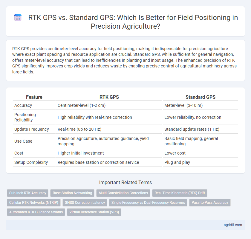
Table of Comparison
| Feature | RTK GPS | Standard GPS |
|---|---|---|
| Accuracy | Centimeter-level (1-2 cm) | Meter-level (3-10 m) |
| Positioning Reliability | High reliability with real-time correction | Lower reliability, no correction |
| Update Frequency | Real-time (up to 20 Hz) | Standard update rates (1 Hz) |
| Use Case | Precision agriculture, automated guidance, yield mapping | Basic field mapping, general positioning |
| Cost | Higher initial investment | Lower cost |
| Setup Complexity | Requires base station or correction service | Plug and play |
Introduction to Field Positioning Technologies in Precision Agriculture
RTK GPS delivers centimeter-level accuracy by utilizing real-time corrections from base stations, making it ideal for precise field positioning in precision agriculture. Standard GPS offers meter-level accuracy but lacks the precision needed for tasks like row guidance and variable-rate applications. Accurate positioning technologies like RTK GPS enhance crop management, resource efficiency, and yield optimization.
What is RTK GPS?
RTK GPS (Real-Time Kinematic Global Positioning System) provides centimeter-level accuracy by using a fixed base station to transmit correction signals to a mobile receiver in the field. This highly precise positioning technology enables farmers to optimize field operations such as planting, fertilizing, and harvesting with greater efficiency compared to standard GPS, which typically offers meter-level accuracy. RTK GPS enhances precision agriculture by reducing input waste, improving crop yields, and enabling automated machinery guidance.
What is Standard GPS?
Standard GPS relies on a network of satellites to provide location data with an accuracy typically within 3 to 10 meters, which is suitable for general navigation but lacks the precision required for detailed field positioning in agriculture. This system uses signals from multiple satellites to triangulate positions without any real-time error correction, leading to potential inaccuracies caused by atmospheric conditions or signal obstructions. In precision agriculture, while standard GPS aids in broad mapping, its positional errors limit effectiveness in tasks demanding centimeter-level accuracy, such as seed placement or variable rate application.
Accuracy Comparison: RTK GPS vs Standard GPS
RTK GPS offers centimeter-level accuracy in field positioning, significantly surpassing the meter-level precision of standard GPS systems, which is crucial for precise seed placement and variable rate applications. This enhanced accuracy reduces overlap and input waste, optimizing crop yields and resource use in precision agriculture. Farmers relying on RTK GPS can achieve real-time corrections that mitigate signal errors, ensuring consistent, high-precision guidance across diverse field conditions.
Equipment and Infrastructure Requirements
RTK GPS requires specialized base stations and rover units equipped with radio modems or cellular connectivity to provide real-time correction signals, whereas standard GPS operates solely with satellite signals and basic GPS receivers. The infrastructure for RTK includes a permanent or mobile base station strategically positioned within a 10-15 km radius to ensure centimeter-level accuracy, while standard GPS lacks this dependency and offers meter-level precision without extra equipment. Implementing RTK GPS entails higher initial costs due to advanced hardware and network setup, compared to standard GPS systems which rely on widely available, lower-cost receivers suitable for general field positioning.
Cost Analysis of RTK GPS and Standard GPS
RTK GPS systems, offering centimeter-level accuracy, involve higher initial investment and maintenance costs compared to Standard GPS devices that provide meter-level precision at a lower price point. While RTK GPS equipment may cost between $10,000 and $25,000, Standard GPS units generally range from $200 to $2,000, making affordability a critical factor for small-to-medium farm operations. The improved accuracy of RTK GPS can lead to enhanced crop yields and resource efficiency, potentially offsetting its higher cost through increased productivity and reduced input waste.
Application Scenarios in Precision Agriculture
RTK GPS offers centimeter-level accuracy, making it ideal for tasks such as soil sampling, planting, and variable rate application where precise field positioning is critical. Standard GPS, with accuracy around 2-5 meters, suits general field navigation and equipment guidance but may result in overlaps or gaps in crop treatment. Precision agriculture benefits significantly from RTK GPS in scenarios requiring high-resolution spatial data to optimize inputs, enhance yields, and reduce resource waste.
Benefits and Limitations of RTK GPS
RTK GPS offers centimeter-level accuracy in field positioning, significantly enhancing precision agriculture by enabling precise planting, fertilizing, and irrigation. Its benefits include real-time corrections, reduced input costs, and improved crop yields, while limitations involve higher equipment costs, dependency on a reliable correction signal, and limited coverage in remote areas. Standard GPS provides meter-level accuracy suitable for general navigation but lacks the precision needed for detailed agricultural tasks.
Benefits and Limitations of Standard GPS
Standard GPS offers widespread accessibility and cost-effectiveness for field positioning in precision agriculture, enabling basic navigation and mapping capabilities. However, its positional accuracy typically ranges between 3 to 10 meters, which limits the precision needed for tasks like variable-rate application and automated machinery guidance. The lack of real-time corrections and susceptibility to signal errors reduce overall efficiency compared to RTK GPS, which provides centimeter-level accuracy essential for advanced farm management.
Making the Right Choice for Your Farm
RTK GPS offers centimeter-level accuracy by using a fixed base station and real-time corrections, making it ideal for tasks requiring precise field positioning like planting and soil sampling. Standard GPS, with accuracy typically around 3-5 meters, suits general navigation and large-scale mapping but may lead to inefficiencies in input application and crop management. Farmers choosing between these systems should consider the scale of their operations, budget constraints, and the precision needed to optimize yield and reduce input costs.
Related Important Terms
Sub-Inch RTK Accuracy
RTK GPS technology provides sub-inch accuracy for field positioning by correcting satellite signal discrepancies in real time, significantly outperforming standard GPS systems that typically offer accuracy within 1 to 3 meters. This enhanced precision allows farmers to execute site-specific management practices, optimize input application, and improve crop yield efficiency in precision agriculture.
Base Station Networking
RTK GPS provides centimeter-level accuracy for field positioning by utilizing a network of base stations that transmit real-time correction signals, significantly surpassing the meter-level precision offered by standard GPS systems. Base station networking enhances positional reliability and reduces latency, enabling precise machinery guidance essential for optimizing crop management in precision agriculture.
Multi-Constellation Corrections
RTK GPS leverages multi-constellation corrections from systems like GPS, GLONASS, Galileo, and BeiDou, providing centimeter-level accuracy essential for precision agriculture field positioning. Standard GPS typically relies on a single constellation and offers meter-level accuracy, which may not meet the precise requirements for tasks such as variable rate application and automated machinery guidance.
Real-Time Kinematic (RTK) Drift
Real-Time Kinematic (RTK) GPS provides centimeter-level accuracy in field positioning by correcting satellite signal errors in real time, significantly reducing drift compared to standard GPS systems that can experience meter-level inaccuracies due to signal delays and atmospheric conditions. This enhanced precision from RTK is critical for applications like variable-rate input application and autonomous machinery, ensuring optimal resource use and improved crop yields.
Cellular RTK Networks (NTRIP)
Cellular RTK networks using NTRIP provide centimeter-level accuracy for field positioning, significantly outperforming standard GPS systems which typically offer meter-level precision. This enhanced accuracy supports precise planting, fertilizing, and harvesting operations in precision agriculture by enabling real-time kinematic corrections delivered via cellular connectivity.
GNSS Correction Latency
RTK GPS offers centimeter-level accuracy with GNSS correction latency typically under one second, enabling precise real-time field positioning critical for tasks like autonomous tractor navigation. Standard GPS, however, has higher latency and meter-level accuracy, making it less effective for precision agriculture applications requiring immediate and exact location data.
Single-Frequency vs Dual-Frequency Receivers
Dual-frequency RTK GPS receivers provide centimeter-level accuracy in field positioning by using both L1 and L2 signals to correct atmospheric errors, significantly outperforming single-frequency standard GPS receivers that rely solely on the L1 signal and typically offer meter-level accuracy. Enhanced precision from dual-frequency RTK GPS enables precise seed placement, optimized input application, and improved yield mapping in precision agriculture.
Pass-to-Pass Accuracy
RTK GPS offers centimeter-level pass-to-pass accuracy essential for precision agriculture, enabling precise seed planting and fertilizer application, while standard GPS typically provides accuracy within 1 to 3 meters, limiting field-level precision. Enhanced positioning precision with RTK GPS reduces overlaps and gaps in coverage, improving yield consistency and resource efficiency across agricultural fields.
Automated RTK Guidance Swaths
Automated RTK guidance swaths leverage RTK GPS's centimeter-level accuracy to precisely steer agricultural machinery, significantly reducing overlap and gaps compared to standard GPS with meter-level precision. This enhanced positioning improves field efficiency, minimizes input waste, and boosts crop yields by ensuring consistent coverage across the entire field.
Virtual Reference Station (VRS)
RTK GPS with Virtual Reference Station (VRS) technology offers centimeter-level accuracy in field positioning by utilizing a network of fixed base stations to provide real-time correction data, surpassing the meter-level precision of standard GPS. VRS enhances precision agriculture by enabling precise seeding, fertilization, and harvesting, resulting in optimized input use and increased crop yields.
RTK GPS vs Standard GPS for Field Positioning Infographic