Remote sensing technology in precision agriculture enables the collection of large-scale crop and soil data through satellite or drone imagery, offering valuable insights into field variability without physical contact. Proximal sensing involves sensors placed close to or within the crop canopy for real-time, high-resolution data on plant health, soil moisture, and nutrient status. Combining both methods enhances decision-making accuracy, optimizing resource use and crop yield efficiency.
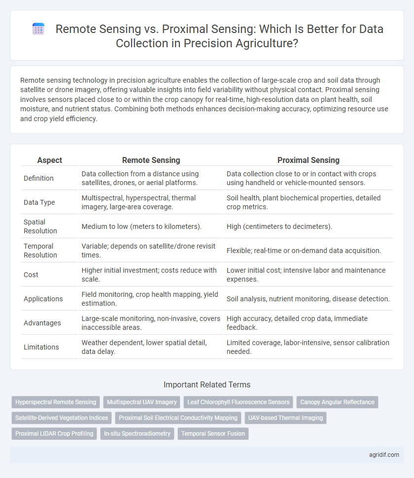
Table of Comparison
| Aspect | Remote Sensing | Proximal Sensing |
|---|---|---|
| Definition | Data collection from a distance using satellites, drones, or aerial platforms. | Data collection close to or in contact with crops using handheld or vehicle-mounted sensors. |
| Data Type | Multispectral, hyperspectral, thermal imagery, large-area coverage. | Soil health, plant biochemical properties, detailed crop metrics. |
| Spatial Resolution | Medium to low (meters to kilometers). | High (centimeters to decimeters). |
| Temporal Resolution | Variable; depends on satellite/drone revisit times. | Flexible; real-time or on-demand data acquisition. |
| Cost | Higher initial investment; costs reduce with scale. | Lower initial cost; intensive labor and maintenance expenses. |
| Applications | Field monitoring, crop health mapping, yield estimation. | Soil analysis, nutrient monitoring, disease detection. |
| Advantages | Large-scale monitoring, non-invasive, covers inaccessible areas. | High accuracy, detailed crop data, immediate feedback. |
| Limitations | Weather dependent, lower spatial detail, data delay. | Limited coverage, labor-intensive, sensor calibration needed. |
Introduction to Precision Agriculture Data Collection
Remote sensing employs satellite or drone imagery to capture extensive crop data, enabling monitoring of large agricultural fields with high temporal frequency. Proximal sensing utilizes ground-based sensors positioned near crops to provide precise, localized measurements of soil conditions, moisture levels, and plant health. Integrating both remote and proximal sensing technologies enhances the accuracy and detail of precision agriculture data collection, supporting informed decision-making for optimized crop management.
Defining Remote Sensing in Agriculture
Remote sensing in agriculture involves capturing data from satellites, drones, or aircraft to monitor crop health, soil conditions, and moisture levels over large areas. This technology utilizes multispectral and hyperspectral imaging to analyze vegetation indices, enabling precise assessment of plant growth and stress factors. Remote sensing provides scalable, non-intrusive data collection crucial for optimizing irrigation, fertilization, and yield prediction.
Understanding Proximal Sensing Technologies
Proximal sensing technologies in precision agriculture involve collecting data from sensors positioned close to crops or soil, providing high-resolution and accurate information on plant health and soil conditions. These sensors include tools such as handheld spectrometers, soil probes, and drones flying low for detailed monitoring, enabling timely interventions to optimize yield. Compared to remote sensing, proximal sensing offers more precise spatial variability analysis within fields, enhancing decision-making for irrigation, fertilization, and pest control.
Key Technologies in Remote Sensing
Remote sensing relies on key technologies such as multispectral and hyperspectral imaging, LiDAR, and satellite-based sensors to capture extensive crop and soil data from a distance. These technologies enable precise monitoring of plant health, soil moisture, and nutrient content across large agricultural areas, facilitating data-driven decisions. Compared to proximal sensing, which involves close-range devices like spectral sensors or soil probes, remote sensing offers broader coverage and real-time insights essential for optimizing crop yields.
Proximal Sensing Hardware and Applications
Proximal sensing in precision agriculture utilizes hardware such as handheld spectrometers, soil probes, and on-vehicle sensors to collect high-resolution data directly from crops and soil surfaces. These devices enable real-time monitoring of nutrient levels, moisture content, and plant health, facilitating precise input applications and improving crop management efficiency. Proximal sensing hardware supports variable rate technology (VRT) by providing accurate spatial data essential for site-specific interventions in precision farming.
Data Resolution: Remote vs Proximal Sensing
Remote sensing provides large-scale crop and soil data with moderate resolution, capturing multispectral and satellite imagery crucial for monitoring vast agricultural fields. Proximal sensing offers higher data resolution through close-range devices like handheld sensors or drones, enabling detailed measurements of plant health and soil conditions at the micro-level. The integration of remote and proximal sensing enhances precision agriculture by combining broad spatial coverage with fine-scale accuracy in data collection.
Cost and Accessibility Comparison
Remote sensing utilizes satellite and aerial imagery to collect large-scale agricultural data at higher initial costs, making it less accessible for small-scale farmers but ideal for expansive crop monitoring. Proximal sensing employs ground-based sensors and handheld devices, offering more affordable, real-time data collection suitable for localized farm management. The cost-effectiveness and ease of access of proximal sensing technologies enable widespread adoption in precision agriculture, while remote sensing provides comprehensive spatial data for strategic decision-making.
Integration with Farm Management Systems
Remote sensing technologies leverage satellite and drone imagery to provide large-scale, real-time data on crop health and soil conditions, which seamlessly integrate with farm management systems (FMS) for comprehensive field analysis and decision making. Proximal sensing uses ground-based sensors for high-resolution, localized data collection, enhancing precision by feeding detailed environmental and crop metrics directly into FMS platforms. Combining both remote and proximal sensing creates a synergistic data ecosystem that optimizes input application, improves yield forecasting, and supports sustainable agricultural practices within precision agriculture frameworks.
Use Cases: Crop Monitoring and Disease Detection
Remote sensing utilizes satellite or drone imagery to monitor large-scale crop health and detect disease outbreaks through multispectral data analysis, enabling early intervention. Proximal sensing employs ground-based sensors, such as handheld spectrometers or soil probes, for high-resolution, localized detection of nutrient deficiencies and pathogen presence within specific crop zones. Integrating both remote and proximal sensing technologies enhances precision agriculture by providing comprehensive data for targeted crop monitoring and timely disease management.
Future Trends in Sensing for Precision Agriculture
Remote sensing technologies, including satellite and drone-based imaging, are increasingly favored for large-scale precision agriculture due to their ability to monitor vast crop areas with multispectral and hyperspectral sensors. Proximal sensing methods, such as soil moisture probes and plant canopy sensors, provide high-resolution, real-time data critical for site-specific management and immediate decision-making. Future trends emphasize the integration of AI-driven analytics, edge computing, and IoT networks to fuse remote and proximal sensing data, enhancing predictive capabilities and sustainable resource use in smart farming systems.
Related Important Terms
Hyperspectral Remote Sensing
Hyperspectral remote sensing captures detailed spectral information across numerous narrow bands, enabling precise detection of crop health, nutrient status, and stress factors over large agricultural areas without physical contact. In contrast to proximal sensing, hyperspectral remote sensing provides comprehensive, high-resolution data crucial for informed decision-making and optimizing resource management in precision agriculture.
Multispectral UAV Imagery
Multispectral UAV imagery offers high-resolution remote sensing data critical for precision agriculture, enabling detailed crop health analysis and timely decision-making across large fields. Compared to proximal sensing, UAV-based multispectral imaging covers broader areas rapidly while providing multispectral data layers essential for detecting plant stress, nutrient deficiencies, and disease symptoms.
Leaf Chlorophyll Fluorescence Sensors
Leaf Chlorophyll Fluorescence Sensors in precision agriculture enable detailed monitoring of plant photosynthetic activity by capturing real-time data on chlorophyll fluorescence, with remote sensing offering large-scale canopy-level insights while proximal sensing provides high-resolution, plant-specific measurements. This combination enhances crop health assessment, stress detection, and yield prediction by integrating broad spatial coverage and precise localized data.
Canopy Angular Reflectance
Canopy angular reflectance in precision agriculture is crucial for assessing crop health, with remote sensing capturing canopy reflectance from satellite or aerial platforms at multiple angles, providing large-scale spatial variability data. In contrast, proximal sensing uses ground-based sensors to measure reflectance at finer angular resolutions, enabling detailed monitoring of canopy structure and stress conditions at the plot level.
Satellite-Derived Vegetation Indices
Satellite-derived vegetation indices such as NDVI and EVI enable large-scale monitoring of crop health and stress in precision agriculture by delivering high-resolution, multispectral data from remote sensing platforms. While proximal sensing offers detailed, ground-level measurements, satellite remote sensing provides continuous, scalable coverage critical for detecting spatial variability and optimizing resource management across extensive agricultural fields.
Proximal Soil Electrical Conductivity Mapping
Proximal Soil Electrical Conductivity (EC) Mapping offers high-resolution, site-specific soil data by directly measuring soil properties such as texture, moisture, and salinity with sensors positioned near the ground surface. Compared to remote sensing, proximal EC mapping enables more accurate detection of soil variability, enhancing precision agriculture practices through optimized nutrient management and irrigation scheduling.
UAV-based Thermal Imaging
UAV-based thermal imaging in precision agriculture offers high-resolution remote sensing data critical for monitoring crop health, soil moisture, and plant stress with greater spatial accuracy than traditional proximal sensing methods. This technology enables efficient detection of temperature variations across large fields, optimizing irrigation scheduling and enhancing yield predictions through non-invasive and timely data collection.
Proximal LIDAR Crop Profiling
Proximal LIDAR crop profiling in precision agriculture offers high-resolution, three-dimensional plant structure data by capturing detailed canopy height and density metrics, enabling accurate biomass estimation and growth monitoring. Compared to remote sensing, proximal LIDAR provides real-time, localized insights crucial for precise crop management and variable rate applications.
In-situ Spectroradiometry
In-situ spectroradiometry, a key proximal sensing technique, provides high-resolution spectral data directly from crop canopies, enabling precise assessment of plant health and nutrient status. Compared to remote sensing, this method reduces atmospheric interference and allows for real-time calibration, enhancing the accuracy of vegetation indices used in precision agriculture.
Temporal Sensor Fusion
Remote sensing leverages satellite or aerial imagery capturing large-scale temporal changes, while proximal sensing uses ground-based sensors for detailed, high-frequency data collection, enabling precise temporal sensor fusion by integrating both scales for enhanced crop monitoring. Combining temporal data from these sources improves accuracy in detecting plant health trends and optimizing resource management in precision agriculture.
Remote Sensing vs Proximal Sensing for data collection Infographic