Satellite imagery provides extensive coverage and regular updates, enabling large-scale monitoring of crop health and soil conditions with valuable spectral data. Drone imagery offers higher resolution and flexibility, allowing precise identification of pest infestations, nutrient deficiencies, and irrigation issues in specific field zones. Combining both technologies enhances precision agriculture by delivering comprehensive and detailed insights for efficient field scouting and management.
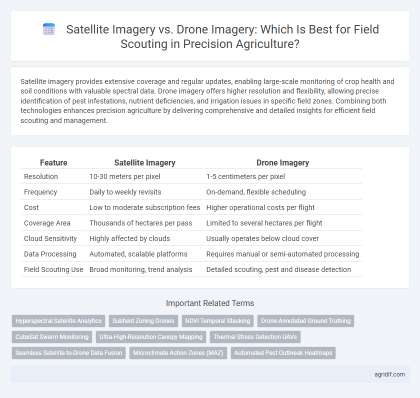
Table of Comparison
| Feature | Satellite Imagery | Drone Imagery |
|---|---|---|
| Resolution | 10-30 meters per pixel | 1-5 centimeters per pixel |
| Frequency | Daily to weekly revisits | On-demand, flexible scheduling |
| Cost | Low to moderate subscription fees | Higher operational costs per flight |
| Coverage Area | Thousands of hectares per pass | Limited to several hectares per flight |
| Cloud Sensitivity | Highly affected by clouds | Usually operates below cloud cover |
| Data Processing | Automated, scalable platforms | Requires manual or semi-automated processing |
| Field Scouting Use | Broad monitoring, trend analysis | Detailed scouting, pest and disease detection |
Overview of Satellite and Drone Imagery in Precision Agriculture
Satellite imagery in precision agriculture offers extensive field coverage with frequent revisit times and multispectral data essential for monitoring crop health and soil conditions across large areas. Drone imagery provides high-resolution, customizable views that enable detailed scouting, precise plant-level analysis, and rapid response to crop stress or pest detection. Combining satellite and drone data enhances decision-making through multiscale insights, optimizing yield and resource management in modern farming practices.
Key Differences Between Satellite and Drone Imagery
Satellite imagery covers extensive agricultural areas with high revisit frequency, offering consistent data for large-scale crop monitoring. Drone imagery provides ultra-high-resolution images and real-time assessments, enabling precise detection of crop stress, pest infestations, and irrigation issues at a micro-level. Key differences include spatial resolution, temporal frequency, and operational flexibility, with drones excelling in detailed field scouting and satellites in broad, repetitive coverage.
Spatial Resolution: Satellite vs Drone Capabilities
Satellite imagery offers broad coverage with spatial resolutions typically ranging from 10 to 30 meters per pixel, suitable for monitoring large-scale crop health patterns. Drone imagery provides significantly higher spatial resolution, often below 5 centimeters per pixel, enabling detailed analysis of individual plants and early detection of stress factors. This granular level of detail makes drones ideal for precision field scouting, while satellites are more efficient for regional agricultural assessments.
Temporal Frequency: Image Update Rates for Field Scouting
Satellite imagery provides regular image updates with revisit times ranging from daily to weekly, enabling consistent monitoring of large agricultural areas. Drone imagery offers on-demand, high-frequency captures allowing for real-time assessments tailored to specific field conditions. The higher temporal resolution of drone data supports rapid detection of changes in crop health, while satellite images supply broader temporal coverage essential for long-term trend analysis.
Coverage Area: Large Farms vs Targeted Plots
Satellite imagery offers extensive coverage ideal for monitoring large farm expanses, providing consistent data across thousands of acres in a single pass. Drone imagery excels in delivering high-resolution, targeted views of specific plots within these farms, enabling precise scouting and detailed crop health assessment. Balancing satellite data for broad trends with drone data for localized insights enhances decision-making accuracy in precision agriculture.
Cost Considerations and ROI Analysis
Satellite imagery offers broader coverage at a lower initial cost per acre, making it cost-effective for large-scale field scouting in precision agriculture. Drone imagery, while more expensive upfront due to equipment and operational costs, provides higher resolution data enabling precise crop health monitoring and targeted interventions that can enhance yield and reduce input costs. ROI analysis shows drones deliver superior economic benefits for smaller, high-value fields through detailed data, whereas satellites optimize budget efficiency for expansive agricultural operations.
Weather and Cloud Cover Limitations
Satellite imagery in precision agriculture offers extensive coverage but is significantly hindered by weather conditions and cloud cover, often resulting in delays or obscured field data during critical scouting periods. Drone imagery provides more timely and flexible data acquisition by operating below cloud layers, enabling detailed and frequent monitoring unaffected by typical atmospheric interference. Farmers benefit from integrating both technologies, using satellite imagery for broad overviews and drone imagery for targeted, weather-resilient field scouting.
Data Integration and Software Compatibility
Satellite imagery offers broad, high-frequency coverage ideal for integrating with GIS platforms and large-scale data analytics software, enhancing real-time decision-making in precision agriculture. Drone imagery provides ultra-high-resolution data that complements satellite data by enabling detailed crop health assessments and targeted interventions through compatible image processing tools. Both sources require seamless integration with farm management systems to optimize field scouting, leveraging APIs and cloud-based software for synchronized data analysis and actionable insights.
Use Cases: When to Choose Satellite or Drone Imagery
Satellite imagery offers extensive coverage and regular revisit intervals, making it ideal for monitoring large-scale crop health, identifying regional stress patterns, and assessing overall field conditions. Drone imagery provides high-resolution, targeted data perfect for detailed crop scouting, pest detection, and precise intervention in smaller or problem-specific areas. Choosing between satellite and drone imagery depends on field size, required detail, and frequency of data updates needed for effective decision-making in precision agriculture.
Future Trends in Agricultural Remote Sensing Technologies
Emerging trends in agricultural remote sensing underscore enhanced resolution and real-time data processing through a hybrid approach combining satellite and drone imagery for precision agriculture. Advances in satellite technology, such as higher revisit rates and improved spectral sensors, complement drone capabilities in capturing ultra-high-resolution, localized crop data, enabling more accurate field scouting and stress detection. Integration of AI-driven analytics and cloud-based platforms is accelerating the future of crop monitoring by providing actionable insights, optimizing resource use, and boosting overall farm productivity.
Related Important Terms
Hyperspectral Satellite Analytics
Hyperspectral satellite analytics in precision agriculture enhances field scouting by capturing detailed spectral signatures over large areas, enabling early detection of crop stress and nutrient deficiencies. Compared to drone imagery, satellite hyperspectral data offers broader coverage with frequent revisit times, supporting timely and scalable crop health monitoring.
Subfield Zoning Drones
Drone imagery offers higher-resolution data and real-time monitoring capabilities essential for precise subfield zoning in precision agriculture, enabling targeted interventions that enhance crop yield and resource efficiency. Satellite imagery provides broader coverage and historical data trends but lacks the granularity needed for detailed subfield analysis and immediate problem detection.
NDVI Temporal Stacking
Satellite imagery provides extensive coverage and frequent revisit times ideal for NDVI temporal stacking, enabling consistent monitoring of crop health over large agricultural areas. Drone imagery offers higher spatial resolution, capturing detailed NDVI variations within fields, which enhances precision in identifying stress zones and optimizing field scouting efforts.
Drone-Annotated Ground Truthing
Drone-annotated ground truthing offers high-resolution, real-time data critical for validating satellite imagery in precision agriculture, enhancing crop health assessments and yield predictions. Integrating drone imagery with satellite data improves accuracy in monitoring field variability, enabling targeted interventions and optimizing resource use.
CubeSat Swarm Monitoring
CubeSat Swarm Monitoring offers high-frequency, large-scale satellite imagery with consistent multispectral data, enabling precise crop health analysis and stress detection over extensive agricultural fields. Compared to drone imagery, CubeSats provide broader coverage and continuous monitoring, enhancing field scouting efficiency and decision-making in precision agriculture.
Ultra-High-Resolution Canopy Mapping
Drone imagery provides ultra-high-resolution canopy mapping surpassing satellite imagery with spatial resolutions often below 5 cm per pixel, enabling precise detection of crop health variations and pest infestations. While satellite imagery covers extensive areas with frequent revisit times, drones deliver detailed data crucial for targeted field scouting and optimizing agricultural inputs.
Thermal Stress Detection UAVs
Satellite imagery offers wide-area coverage with moderate thermal resolution, suitable for large-scale thermal stress detection, while UAVs equipped with advanced thermal sensors provide high-resolution, real-time data critical for pinpointing localized crop stress. UAV thermal imagery enables more precise monitoring of plant water stress and heat patterns, enhancing decision-making in precision agriculture by facilitating targeted irrigation and timely interventions.
Seamless Satellite-to-Drone Data Fusion
Seamless satellite-to-drone data fusion enhances precision agriculture by integrating high-resolution, real-time drone imagery with broad-coverage satellite data, enabling comprehensive field scouting and improved crop health monitoring. This approach combines satellite multispectral images for large-scale analysis with drone-derived detailed views, optimizing decision-making and resource allocation in precision farming.
Microclimate Action Zones (MAZ)
Satellite imagery provides extensive spatial coverage and temporal frequency ideal for identifying large-scale Microclimate Action Zones (MAZ), while drone imagery offers high-resolution data crucial for detailed analysis of MAZ variations within individual fields. Combining satellite data with drone-based observations enhances the precision of microclimate monitoring, enabling targeted interventions and optimized resource management in precision agriculture.
Automated Pest Outbreak Heatmaps
Satellite imagery provides broad coverage and frequent updates ideal for detecting large-scale pest outbreaks, while drone imagery offers higher resolution and real-time data crucial for precise automated pest outbreak heatmaps and targeted intervention in precision agriculture. Combining satellite data with drone-based thermal and multispectral sensors enhances accuracy in mapping pest hotspots, optimizing crop protection strategies and minimizing pesticide use.
Satellite Imagery vs Drone Imagery for Field Scouting Infographic