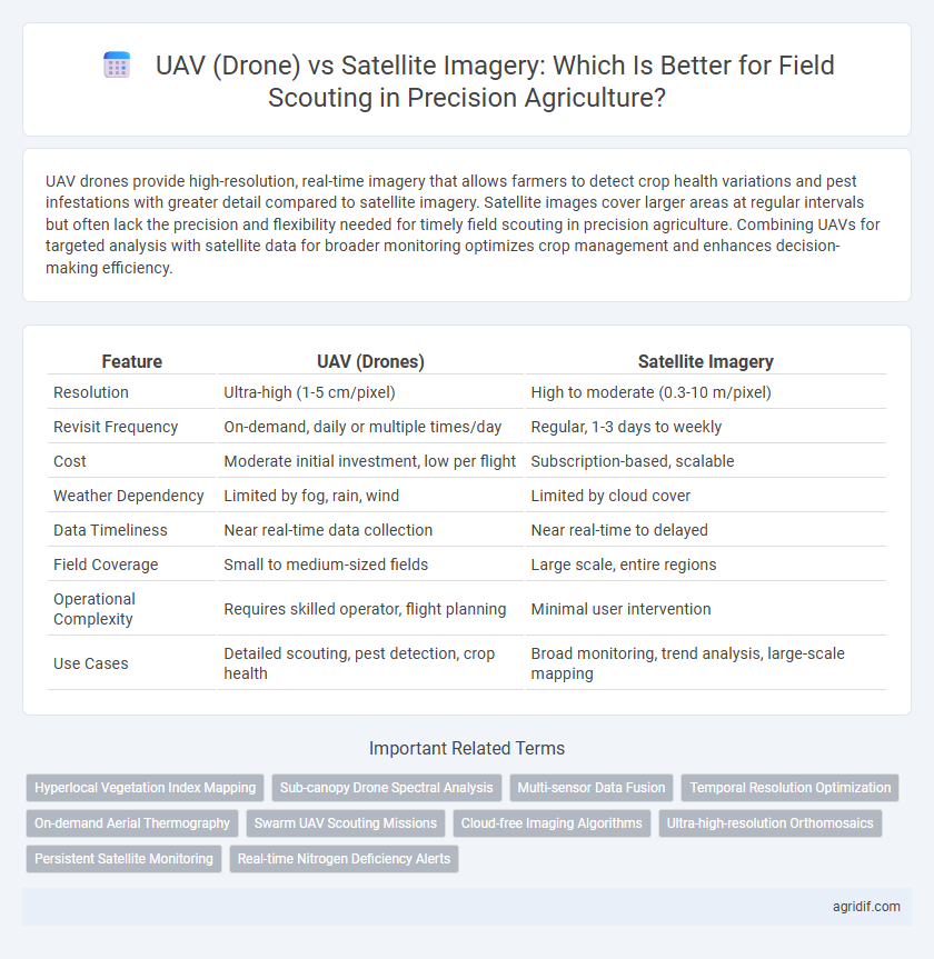
UAV drones provide high-resolution, real-time imagery that allows farmers to detect crop health variations and pest infestations with greater detail compared to satellite imagery. Satellite images cover larger areas at regular intervals but often lack the precision and flexibility needed for timely field scouting in precision agriculture. Combining UAVs for targeted analysis with satellite data for broader monitoring optimizes crop management and enhances decision-making efficiency.
Table of Comparison
| Feature | UAV (Drones) | Satellite Imagery |
|---|---|---|
| Resolution | Ultra-high (1-5 cm/pixel) | High to moderate (0.3-10 m/pixel) |
| Revisit Frequency | On-demand, daily or multiple times/day | Regular, 1-3 days to weekly |
| Cost | Moderate initial investment, low per flight | Subscription-based, scalable |
| Weather Dependency | Limited by fog, rain, wind | Limited by cloud cover |
| Data Timeliness | Near real-time data collection | Near real-time to delayed |
| Field Coverage | Small to medium-sized fields | Large scale, entire regions |
| Operational Complexity | Requires skilled operator, flight planning | Minimal user intervention |
| Use Cases | Detailed scouting, pest detection, crop health | Broad monitoring, trend analysis, large-scale mapping |
Overview of UAV and Satellite Imagery in Precision Agriculture
UAVs (drones) provide high-resolution, real-time imagery with flexible flight scheduling, enabling precise monitoring of crop health, pest infestations, and nutrient deficiencies at the field level. Satellite imagery covers larger areas with multispectral and hyperspectral data, offering valuable insights into crop conditions and environmental factors but often at lower spatial resolution and limited revisit frequency. Integrating UAV and satellite data enhances precision agriculture by combining detailed, localized observations with broad, temporal crop trend analysis.
Resolution and Data Quality: UAVs vs Satellites
UAVs offer superior spatial resolution, often capturing images with centimeter-level detail, enabling precise identification of crop stress and pest infestations in real-time. Satellite imagery typically provides meter-level resolution, which may miss fine-scale variability but covers larger areas more efficiently. The high-resolution data from UAVs enhances field scouting accuracy and supports targeted interventions, whereas satellites deliver broader temporal coverage and multispectral data critical for long-term crop monitoring.
Cost-Effectiveness Comparison
UAVs (drones) offer higher-resolution, real-time data for precision agriculture field scouting, enabling targeted interventions but require upfront investment and operational costs such as maintenance and skilled piloting. Satellite imagery provides broader coverage at a lower per-acre cost, suitable for large-scale monitoring but may suffer from lower spatial resolution and weather-dependent delays. Cost-effectiveness depends on farm size and data needs; drones favor small to medium operations demanding detailed insights, while satellites benefit extensive fields requiring frequent, less detailed observations.
Timeliness and Data Acquisition Frequency
UAVs (drones) offer superior timeliness and higher data acquisition frequency compared to satellite imagery, enabling real-time monitoring and rapid response to crop conditions in precision agriculture. Satellite data, while providing broader coverage, often suffers from lower revisit rates and delays due to weather and orbital constraints. Frequent UAV flights allow for detailed, up-to-date field scouting, optimizing decision-making and resource management.
Scalability and Coverage Area
UAVs (drones) offer high-resolution, localized data ideal for detailed crop monitoring but face scalability limitations due to limited flight time and battery capacity. Satellite imagery provides extensive coverage over vast agricultural landscapes, enabling large-scale field scouting with frequent revisit times, though typically at lower spatial resolution. Combining UAVs for targeted analysis and satellites for broad area surveillance enhances precision agriculture by balancing coverage area with detailed data acquisition.
Weather Dependency and Operational Limitations
UAVs (drones) provide high-resolution, real-time data for precision agriculture but are highly weather-dependent, with performance affected by rain, wind, and low visibility. Satellite imagery offers consistent coverage regardless of weather, though cloud cover can impede data quality and revisit frequencies limit temporal resolution. Operational constraints for UAVs include limited flight duration and regulatory restrictions, whereas satellites cover larger areas but with lower spatial precision.
Integration with Farm Management Systems
UAVs (drones) offer high-resolution, real-time data ideal for detailed crop health monitoring, while satellite imagery provides broad, frequent coverage suitable for large-scale field analysis. Integration of UAV data with Farm Management Systems (FMS) allows precise, site-specific intervention plans, enhancing yield prediction and resource allocation. Satellite imagery combined with FMS supports strategic decision-making through trend analysis and long-term crop performance tracking.
Use Cases: Best Scenarios for UAVs and Satellites
UAVs excel in precision agriculture by providing high-resolution, real-time imagery ideal for detailed crop health monitoring, pest detection, and localized irrigation management. Satellite imagery covers large areas efficiently, offering valuable data for regional crop performance analysis, weather impact assessment, and long-term trend monitoring. Combining UAVs and satellites enhances field scouting by leveraging UAVs' accuracy for spot-checks and satellites' broad coverage for macro-level decision-making.
Regulatory and Privacy Considerations
UAVs (drones) enable precise, low-altitude monitoring with greater regulatory restrictions varying by country, often requiring pilot certification, flight permissions, and compliance with no-fly zones to ensure safety and privacy. Satellite imagery offers broad coverage and fewer regulatory hurdles, but lower resolution and potential privacy concerns arise from capturing images over private lands without explicit consent. Balancing UAV flexibility with strict regulations against satellite imagery's wide accessibility is crucial for responsible field scouting in precision agriculture.
Future Trends in Remote Sensing for Field Scouting
UAVs (drones) provide ultra-high-resolution, real-time data with customizable flight paths that enable precise monitoring of crop health and early pest detection, enhancing decision-making in precision agriculture. Satellite imagery continues to improve with higher temporal frequency and advanced multispectral sensors, offering extensive coverage and cost-effective field scouting for large-scale farms. Future trends indicate the integration of UAV and satellite data through AI-driven analytics, improving accuracy and enabling predictive modeling for optimized crop management and sustainable agricultural practices.
Related Important Terms
Hyperlocal Vegetation Index Mapping
UAVs provide high-resolution, hyperlocal vegetation index mapping essential for precision agriculture by capturing detailed crop health data at the plant level, enabling targeted interventions. Satellite imagery offers broader coverage but lacks the spatial resolution and temporal flexibility of drones, limiting its effectiveness for real-time, localized field scouting and precise vegetation analysis.
Sub-canopy Drone Spectral Analysis
UAVs equipped with advanced spectral sensors offer superior sub-canopy drone spectral analysis compared to satellite imagery by capturing high-resolution, multispectral data beneath crop canopies for precise field scouting. This capability enables real-time detection of plant health issues, pest infestations, and nutrient deficiencies at a granular level, outperforming satellites limited by canopy obstruction and lower spatial resolution.
Multi-sensor Data Fusion
Multi-sensor data fusion combining UAV drones and satellite imagery enhances precision agriculture by integrating high-resolution, real-time aerial data with broad spatial coverage for comprehensive field scouting. This fusion improves crop health monitoring, stress detection, and decision-making accuracy by leveraging the complementary strengths of both platforms.
Temporal Resolution Optimization
UAVs provide superior temporal resolution for field scouting in precision agriculture by enabling frequent, on-demand data collection tailored to specific crop monitoring needs. Satellites, while useful for broader area coverage, often have lower revisit rates impacted by orbital schedules and weather conditions, limiting timely intervention opportunities.
On-demand Aerial Thermography
UAVs provide high-resolution, on-demand aerial thermography for precision agriculture, enabling real-time field scouting with detailed temperature variations critical for early stress detection and irrigation management. Satellite imagery offers broader coverage but lacks the spatial and temporal resolution necessary for timely, targeted interventions in crop health monitoring.
Swarm UAV Scouting Missions
Swarm UAV scouting missions provide real-time, high-resolution field data with precise geolocation, enabling targeted crop health monitoring and pest detection that surpasses the lower spatial resolution and delayed updates of satellite imagery. Coordinated drone swarms enhance efficiency by covering large agricultural areas quickly while adapting to variable field conditions, offering superior flexibility and actionable insights for precision agriculture management.
Cloud-free Imaging Algorithms
UAVs provide high-resolution, cloud-free imaging through real-time data capture and advanced onboard sensors, enabling precise field scouting even in localized weather conditions. Satellite imagery relies on cloud-free imaging algorithms like cloud masking and interpolation, but often suffers from delays and lower spatial resolution compared to the immediate and detailed data UAVs deliver.
Ultra-high-resolution Orthomosaics
UAVs equipped with multispectral sensors capture ultra-high-resolution orthomosaics at centimeter-level detail, enabling precise crop health monitoring and targeted interventions, whereas satellite imagery offers broader coverage but at lower spatial resolution, often limited to meters per pixel. The enhanced spatial accuracy from drones supports detailed field scouting, early stress detection, and variable rate application, making UAVs a superior choice for precision agriculture requiring fine-scale data.
Persistent Satellite Monitoring
Persistent satellite monitoring offers continuous, large-scale field scouting with high revisit frequencies and multispectral data, enabling timely detection of crop stress and nutrient deficiencies across extensive agricultural landscapes. UAVs provide ultra-high resolution and targeted data collection but are limited by flight duration and coverage area, making satellites more efficient for ongoing, comprehensive crop monitoring in precision agriculture.
Real-time Nitrogen Deficiency Alerts
UAVs equipped with multispectral sensors provide high-resolution, real-time nitrogen deficiency alerts by capturing detailed crop health data at low altitudes, enabling targeted precision agriculture interventions. Satellite imagery offers broader field coverage but lacks the temporal resolution and immediacy required for timely nitrogen stress detection during critical growth stages.
UAV (Drones) vs Satellite Imagery for field scouting Infographic