Yield mapping provides detailed, field-specific data by recording actual crop output during harvest, enabling precise identification of high and low productivity zones. Yield estimation leverages remote sensing and predictive models before harvest to forecast potential yields, supporting proactive resource allocation and timely decision-making. Combining these approaches enhances harvest planning accuracy, optimizing input use and maximizing overall crop performance.
Table of Comparison
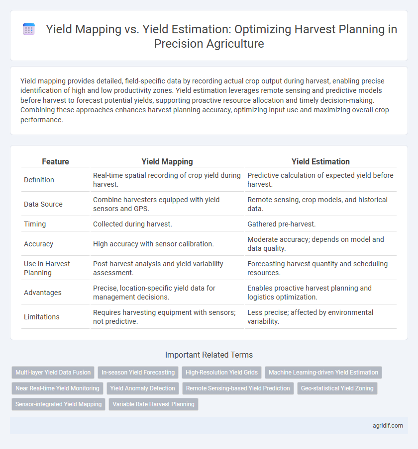
| Feature | Yield Mapping | Yield Estimation |
|---|---|---|
| Definition | Real-time spatial recording of crop yield during harvest. | Predictive calculation of expected yield before harvest. |
| Data Source | Combine harvesters equipped with yield sensors and GPS. | Remote sensing, crop models, and historical data. |
| Timing | Collected during harvest. | Gathered pre-harvest. |
| Accuracy | High accuracy with sensor calibration. | Moderate accuracy; depends on model and data quality. |
| Use in Harvest Planning | Post-harvest analysis and yield variability assessment. | Forecasting harvest quantity and scheduling resources. |
| Advantages | Precise, location-specific yield data for management decisions. | Enables proactive harvest planning and logistics optimization. |
| Limitations | Requires harvesting equipment with sensors; not predictive. | Less precise; affected by environmental variability. |
Introduction to Yield Mapping and Yield Estimation
Yield mapping involves collecting spatial data on crop yield variations across a field using GPS-enabled combines, providing precise information for site-specific management. Yield estimation utilizes remote sensing, crop models, and historical data to predict total harvest volume before actual harvesting. Integrating yield mapping and estimation enhances accuracy in harvest planning and resource allocation.
Importance of Accurate Harvest Planning
Accurate harvest planning relies heavily on precise yield mapping and yield estimation to optimize resource allocation and crop management strategies. Yield mapping provides detailed spatial data on crop performance across a field, enabling targeted interventions and improving overall productivity. Yield estimation complements this by forecasting expected output, aiding in logistics, storage preparation, and market timing to maximize profitability.
What is Yield Mapping in Precision Agriculture?
Yield mapping in precision agriculture involves collecting and analyzing georeferenced data on crop yields using GPS-equipped harvesters and yield monitors. This technology creates detailed spatial maps that highlight variations in productivity across different field zones, enabling farmers to identify high- and low-yield areas with accuracy. Yield mapping supports informed decision-making for site-specific management practices to optimize resource use and improve overall farm profitability.
Understanding Yield Estimation Techniques
Yield estimation techniques in precision agriculture utilize data from remote sensing, machine learning models, and crop growth simulations to predict potential harvest quantities with high accuracy. Yield mapping, in contrast, involves collecting spatially referenced data during harvest to create detailed maps that reflect actual crop output variations across fields. Understanding yield estimation methods enables farmers to anticipate yields before harvest, facilitating optimized resource allocation and improved harvest planning strategies.
Key Differences Between Yield Mapping and Yield Estimation
Yield mapping involves collecting spatially detailed data during harvest using combine sensors to create precise yield distribution maps, while yield estimation predicts potential crop output before harvest based on variables like plant growth, weather, and soil conditions. Yield mapping provides real-time, historical yield data for site-specific management decisions, whereas yield estimation supports proactive planning and resource allocation prior to harvesting. The key difference lies in yield mapping's reliance on actual harvest data contrasted with yield estimation's predictive modeling approach for harvest planning.
Technologies Enabling Yield Mapping
Yield mapping in precision agriculture relies on advanced GPS technology combined with yield monitors equipped on harvesting machinery to capture real-time data on crop output and field variability. Sensors including optical, moisture, and yield sensors integrate with GPS systems to generate accurate yield maps, facilitating spatial analysis for optimizing harvest planning. These technological tools enable farmers to manage field-specific inputs, improve decision-making, and enhance overall productivity through precise yield measurement rather than estimation.
Methods Used for Yield Estimation
Yield estimation in precision agriculture commonly employs remote sensing techniques, including multispectral and hyperspectral imaging, to assess crop health and predict harvest outcomes. Machine learning algorithms analyze data from UAVs and satellites to generate accurate yield predictions by correlating vegetation indices with historical yield data. Combining soil sensors and meteorological data further refines yield estimation models, enabling precise harvest planning and resource allocation.
Advantages and Limitations of Yield Mapping
Yield mapping provides precise, field-level data on crop yield variability by leveraging GPS and combine harvester sensors, enabling detailed spatial analysis for targeted interventions. Its advantages include improved decision-making for variable rate applications and enhanced understanding of within-field productivity patterns. Limitations involve high equipment costs, data processing complexity, and potential inaccuracies due to sensor calibration and field conditions variability.
Comparing Yield Estimation and Yield Mapping for Decision-Making
Yield mapping provides detailed spatial data on crop production variability across fields, enabling precise management practices and targeted interventions. Yield estimation offers timely approximations of overall crop output, crucial for resource allocation and logistic planning during harvest. Comparing both, yield mapping excels in field-specific decision-making while yield estimation supports broader harvest strategy and market forecasting.
Future Trends in Harvest Planning with Precision Agriculture
Yield mapping utilizes real-time sensor data to create detailed spatial representations of crop output, enabling precise field-level management. Yield estimation leverages predictive analytics and remote sensing technologies to forecast harvest volumes before actual reaping, optimizing resource allocation and logistics. Future trends in harvest planning emphasize integration of AI-driven models, drone-based monitoring, and IoT connectivity to enhance accuracy, scalability, and decision-making efficiency in precision agriculture.
Related Important Terms
Multi-layer Yield Data Fusion
Multi-layer yield data fusion enhances harvest planning by integrating spatially precise yield mapping with predictive yield estimation models, enabling more accurate and dynamic crop performance analysis. This approach leverages real-time sensor data, satellite imagery, and historical yield trends to optimize resource allocation and improve decision-making in precision agriculture.
In-season Yield Forecasting
In-season yield forecasting leverages real-time sensor data and historical crop performance to provide accurate yield estimates crucial for harvest planning, while yield mapping records spatial yield variability post-harvest for field analysis. Advanced yield estimation models enable proactive decision-making, optimizing resource allocation and improving overall crop management efficiency.
High-Resolution Yield Grids
High-resolution yield grids enhance harvest planning by providing precise spatial yield data through yield mapping, enabling targeted interventions and resource allocation. Yield estimation offers broader predictive insights but lacks the granular accuracy necessary for optimizing field-level decisions in precision agriculture.
Machine Learning-driven Yield Estimation
Machine learning-driven yield estimation leverages satellite imagery, sensor data, and historical yield records to provide real-time, high-resolution predictions, enabling more accurate and timely harvest planning compared to traditional yield mapping techniques that rely on post-harvest data collection. This predictive approach enhances resource allocation, reduces waste, and improves overall farm management efficiency in precision agriculture.
Near Real-time Yield Monitoring
Near real-time yield monitoring in precision agriculture enhances harvest planning by providing accurate, spatially detailed yield mapping directly from combine sensors, enabling farmers to identify field variability and optimize resource allocation. Yield estimation models complement this by predicting overall crop output based on remote sensing and historical data, supporting decision-making when immediate sensor data is unavailable or incomplete.
Yield Anomaly Detection
Yield mapping leverages GPS and sensor data to create detailed spatial representations of crop yield variability, enabling precise identification of yield anomalies across a field. Yield estimation uses predictive models based on historical and real-time data to forecast harvest output, but yield mapping provides superior resolution for detecting localized yield anomalies critical for targeted intervention.
Remote Sensing-based Yield Prediction
Remote sensing-based yield prediction leverages satellite imagery and drone data to generate high-resolution yield maps that capture spatial variability across fields, enabling more accurate harvest planning compared to traditional yield estimation methods relying on historical averages or manual sampling. Yield mapping provides granular, real-time field data that improves decision-making by identifying low- and high-yield zones, optimizing resource allocation, and reducing harvest losses in precision agriculture.
Geo-statistical Yield Zoning
Geo-statistical yield zoning in precision agriculture enhances harvest planning by using spatial analysis of yield mapping data to identify field variability and optimize resource allocation. Yield estimation complements this process by providing predictive insights, but detailed yield maps enable more accurate zoning for tailored management practices.
Sensor-integrated Yield Mapping
Sensor-integrated yield mapping leverages GPS and real-time data collection from combine harvesters to create detailed spatial yield variability maps, enabling precise analysis of crop performance across different field zones. Accurate yield estimation models, while useful for forecasting overall harvest volume, lack the granularity and responsiveness of sensor-driven yield maps crucial for optimizing harvest logistics and field management decisions.
Variable Rate Harvest Planning
Yield mapping provides real-time, spatially accurate data on crop performance across fields, enabling precise identification of high and low yield zones essential for variable rate harvest planning. Yield estimation leverages predictive models and historical data to forecast overall output, supporting resource allocation but lacking the granular field variability captured by yield mapping.
Yield Mapping vs Yield Estimation for Harvest Planning Infographic