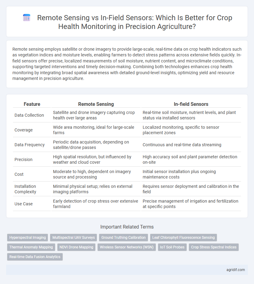
Remote sensing employs satellite or drone imagery to provide large-scale, real-time data on crop health indicators such as vegetation indices and moisture levels, enabling farmers to detect stress patterns across extensive fields quickly. In-field sensors offer precise, localized measurements of soil moisture, nutrient content, and microclimate conditions, supporting targeted interventions and timely decision-making. Combining both technologies enhances crop health monitoring by integrating broad spatial awareness with detailed ground-level insights, optimizing yield and resource management in precision agriculture.
Table of Comparison
| Feature | Remote Sensing | In-field Sensors |
|---|---|---|
| Data Collection | Satellite and drone imagery capturing crop health over large areas | Real-time soil moisture, nutrient levels, and plant status via installed sensors |
| Coverage | Wide area monitoring, ideal for large-scale farms | Localized monitoring, specific to sensor placement zones |
| Data Frequency | Periodic data acquisition, depending on satellite/drone passes | Continuous and real-time data streaming |
| Precision | High spatial resolution, but influenced by weather and cloud cover | High accuracy soil and plant parameter detection on-site |
| Cost | Moderate to high, dependent on imagery source and processing | Initial sensor installation plus ongoing maintenance costs |
| Installation Complexity | Minimal physical setup; relies on external imaging platforms | Requires sensor deployment and calibration in the field |
| Use Case | Early detection of crop stress over extensive farmland | Precise management of irrigation and fertilization at specific points |
Introduction to Crop Health Monitoring Technologies
Remote sensing technologies utilize satellite or drone imagery to capture large-scale crop health data by detecting variations in plant reflectance and temperature, enabling timely identification of stress factors such as nutrient deficiencies or pest infestations. In-field sensors, including soil moisture probes and leaf chlorophyll meters, provide real-time, site-specific measurements that allow farmers to make precise management decisions based on localized crop conditions. Combining remote sensing with in-field sensors enhances the accuracy and efficiency of crop health monitoring systems in precision agriculture.
Overview of Remote Sensing in Precision Agriculture
Remote sensing in precision agriculture utilizes satellite imagery, drones, and aerial sensors to capture large-scale crop health data, enabling the detection of stress, nutrient deficiencies, and pest infestations from above. These technologies provide multispectral and hyperspectral images that analyze plant reflectance patterns, offering critical insights into crop vigor, soil conditions, and water status across vast agricultural fields. Remote sensing complements in-field sensors by delivering comprehensive spatial coverage and timely data for optimized decision-making in crop management.
Understanding In-field Sensors for Crop Monitoring
In-field sensors provide real-time, localized data crucial for precise crop health monitoring by measuring soil moisture, nutrient levels, and plant stress indicators directly within the field environment. These sensors enable targeted interventions, enhancing resource efficiency and crop yield while minimizing environmental impact. Their integration with IoT platforms supports continuous data collection and advanced analytics, facilitating proactive decision-making in precision agriculture.
Data Collection Methods: Remote vs In-field Approaches
Remote sensing utilizes satellite or drone-based imagery to capture large-scale crop health data, enabling analysis of vegetation indices and spatial variability over extensive areas. In-field sensors, including soil moisture probes and leaf chlorophyll meters, provide real-time, localized measurements that offer high-resolution insights into plant physiology and microclimate conditions. Combining these data collection methods enhances precision in monitoring crop health by integrating broad landscape patterns with detailed ground-level information.
Spatial and Temporal Resolution: A Comparative Analysis
Remote sensing offers extensive spatial coverage with satellite and drone imaging providing multi-spectral data for crop health at field and regional scales, but often at lower temporal resolution due to revisit times. In-field sensors deliver high-frequency, real-time monitoring of soil moisture, temperature, and plant stress indicators with precise spatial localization, enabling timely interventions at the micro-plot level. Balancing remote sensing's broad spatial insights and in-field sensors' continuous data stream is critical for optimizing precision agriculture decision-making and improving crop yield predictions.
Accuracy and Reliability in Crop Health Assessment
Remote sensing offers broad spatial coverage and real-time data collection for crop health monitoring, enabling early detection of stress factors through multispectral and hyperspectral imaging. In-field sensors provide high accuracy and reliability by continuously measuring soil moisture, temperature, and nutrient levels at specific locations, allowing precise localized assessments. Combining both technologies enhances overall crop health evaluation by integrating extensive landscape data with precise ground-truth information.
Cost-effectiveness and Scalability
Remote sensing offers large-scale crop health monitoring at a lower per-acre cost, making it highly scalable for extensive farms, while in-field sensors provide high-resolution, real-time data but incur higher installation and maintenance expenses, limiting their cost-effectiveness for large areas. The integration of satellite or drone-based remote sensing with selective in-field sensors balances initial investments with operational efficiency, optimizing resource allocation. Precision agriculture benefits from this hybrid approach by enhancing decision-making accuracy without disproportionately increasing costs.
Integration with Precision Agriculture Systems
Remote sensing technologies provide large-scale crop health data using satellite or drone imagery, enabling timely identification of stress areas across extensive fields. In-field sensors offer precise, real-time measurements of soil moisture, nutrient levels, and plant conditions, delivering localized data critical for immediate decision-making. Integrating remote sensing with in-field sensors within precision agriculture systems enhances accuracy and efficiency, optimizing resource use and maximizing crop yields through data-driven management.
Case Studies: Remote Sensing and In-field Sensors in Practice
Case studies demonstrate remote sensing's ability to monitor large-scale crop health by utilizing satellite and drone imagery to detect stress patterns and nutrient deficiencies across extensive fields. In-field sensors provide granular, real-time data on soil moisture, temperature, and nutrient levels, enabling precise interventions tailored to specific crop zones. Combining both approaches optimizes precision agriculture by leveraging remote sensing's broad coverage with in-field sensors' detailed insights, enhancing crop yield and resource efficiency.
Choosing the Right Solution: Key Considerations for Farmers
Remote sensing offers large-scale crop health monitoring with satellite and drone imagery capturing multispectral data for early stress detection, aiding in efficient resource allocation. In-field sensors provide real-time, ground-level data on soil moisture, nutrient levels, and microclimate conditions, enabling precise, site-specific management decisions. Farmers must weigh factors like budget, crop type, field size, and desired data resolution to select the optimal technology for maximizing yield and sustainability.
Related Important Terms
Hyperspectral Imaging
Hyperspectral imaging in remote sensing captures detailed spectral signatures across hundreds of narrow bands, enabling precise detection of crop stress, nutrient deficiencies, and disease symptoms that are often undetectable by in-field sensors. While in-field sensors provide localized, real-time data on soil moisture or temperature, hyperspectral remote sensing offers large-scale, non-invasive assessment of crop health and variability, supporting optimized decision-making in precision agriculture.
Multispectral UAV Surveys
Multispectral UAV surveys provide high-resolution, spatially comprehensive data for crop health monitoring, enabling precise detection of stress indicators such as chlorophyll content and water availability. In-field sensors offer continuous, localized measurements but lack the broad coverage and rapid deployment efficiency of UAV-based multispectral imaging in precision agriculture.
Ground Truthing Calibration
Remote sensing provides extensive spatial data on crop health but requires in-field sensors for ground truthing calibration to ensure accuracy and reliability. Combining high-resolution satellite imagery with soil moisture and nutrient sensors allows precise validation and adjustment of remote sensing models, enhancing decision-making in precision agriculture.
Leaf Chlorophyll Fluorescence Sensing
Leaf chlorophyll fluorescence sensing provides precise, real-time data on photosynthetic efficiency and plant stress by detecting fluorescence emission directly from leaves, enabling early diagnosis of crop health issues. Remote sensing offers broad spatial coverage for monitoring large fields but lacks the granularity and immediate physiological insights that in-field fluorescence sensors deliver for targeted precision agriculture interventions.
Thermal Anomaly Mapping
Thermal anomaly mapping in precision agriculture utilizes remote sensing technologies like drones and satellites to detect temperature variations indicative of crop stress over large areas with high spatial resolution. In-field sensors provide continuous, localized real-time data but lack the broad coverage and efficient anomaly detection capabilities of thermal imaging from remote platforms.
NDVI Drone Mapping
NDVI drone mapping provides high-resolution, real-time remote sensing data crucial for identifying crop stress patterns over large fields, enabling precise variable rate applications. In-field sensors complement this by offering continuous, ground-truth measurements of soil moisture and nutrient levels, but lack the broad spatial coverage that drones deliver for comprehensive crop health monitoring.
Wireless Sensor Networks (WSN)
Wireless Sensor Networks (WSN) in Precision Agriculture enable real-time, high-resolution crop health monitoring through in-field sensors that capture soil moisture, temperature, and nutrient levels. Remote sensing complements WSN by providing large-scale spatial data via satellites or drones, but WSN offers localized, continuous insights essential for precise irrigation and disease management.
IoT Soil Probes
IoT soil probes in precision agriculture provide real-time, localized data on soil moisture, temperature, and nutrient levels, enabling targeted irrigation and fertilization strategies that enhance crop health monitoring accuracy. Unlike remote sensing, which offers broad-area insights through satellite or drone imagery, these in-field sensors deliver continuous, high-resolution measurements critical for timely decision-making and maximizing yield.
Crop Stress Spectral Indices
Remote sensing employs multispectral and hyperspectral imaging to capture crop stress spectral indices such as NDVI and PRI across large agricultural fields, enabling early detection of water deficit, nutrient deficiencies, and pest infestations. In-field sensors provide continuous, high-resolution data on specific stress indicators like chlorophyll fluorescence and canopy temperature, complementing remote sensing by validating and refining spectral index measurements for precise crop health monitoring.
Real-time Data Fusion Analytics
Remote sensing leverages satellite and drone imagery to provide broad, periodic assessments of crop health, while in-field sensors deliver continuous, localized measurements of soil moisture, temperature, and nutrient levels. Real-time data fusion analytics integrates these sources to enhance accuracy in detecting stress patterns, enabling precision interventions that optimize yield and resource use efficiency.
Remote Sensing vs In-field Sensors for Crop Health Monitoring Infographic