Satellite imagery offers extensive coverage and frequent data updates ideal for monitoring large agricultural fields, while drone imagery provides high-resolution, detailed views crucial for identifying specific crop issues at a micro level. Drones enable precise, customizable flight paths that capture real-time health indicators and pest infestations, complementing the broader landscape insights from satellites. Integrating both technologies enhances accuracy in precision crop scouting, optimizing resource use and crop management decisions.
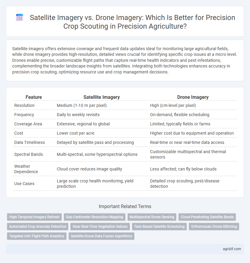
Table of Comparison
| Feature | Satellite Imagery | Drone Imagery |
|---|---|---|
| Resolution | Medium (1-10 m per pixel) | High (cm-level per pixel) |
| Frequency | Daily to weekly revisits | On-demand, flexible scheduling |
| Coverage Area | Extensive, regional to global | Limited, typically fields or farms |
| Cost | Lower cost per acre | Higher cost due to equipment and operation |
| Data Timeliness | Delayed by satellite pass and processing | Real-time or near real-time data access |
| Spectral Bands | Multi-spectral, some hyperspectral options | Customizable multispectral and thermal sensors |
| Weather Dependence | Cloud cover reduces image quality | Less affected; can fly below clouds |
| Use Cases | Large scale crop health monitoring, yield prediction | Detailed crop scouting, pest/disease detection |
Introduction to Precision Crop Scouting
Precision crop scouting leverages advanced technologies like satellite and drone imagery to monitor crop health and optimize yield. Satellite imagery provides wide-area coverage with consistent temporal data, ideal for large-scale agronomic analysis. Drone imagery captures high-resolution, localized data, offering detailed insights for precise intervention and crop management decisions.
The Role of Imagery in Modern Agriculture
Satellite imagery provides comprehensive, large-scale views of agricultural fields, enabling the monitoring of crop health, soil conditions, and moisture levels over extensive areas with frequent revisit times. Drone imagery offers high-resolution, customizable data for detailed crop scouting, allowing farmers to detect stress, pests, and nutrient deficiencies at a sub-field level with rapid deployment. Integrating satellite and drone imagery enhances precision agriculture by combining broad coverage with fine-scale insights, optimizing decision-making for crop management and yield improvement.
Satellite Imagery: Overview and Capabilities
Satellite imagery offers comprehensive coverage and frequent revisit times, enabling large-scale crop monitoring with high temporal resolution. Advanced multispectral and hyperspectral sensors capture detailed data on plant health, soil moisture, and nutrient levels, facilitating accurate disease detection and stress assessment. Its ability to integrate with GIS and machine learning models enhances predictive analytics, supporting efficient decision-making in precision agriculture.
Drone Imagery: Overview and Advantages
Drone imagery offers high-resolution, real-time data crucial for precision crop scouting, enabling farmers to detect early signs of pest infestations, nutrient deficiencies, and water stress with greater accuracy than satellite imagery. The flexibility of drones allows for targeted flights over specific fields at optimal times and lower cloud interference, providing timely and actionable insights. Enhanced spatial resolution and customizable sensors on drones contribute to more precise crop monitoring, supporting efficient resource management and improved yield outcomes.
Spatial Resolution: Satellites vs Drones
Drones provide superior spatial resolution for precision crop scouting, capturing images with detail down to a few centimeters per pixel, enabling accurate detection of crop stress and pest infestations. In contrast, satellite imagery typically offers spatial resolutions ranging from 30 centimeters to several meters per pixel, which may miss early-stage issues or small-scale variability within fields. This fine-scale data from drones supports targeted interventions and improved yield predictions in precision agriculture.
Temporal Resolution: Revisiting Frequency
Satellite imagery provides consistent temporal resolution with frequent revisit cycles, often capturing fields daily or every few days, enabling timely detection of crop health changes. Drone imagery, while offering higher spatial resolution, has limited temporal frequency due to operational constraints, often resulting in less frequent data collection. Optimizing precision crop scouting involves balancing satellite's frequent coverage and drone's detailed insights to ensure accurate and timely crop monitoring.
Costs and Accessibility: Comparing Investment and Operation
Satellite imagery offers broad coverage at lower initial costs but involves subscription fees and limited revisit frequency, impacting timely decision-making in precision crop scouting. Drone imagery requires higher upfront investment in equipment and training but provides high-resolution, customizable data with flexible deployment schedules. Accessibility to satellite data depends on service providers and geographic region, while drones necessitate regulatory compliance and operator availability, influencing overall operational costs and scalability.
Data Processing and Analysis in Precision Agriculture
Satellite imagery offers extensive coverage and frequent revisit times, enabling large-scale crop health monitoring with multispectral and hyperspectral data that supports temporal analysis in precision agriculture. Drone imagery provides higher spatial resolution and flexibility for targeted data collection, facilitating detailed analysis through advanced algorithms for stress detection, disease identification, and yield estimation. Integrating satellite and drone data enhances precision crop scouting by combining broad-area insights with precise, high-resolution information, optimizing data processing workflows and decision-making in precision agriculture.
Best Use Cases: When to Choose Drones or Satellites
Satellite imagery offers broad, frequent coverage ideal for monitoring large agricultural regions and observing crop health trends over time with multispectral data. Drone imagery provides high-resolution, customizable, and timely data perfect for targeted field scouting, detecting early disease symptoms, pest infestations, and precise plant-level analysis. Choosing drones is best for detailed, localized assessments, while satellites excel in large-scale, continuous monitoring to optimize resource allocation and crop management strategies.
Future Trends: Integrating Satellite and Drone Imagery
Integrating satellite and drone imagery in precision crop scouting enhances spatial and temporal resolution, enabling farmers to monitor crop health more accurately and respond swiftly to stress indicators. Advances in AI and machine learning facilitate real-time data fusion from both sources, optimizing yield predictions and resource management. Future trends indicate seamless interoperability between satellite platforms like Sentinel-2 and high-resolution drone sensors, driving smarter, data-driven agricultural practices.
Related Important Terms
High-Temporal Imagery Refresh
Satellite imagery offers high-temporal imagery refresh rates with global coverage, enabling frequent monitoring of crop health changes over large agricultural areas. In contrast, drone imagery provides ultra-high-resolution data but typically with lower revisit frequency, making satellites more efficient for continuous, timely precision crop scouting.
Sub-Centimeter Resolution Mapping
Drone imagery provides sub-centimeter resolution mapping critical for precision crop scouting, enabling detailed analysis of plant health, pest infestations, and nutrient deficiencies at the individual plant level. Satellite imagery, while offering broader field coverage, typically lacks the fine spatial resolution required for detecting subtle variations, making drones more effective for high-precision agricultural decision-making.
Multispectral Drone Sensing
Multispectral drone sensing in precision agriculture offers higher-resolution imagery and targeted spectral data compared to satellite imagery, enabling more accurate detection of crop stress, nutrient deficiencies, and pest infestations. Drones provide flexible, on-demand flight scheduling and lower latency data acquisition, facilitating timely interventions for improved crop management and yield optimization.
Cloud-Penetrating Satellite Bands
Satellite imagery leveraging cloud-penetrating bands such as synthetic aperture radar (SAR) offers consistent, all-weather crop monitoring capabilities that drone imagery cannot match due to optical sensor limitations. These radar frequencies enable precision crop scouting through persistent data collection, improving pest detection, moisture assessment, and crop health analysis despite cloud cover.
Automated Crop Anomaly Detection
Satellite imagery offers extensive coverage and frequent updates, enabling large-scale automated crop anomaly detection through high-resolution multispectral data and advanced machine learning algorithms. Drone imagery provides ultra-high-resolution, customizable flight paths for detailed plant-level anomaly detection, improving precision in monitoring crop health and targeting interventions.
Near-Real-Time Vegetation Indices
Satellite imagery provides broad, multispectral data for near-real-time vegetation indices, enabling large-scale crop health monitoring but with lower spatial resolution and longer revisit times. Drone imagery offers high-resolution, flexible, and timely data acquisition, enhancing precision crop scouting by capturing detailed vegetation indices that reflect immediate field conditions.
Task-Based Satellite Scheduling
Task-based satellite scheduling enhances precision crop scouting by providing timely, high-resolution imagery that adapts to specific agronomic needs and growth stages, outperforming drones in large-scale monitoring. Satellite systems like Planet Labs and Sentinel offer frequent revisits and expansive coverage, enabling efficient detection of crop stress and nutrient deficiencies without the operational constraints of drone battery life and flight regulations.
Orthomosaic Drone Stitching
Orthomosaic drone stitching produces high-resolution, georeferenced maps that enable precise crop health monitoring and field variability analysis, surpassing satellite imagery which often suffers from lower resolution and infrequent capture intervals. This advanced drone imagery technique facilitates real-time decision-making in precision agriculture by generating detailed and accurate spatial data critical for targeted crop scouting and management.
Targeted UAV Flight Path Analytics
Targeted UAV flight path analytics enhance drone imagery's precision in crop scouting by optimizing data collection over specific field zones identified through satellite imagery's broad spectral insights. Integrating satellite data with UAV-guided sensor arrays enables accurate monitoring of crop health, stress detection, and variable rate application within high-resolution, geospatially precise frameworks.
Satellite-Drone Data Fusion Algorithms
Satellite-drone data fusion algorithms integrate high-resolution drone imagery with broad-coverage satellite data to enhance precision crop scouting by combining detailed plant-level insights with large-scale environmental monitoring. These algorithms optimize spatial and temporal resolution, enabling more accurate crop health assessments and targeted interventions in precision agriculture.
Satellite Imagery vs Drone Imagery for Precision Crop Scouting Infographic