Yield mapping provides spatial visualization of crop performance by recording yield data across different field zones, enabling targeted decision-making and resource optimization. Yield monitoring collects real-time data on crop yield during harvesting, facilitating immediate adjustments and post-harvest analysis. Both tools are essential in precision agriculture for enhancing harvest accuracy and maximizing productivity.
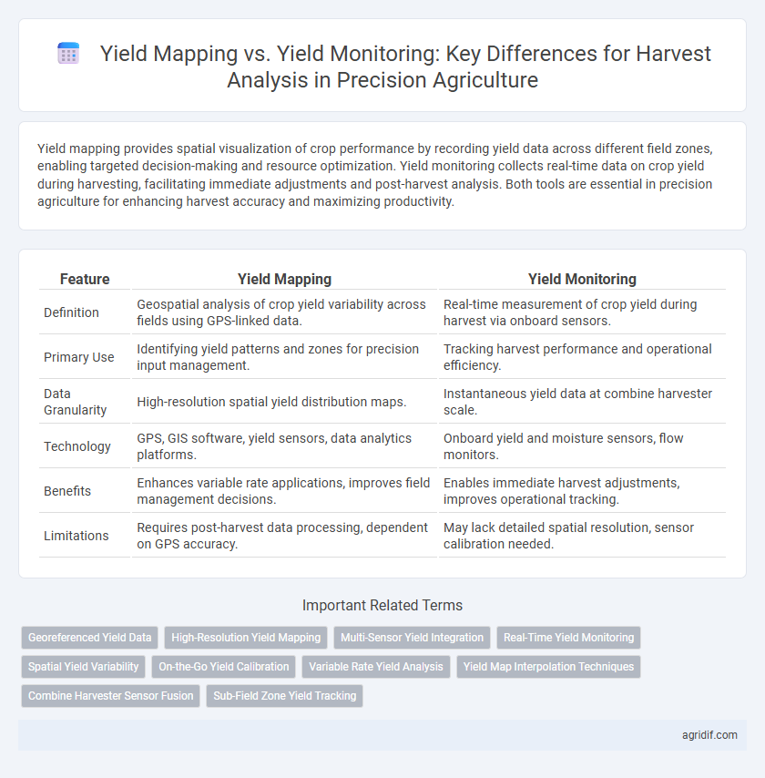
Table of Comparison
| Feature | Yield Mapping | Yield Monitoring |
|---|---|---|
| Definition | Geospatial analysis of crop yield variability across fields using GPS-linked data. | Real-time measurement of crop yield during harvest via onboard sensors. |
| Primary Use | Identifying yield patterns and zones for precision input management. | Tracking harvest performance and operational efficiency. |
| Data Granularity | High-resolution spatial yield distribution maps. | Instantaneous yield data at combine harvester scale. |
| Technology | GPS, GIS software, yield sensors, data analytics platforms. | Onboard yield and moisture sensors, flow monitors. |
| Benefits | Enhances variable rate applications, improves field management decisions. | Enables immediate harvest adjustments, improves operational tracking. |
| Limitations | Requires post-harvest data processing, dependent on GPS accuracy. | May lack detailed spatial resolution, sensor calibration needed. |
Introduction to Precision Agriculture
Yield mapping captures spatial variability in crop production by collecting GPS-linked data during harvest, enabling detailed analysis of field performance. Yield monitoring involves real-time measurement of crop yield, moisture, and other variables using sensors on harvesting equipment to optimize decision-making. Both technologies support precision agriculture by enhancing data-driven management and improving crop productivity.
Defining Yield Mapping and Yield Monitoring
Yield mapping involves creating spatially detailed maps that display variations in crop yield across a field, using GPS and sensor data collected during harvest to analyze productivity patterns. Yield monitoring refers to the real-time measurement and recording of crop yield data by combining yield sensors installed on harvesters with geospatial coordinates. Both yield mapping and yield monitoring are essential tools in precision agriculture, enabling farmers to optimize input use and improve decision-making based on accurate harvest analysis.
Key Technologies Behind Yield Data Collection
Yield mapping integrates GPS technology with combine harvesters to produce spatially referenced crop yield data, enabling precise field-level analysis. Yield monitoring relies on sensors such as mass flow meters, moisture sensors, and ultrasonic sensors to measure grain flow, moisture content, and speed, ensuring accurate yield quantification during harvest. The fusion of GPS, sensor arrays, and data processing units forms the backbone of yield data collection, driving informed decision-making in precision agriculture.
Yield Monitoring: Real-Time Data During Harvest
Yield monitoring captures real-time data on crop yield, moisture content, and machine performance directly during the harvest process, enabling immediate decision-making and adjustments. Equipped with GPS and sensors, yield monitors provide precise spatial information that enhances field variability analysis and resource management. This continuous data stream supports accurate yield mapping after harvest, improving farm efficiency and profitability.
Yield Mapping: Visualizing Spatial Variability
Yield mapping provides a detailed spatial representation of crop performance by capturing real-time data from GPS-enabled combine harvesters, enabling farmers to visualize variability across fields. This spatial variability insight allows for precise decision-making to optimize inputs like fertilizers and irrigation tailored to specific zones. Yield mapping enhances harvest analysis by identifying patterns of high and low productivity, facilitating targeted management practices that improve overall crop yield and profitability.
Data Accuracy and Reliability: Mapping vs Monitoring
Yield mapping generates spatially detailed data by associating GPS coordinates with harvested crop yields, enabling precise field variability analysis, while yield monitoring captures real-time overall crop output during harvest but with less spatial resolution. The accuracy of yield mapping depends heavily on sensor calibration and GPS signal quality, enhancing reliability for targeted agronomic decisions, whereas yield monitoring provides continuous flow data that may be influenced by machine speed variations and sensor errors. Combining both methods improves data fidelity for harvest analysis, optimizing yield estimates and supporting data-driven precision agriculture practices.
Integration with Farm Management Systems
Yield mapping generates spatial data by recording crop yield variations across fields, which integrates seamlessly with farm management systems to facilitate targeted decision-making. Yield monitoring collects real-time harvest data, providing immediate insights into crop performance that can be synchronized with digital platforms for efficient resource allocation. Combining both technologies enhances the accuracy of harvest analysis, enabling comprehensive farm data management and optimizing precision agriculture outcomes.
Benefits and Limitations of Yield Mapping
Yield mapping provides spatially detailed data that enables farmers to identify variability within fields, optimizing inputs and improving crop management decisions for enhanced overall productivity. This technology's precision supports targeted interventions, reducing waste and increasing profitability, but its reliance on accurate GPS and sensor calibration can lead to data inaccuracies if equipment is faulty. Despite limitations such as higher initial costs and the need for technical expertise, yield mapping remains crucial for comprehensive harvest analysis by offering actionable insights beyond aggregate yield figures.
Yield Monitoring: Challenges and Practical Considerations
Yield monitoring in precision agriculture involves real-time collection of crop performance data using sensors integrated with harvesting equipment, presenting challenges such as calibration accuracy, sensor reliability, and data processing complexity. Practical considerations include ensuring proper sensor placement to minimize errors, accounting for variable moisture content affecting yield estimates, and managing large datasets for timely decision-making. Overcoming these challenges requires robust hardware maintenance, effective calibration protocols, and advanced data analytics to translate raw sensor data into actionable insights for optimizing harvest outcomes.
Choosing the Right Approach for Harvest Analysis
Yield mapping provides spatial data visualization of crop performance across fields, enabling targeted decision-making for variable rate applications. Yield monitoring captures real-time harvest data to assess overall productivity and machine efficiency but lacks detailed spatial resolution. Selecting the right approach depends on the need for granular field insights or broad operational metrics in precision agriculture programs.
Related Important Terms
Georeferenced Yield Data
Yield mapping provides detailed georeferenced yield data that enables spatial analysis of crop performance across fields, while yield monitoring offers real-time data collection during harvest without spatial correlation. Georeferenced yield data from yield mapping enhances precision agriculture by identifying variability zones for targeted management and optimizing input use.
High-Resolution Yield Mapping
High-resolution yield mapping provides detailed spatial variability of crop yields across a field, enabling precise identification of high and low productivity zones for targeted management. Unlike yield monitoring, which records overall harvest performance, yield mapping integrates GPS data with real-time yield measurements to generate granular maps that enhance decision-making in precision agriculture.
Multi-Sensor Yield Integration
Yield mapping integrates multi-sensor data such as GPS, combine sensors, and variable rate technology to create detailed spatial yield variability maps, while yield monitoring records real-time crop output during harvest. Multi-sensor yield integration enhances harvest analysis by combining data from moisture sensors, grain flow meters, and geospatial positioning to improve accuracy and inform precision management decisions.
Real-Time Yield Monitoring
Real-time yield monitoring utilizes advanced sensors and GPS technology to collect immediate, high-resolution data on crop output during harvest, enabling precise decision-making and field variability assessment. Unlike yield mapping, which compiles data post-harvest, real-time monitoring enhances responsiveness and operational efficiency by providing instant feedback on yield performance across different field zones.
Spatial Yield Variability
Yield mapping provides detailed geospatial data by integrating GPS technology with yield sensors to visualize spatial yield variability across fields, enabling farmers to identify high and low productivity zones accurately. Yield monitoring collects real-time data on crop output during harvest but offers less spatial resolution, making yield mapping essential for precise site-specific management and improved decision-making in precision agriculture.
On-the-Go Yield Calibration
On-the-go yield calibration enhances both yield mapping and yield monitoring by providing real-time adjustments to sensor data, improving accuracy in harvest analysis. This technique compensates for variables such as moisture content and sensor drift, ensuring precise measurement of crop yield across fields.
Variable Rate Yield Analysis
Yield mapping provides spatially detailed data by associating crop yield with specific field locations, enabling precise variable rate application of inputs based on yield variability. Yield monitoring captures real-time harvest data but lacks the granular field-level resolution necessary for optimized variable rate yield analysis and tailored agronomic decisions.
Yield Map Interpolation Techniques
Yield mapping employs spatial interpolation techniques such as kriging, inverse distance weighting (IDW), and spline methods to create continuous yield surface models from discrete harvest data points, enhancing the precision of yield distribution analysis. Yield monitoring captures real-time variable rate data but relies on interpolation during yield map generation to fill gaps and smooth inconsistencies, making the choice of interpolation algorithms critical for accurate harvest analysis in precision agriculture.
Combine Harvester Sensor Fusion
Yield mapping integrates GPS and combine harvester sensor fusion to create spatially accurate yield data, enabling detailed field variability analysis. Yield monitoring captures real-time crop flow and moisture content via onboard sensors, providing immediate feedback for harvest efficiency optimization.
Sub-Field Zone Yield Tracking
Yield mapping provides detailed spatial data by creating georeferenced maps that illustrate yield variations within sub-field zones, enabling precise identification of high- and low-performing areas. Yield monitoring collects real-time data during harvesting but lacks the granular spatial resolution necessary for targeted management decisions in sub-field zone yield tracking.
Yield Mapping vs Yield Monitoring for Harvest Analysis Infographic